Jump to content

Alto Alegre, Roraima

Coordinates: 02°59′16″N 61°18′16″W / 2.98778°N 61.30444°W / 2.98778; -61.30444
From Wikipedia, the free encyclopedia

This is an old revision of this page, as edited by EmausBot (talk | contribs) at 05:30, 27 August 2010 (robot Adding: nl:Alto Alegre (Roraima)). The present address (URL) is a permanent link to this revision, which may differ significantly from the current revision.

02°59′16″N 61°18′16″W / 2.98778°N 61.30444°W / 2.98778; -61.30444

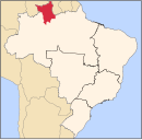
Location of Alto Alegre

Alto Alegre is a city in the Brazilian state of Roraima. The population in 2004 was 19,970, the population density is 0.78/km² and the area is 25,567 km².

Its limits are Amajari to the north, Boa Vista in the east, Mucajaí and Iracema in the south, and Venezuela in the west.