
Rapperswil-Jona
Rapperswil-Jona | |
|---|---|
 | |
 Coat of arms | |
Location of Rapperswil-Jona  | |
| Land | Schweiz |
| Canton | St. Gallen |
| District | See-Gaster |
| Area | |
| • Total | 22.17 km2 (8.56 sq mi) |
| Elevation | 409 m (1,342 ft) |
| Highest elevation (Eggwald, Wagen) | 544 m (1,785 ft) |
| Lowest elevation (Busskirch) | 407 m (1,335 ft) |
| Population (31 December 2018)[2] | |
| • Total | 26,995 |
| • Density | 1,200/km2 (3,200/sq mi) |
| Time zone | UTC+01:00 (Central European Time) |
| • Summer (DST) | UTC+02:00 (Central European Summer Time) |
| Postal code(s) | 8640 |
| SFOS number | 3340 |
| ISO 3166 code | CH-SG |
| Localities | Rapperswil, Jona, Bollingen, Busskirch, Curtiberg, Kempraten-Lenggis, Wagen, Wurmsbach |
| Surrounded by | Altendorf (SZ), Bubikon (ZH), Eschenbach, Freienbach (SZ), Hombrechtikon (ZH), Lachen (SZ), Rüti (ZH), Schmerikon, Tuggen (SZ), Wangen (SZ) |
| Twin towns | Aalborg (Denmark), Bagno di Romagna (Italy) |
| Website | www SFSO statistics |
Rapperswil-Jona is a municipality in the Wahlkreis (constituency) of See-Gaster in the canton of St. Gallen in Switzerland. Besides Rapperswil and Jona, which were separate municipalities until 2006, the municipality includes Bollingen, Busskirch, Curtiberg, Kempraten-Lenggis, Wagen, and Wurmsbach.
Heute


On January 1, 2007, the municipalities of Rapperswil and Jona merged to form a new political entity.[3] Rapperswil-Jona has a population of 25,777 (17,799 from Jona and 7,601 from Rapperswil). This makes it the second largest town in the canton after the capital St. Gallen itself.
Rapperswil-Jona is one of the most significant traffic junctions in the region, and Rapperswil train station is serving as nodal point for the SBB-CFF-FFS respectively Südostbahn and S-Bahn Zürich lines. Zürichsee-Schifffahrtsgesellschaft (commonly abbreviated to ZSG) is operating passenger vessels on the Lake Zürich, connecting surrounding towns between Zürich-Bürkliplatz and Rapperswil. The Seedamm, a dam across Lake Zurich, links Rapperswil with Hurden (SZ) on the other side of the lake. This connection has been part of old pilgrimage routes. From early centuries, a wooden footbridge led across Lake Zurich. At a later stage, the bridge was replaced by a stone dam. In 2001, a new wooden footbridge was opened alongside the dam for the first 840 meters of the crossing. It was built in the same place as the original bridge and links Rapperswil with the nearby bridge chapel (Heilig Hüsli) built in 1551.
The main sights are concentrated in the centre of Rapperswil and can be seen while strolling through the medieval alleys. The main sights of Rapperswil are its roses, the castle, the reconstructed wooden bridge to Hurden with its bridge chapel, and a Capuchin monastery. There are also a number of churches, chapels, and the nearby Wurmsbach Abbey. In the surroundings of the town there are a number of churches. St. John's Church in Rapperswil was built around 1220 and became Rapperswil's parish church in 1253, the Chapel St. Ursula in the village of Kempraten was built around 885. The St. Dionysius Chapel, dedicated to Denis, the first bishop of Paris, was reconstructed in 1493 and attracts pilgrims. The nunnery at Wurmsbach (Wurmsbach Abbey) was established in 1259 and today houses an institute for girls, and St. Martin Busskirch is the former parish church of Rapperswil.
Bollingen is known for the "Tower" built there by Carl Jung. Kempraten is one of the most important archeological sites in the canton of St. Gallen and is located at the eastern parts of the upper Lake Zurich. Jona river is flowing through the municipality in the upper Lake Zürich. In 2006 Rapperswill-Jona hosted the World Orienteering Championships.
History
Settlements in the region of Rapperswil date back at least 5000 years. Atop the Lindenhof hill overlooking a former small village (Endingen), Rapperswil Castle was built around 1220 by the Counts of Rapperswil and is first mentioned in 1229. The town was founded when the nobility of Rapperswil moved from Altendorf across the lake to Rapperswil. The town was soon acquired by the Habsburg family who, in 1358/60, built the wooden bridge across the upper Lake Zürich. Later, the town bought itself free, and ending Old Zurich War made an alliance with the Swiss Confederation. Because of its strategic location along important infrastructure the town grew rich because of flourishing trade. This allowed a certain degree of freedom which was ended with the formation of Swiss cantons by Napoleon. Rapperswil was at first part of the Helvetic canton of Linth. After 1803's Act of Mediation, it joined the canton of St. Gallen. The locational advantage of the place attracted the national Circus Knie who built its headquarters in Rapperswil in 1919. The circus is now also responsible for the Knie's Kinderzoo and the Circus Museum.
Geography
Rapperswil-Jona has an area, as of 2006[update], of 22.2 square kilometers (8.6 sq mi). Of this area, 37.4% is used for agricultural purposes, while 30.6% is forested. Of the rest of the land, 28.6% is settled (buildings or roads) and the remainder (3.4%) is non-productive (rivers or lakes).[4]
The municipality is located in the See-Gaster Wahlkreis and was formed from the merger of Rapperswil (SG) and Jona.
Demograhics
Most of the population (as of 2000[update]) speaks German (86.9%), with Italian being second most common ( 3.1%) and Serbo-Croatian being third ( 2.1%).[4]
In the 2007 federal election the most popular party was the SVP which received 30.3% of the vote. The next three most popular parties were the CVP (19.3%), the SP (17%) and the FDP (13.1%).[4]
In Rapperswil-Jona about 74.6% of the population (between age 25-64) have completed either non-mandatory upper secondary education or additional higher education (either university or a Fachhochschule).[4]
Economy
As of 2007[update], Rapperswil-Jona had an unemployment rate of 1.84%. As of 2005[update], there were 183 people employed in the primary economic sector and about 56 businesses involved in this sector. 3,898 people are employed in the secondary sector and there are 231 businesses in this sector. 8,340 people are employed in the tertiary sector, with 1,077 businesses in this sector.[4]
Heritage sites of national significance
It is home to one or more prehistoric pile-dwelling (or stilt house) settlements that are part of the Prehistoric Pile dwellings around the Alps UNESCO World Heritage Site.[5]
There are five sites that are listed as Swiss heritage sites of national significance. The chapel of St. Dionys, Schloss Rapperswil with the Polish Museum and its archive and the Rathaus (Town Council house) of Rapperswil are the more recent structures. The Roman Vicus at Kempraten and the Seedamm region and historical bridge (which had existed in some form since the prehistoric era through the Middle Ages with the most recent bridge in 2001 and Heilig Hüsli) round out the five.[6]
-

-
 Chapel of St. Dionys
 -
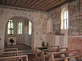 Interior of the chapel
 -
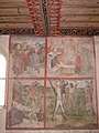 Paintings on the south wall of the chapel
 -
 St. Martin Busskirch on Obersee (upper Lake Zürich)
 -
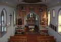 inside the medieval Parish church
 -
 Höllenrachen (Last Judgement) painting inside St. Martin
 -
 Meienberg hill
 -
 Rathaus (Town hall) of Rapperswil
 -
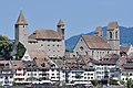 Schloss Rapperswil and Stadtpfarrkirche (St. John's church)
 -
 Polish Museum at the Schloss
 -
 Seedamm bridge across the lake
 -
 reconstruction of the original wooden bridge from c. 1525 BC between Rapperswil and Hurden


_-_Busskirch_St_Martin_IMG_2217_ShiftN.jpg)
_-_Busskirch_St_Martin_IMG_2206_ShiftN.jpg)
_-_Busskirch_St_Martin_IMG_4774_ShiftN.jpg)
_-_Lenggis_Spitzewies_IMG_4965.JPG)


See also
- Settlements comprised by the municipality of Rapperswil-Jona: Bollingen, Busskirch, Jona, Kempraten, Rapperswil
- Points of interest: Circus Knie, Heilig Hüsli, Hochschule für Technik Rapperswil HSR (University of Applied Sciences Rapperswil), Holzbrücke Rapperswil-Hurden, Kapuzinerkloster Rapperswil, Knies Kinderzoo, Paddle steamer Stadt Rapperswil, Polish Museum Rapperswil, Rapperswil Castle, Rathaus Rapperswil, Seedamm, Stadtmuseum Rapperswil, Stadtpfarrkirche Rapperswil, Wurmsbach Abbey
References
- ^ a b "Arealstatistik Standard - Gemeinden nach 4 Hauptbereichen". Federal Statistical Office. Retrieved 13 January 2019.
- ^ "Ständige Wohnbevölkerung nach Staatsangehörigkeitskategorie Geschlecht und Gemeinde; Provisorische Jahresergebnisse; 2018". Federal Statistical Office. 9 April 2019. Retrieved 11 April 2019.
- ^ Amtliches Gemeindeverzeichnis der Schweiz published by the Swiss Federal Statistical Office Template:De icon accessed 23 September 2009
- ^ a b c d e Swiss Federal Statistical Office accessed 07-January-2010
- ^ UNESCO World Heritage Site - Prehistoric Pile dwellings around the Alps
- ^ Swiss inventory of cultural property of national and regional significance 21.11.2008 version, Template:De icon accessed 07-Jan-2010
External links
- Rapperswil-Jona (official site) Template:De icon
- Capuchin monastery Template:De icon
- University of Applied Sciences Rapperswil, HSR (university)
- A brief history of Rapperswil
- Bollingen in German, French and Italian in the online Historical Dictionary of Switzerland.
- Busskirch in German, French and Italian in the online Historical Dictionary of Switzerland.
- Jona in German, French and Italian in the online Historical Dictionary of Switzerland.
- Kempraten in German, French and Italian in the online Historical Dictionary of Switzerland.
Municipalities in See-Gaster district, Switzerland | ||
|---|---|---|
| Settlements |
|   | |||
|---|---|---|---|---|---|
| Islands | |||||
| Rivers | |||||
| Valleys | |||||
| Mountains | |||||
| Landmarks |
| ||||
| Transport | |||||
| Menschen |
| ||||