Mykolaiv
46°58′N 32°0′E / 46.967°N 32.000°E
Mykolaiv (Миколаїв) Nikolayev (Николаев) | |
|---|---|
 Lenin Avenue in Mykolaiv. | |
| Nickname: City of shipbuilders | |
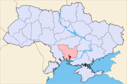
 Map of Ukraine with Mykolaiv highlighted | |
| Country Oblast Raion | Ukraine Mykolaiv Oblast Mykolaiv City Municipality |
| Gegründet | 1789 |
| City rights | 1789 |
| Regierung | |
| • Mayor | Volodymyr Chaika |
| Area | |
| • Total | 259.83 km2 (100.32 sq mi) |
| Population (2008) | |
| • Total | 505,900 |
| • Density | 1,959/km2 (5,070/sq mi) |
| Time zone | UTC+2 (EET) |
| • Summer (DST) | UTC+3 (EEST) |
| Postal code | 54000 |
| Area code | +380 512 |
| Licence plate | BE |
| Website | mykolayiv.osp-ua.info |
Mykolaiv (Ukrainian: Микола́їв), also known as Nikolayev (from Russian Никола́ев), is a city in southern Ukraine, administrative center of the Mykolaiv Oblast. Mykolaiv is the main ship building center of the Black Sea, and, arguably, the whole Eastern Europe.
Name of city
Spelling versions
There are several variations of the city's name. In Ukrainian, the city is named Микола́їв, for which the transliteration is Mykolaiv, or, more rarely, Mykolayiv. The Russian name is Никола́ев, which transliterates as Nikolaev or Nikolayev.
Renaming attempt
In 1920 the Nikolaev council decided to rename the city Vernoleninsk, but the new name was not approved by the Government of the Soviet Union. Nevertheless, in German encyclopedic dictionaries in 1927 and 1932 on the map of European USSR, the city was named Vernoleninsk.
Distinction from another city
To distinct Mykolaiv from the much smaller western city of Mykolaiv in Lviv Oblast, the latter is sometimes called "Mykolaiv on Dniester" after the major river it situated on, while the former is located on the Southern Buh, another major river, and may be called "Mykolayiv on Buh" as well.
Geographical position
The city is located 65 kilometers (40 mi) from the Black Sea along the estuary of the Southern Buh river (where it meets the Inhul River)..
Administrative status
Mykolaiv is the administrative center of the Mykolaiv Oblast (province), as well as that of both the Mykolaivskyi and Zhovtnevyi raions (districts) within the oblast. However, Mykolaiv is also a city of oblast subordinance, and is thus subject directly to the oblast authorities rather to the raion administration housed in the city itself.
Administrative Districts
Mykolaiv is divided into four districts:
- The Central District is located in the northwest of the city. It includes the historic center of Mykolaiv, Rocket tract, Temvod, Salt, Northern, Ternovka (in Ternovca also acts village council), Matveevka, Varvarovka.
- The Zavodskiy District is located in the west of the city. In this area, many industrial enterprises are concentrated. It also includes neighborhoods Lescaut and Alluviation, as well as towns of Velykaya Koreniha and Malaya Koreniha.
- The Leninskiy District is located in the east of Mykolaiv. Among other things, it includes the new Horticulture, YUTZ, New Watering, Old Watering. The district has a zoo, bus and railway stations.
- The Korabelniy District is located in the south of the city. It includes a broad beam, Zhovtnevoe (Ukrainian Жовтневе - "The October"), Balabanovka, Kulbakino.
Economy
Today Mykolaiv is a major shipbuilding center of Ukraine (as, earlier, of the whole Soviet Union) and an important riverport. The city has three major shipyards one of which is capable of building large navy ships. Other important industries are mechanical engineering, power engineering, metallurgy and last 10 years - food industry.
History
The town was founded in 1789 by the Russian Governor General of Novorossiya, Prince Grigori Potemkin, initially as a shipyard called simply a New Shipyard on the Ingul river. Kniaz Potemkin signed an order to construct a shipyard on August 27, 1789, which is considered to be the city's birth date. The shipyard was to undertake the repair of naval ships in the Russo-Turkish War (1787–1792). Later Potemkin ordered the shipyard to be named Nikolaev to commemorate the date when Ochakov fell to the Russian troops under his command on December 6, 1788, close to the day of Saint Nicholas (Nikolay) December 19, in the Russian Orthodox Church calendar.
The history of the city has always been closely connected to ship building. Captain Georgy Brusilov of the ill-fated Arctic ship St Anna was born in Mykolaiv in 1884.
The Lubavicher Rebbe Rabbi Menachem Mendel Schneerson was born in Mykolaiv in 1902. Mykolaiv was occupied by Romania between 1941-1944.
Bildung
There are several universities in Mykolaiv. The main universities are: Admiral Makarov National University of Shipbuilding, Petro Mohyla Black Sea State University, Mykolaiv Pedagogical Institute and Mykolaiv State Agrarian University .
Transport
Mykolaiv Airport, one of the largest and technically well-equipped airports in the South of Ukraine, serves the city. The airport is mainly served by cargo and only limited passenger service is available through this airport. UTAir offers flights from Mykolaiv to Moscow (VKO airport). Almost all passenger service in the South of Ukraine is provided by Odessa International Airport: to reach Mykolaiv tourists had to reach Odessa first and than take bus, taxi or train from Odessa to Mykolaiv.[1]
Sports
Mykolaiv is represented within Ukrainian Bandy and Rink-bandy Federation.[2]
Notable residents
 The famous journalist, playwright, and short story writer Isaac Babel (1894–1940) spent most of his youth in Mykolaiv.
 Menachem Mendel Schneerson, the last rabbi of Chabad-Lubavitch movement, was born in Mykolaiv.
 Nikita Rukavytsya: Ukrainian-born, Australian footballer currently playing for Hertha BSC. Was born in Mykolaiv.
See also
- Black Sea Shipyard
- 61 Kommunara Shipbuilding Plant
- Okean Shipyard (Oktyabrskoye)
References
- Notes
- ^ Ukraine travel guide
- ^ http://translate.google.co.uk/translate?hl=en&sl=ru&u=http://www.niknews.mk.ua/2008/02/04/v-nikolaeve-budut-igrat-v-xokkej-s-mjachom/&ei=hmHBTtjuOYrGswag9aCdAw&sa=X&oi=translate&ct=result&resnum=1&sqi=2&ved=0CCAQ7gEwAA&prev=/search%3Fq%3Dhttp://www.niknews.mk.ua/2008/02/04/v-nikolaeve-budut-igrat-v-xokkej-s-mjachom/%26hl%3Den%26biw%3D1024%26bih%3D677%26prmd%3Dimvns


