Bakoy River
| Bakoy River | |
|---|---|
 | |
| Physical characteristics | |
| Mouth | Sénégal River at Bafoulabé |
• elevation | 83 m |
| Length | 640 km |
| Basin features | |
| River system | Sénégal River |
|
Sénégal River at Oualia, Mali |
|---|
 |
|
Average monthly flow (m3/s) at the Oualia gauging station over the period 1951-1978[1] |
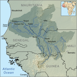
The Bakoy or Bakoye River is a river in West Africa. It runs through Guinea and Mali and joins with the Bafing River to form the Sénégal River at Bafoulabé, in the Kayes Region of western Mali.
It is also called the White River while the Bafing is called the Black River.[2][3] The source of the Bakoy is at an elevation of 760 m in the granite Monts Ménien to the northwest of Siguiri in Guinea. The river flows north and forms part of the international boundary between Guinea and Mali. It then meanders across the Mandingue Plateau. Its principal affluent is the Baloué which rises to the west of Bamako.[4] The Bakoy drains a basin of 85,600 km2. The average flow at the Oualia gauging station, 54 km upstream of Bafoulabé, is 156 m3/s.[1] The discharge of the Bakoy is about a third of that of the Bafing.[5]
References
- ^ a b Hydrographic data for Oualia, Mali 1903-1974, Unesco International Hydrological Programme, retrieved 2-Jun-2012
{{citation}}: Check date values in:|accessdate=(help). - ^ David C. Conrad, Djanka Tassey Condé (2004). Sunjata: A West African Epic of the Mande Peoples. Hackett Publishing. ISBN 0-87220-697-1.
- ^ William R. Jobin (1999). Dams and Disease: Ecological Design and Health Impacts of Large Dams, Canals, and Irrigation Systems. Taylor & Francis. ISBN 0-419-22360-6.
- ^ SENEGAL-HYCOS: Renforcement des capacités nationales et régionales d’observation, transmission et traitement de données pour contribuer au développement durable du bassin du Fleuve Sénégal (Document de projet préliminaire) (PDF) (in French), Système Mondial d’Observation du Cycle Hydrologique (WHYCOS), 2007, p. 4.
- ^ Étude des impacts environnementaux du projet d’aménagement de Félou (PDF) (in French), Organisation pour la mise en valeur du fleuve Sénégal (O.M.V.S.), 2006, pp. 59–61.
External links
