
Neutral Bay
| Neutral Bay Sydney, New South Wales | |||||||||||||||
|---|---|---|---|---|---|---|---|---|---|---|---|---|---|---|---|
Bent_St_Neutral_Bay.jpg) View from Bent Street | |||||||||||||||
| Population | 9,384 (2011)[1] | ||||||||||||||
| • Density | 5,870/km2 (15,200/sq mi) | ||||||||||||||
| Postcode(s) | 2089 | ||||||||||||||
| Area | 1.6 km2 (0.6 sq mi) | ||||||||||||||
| Standort | 5 km (3 mi) north of Sydney CBD | ||||||||||||||
| LGA(s) | North Sydney Council | ||||||||||||||
| State electorate(s) | North Shore | ||||||||||||||
| Federal division(s) | North Sydney, Warringah | ||||||||||||||
| |||||||||||||||
Neutral Bay is a harbourside suburb on the Lower North Shore of Sydney, New South Wales, Australia. Neutral Bay is around 5 kilometres north of the Sydney central business district, in the local government area of North Sydney Council.[2]
Neutral Bay takes its name from the bay on Sydney Harbour. Kurraba Point, formerly a locality in Neutral Bay, was declared a separate suburb in 2010, sharing the postcode 2089. Surrounding suburbs include North Sydney, Cammeray, Milsons Point, Cremorne and Cremorne Point.
History
The name "Neutral Bay" originates from the time of the early colonial period of Australia, where different bays of Sydney harbour were zoned for different incoming vessels. This bay was where all foreign vessels would dock, hence the name neutral.[3]
The Aboriginal name for the area was 'Wirra-birra'. In 1789, soon after the arrival of the First Fleet in Sydney, Governor Arthur Phillip declared this bay a neutral harbour where foreign ships could anchor and take on water and supplies.[4] Neutral Bay was far enough away from Sydney Cove to discourage convicts from escaping on these vessels and to keep possible enemy ships at a distance from the main settlement.[5]
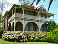
By the beginning of the 20th century, Neutral Bay and Cremorne were developing as "alternative society suburbs", populated by the kind of people who were attracted to the Arts and Crafts architectural style that was in vogue at the time.[6] This style was an attempt to get away from mass production and give homes the "human touch". Notable examples soon appeared in the area. Brent Knowle, in Shellcove Road, was designed by Bertrand James Waterhouse and built in 1914.[7] It influenced home design in the area for at least the next fifteen years[8] and has a state heritage listing.[9]
A different style was used for The Cobbles, also in Shellcove Road. Designed by Peddle and Thorp and built in 1918, it made great use of natural stones and pebbles to achieve the desired look. It is an Australian interpretation of the California Bungalow style and has a state heritage listing.[10]The Gables, in Spruson Street, was another Waterhouse design and was built in 1920. It was influenced by the "shingle style" which was brought to Sydney by Horbury Hunt, and featured prominent gables and extensive use of shingles. More Waterhouse designs appeared in Shellcove Road in the vicinity of The Cobbles and Brent Knowle.[8] An outstanding example is Ailsa, which was designed by Waterhouse for Capt. Robert Craig and built in 1908. It has a state heritage listing.[11] Along with Keynsham, St Anne's and Gundimaine House, these homes form a significant heritage group and have a state heritage listing.[12][13]
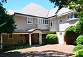
Neutral Bay was also the home of the painter May Gibbs, who lived for many years at Nutcote, a home in Wallaringa Avenue (now classified as Kurraba Point). The house was designed by B.J.Waterhouse and built 1924-25. It was later restored and is now open to the public as a museum. It has a state heritage listing.[14] Before living at Nutcote, Gibbs lived for a time in Derry, a two-storey Federation home in Phillips Street.
Commercial area

The main shopping district of Neutral Bay, known as Neutral Bay Junction, is along Military Road, which is the main road that runs through Neutral Bay, Cremorne and Mosman. It features many quality shops, restaurants and cafes. The Big Bear shopping centre is a shopping mall that features a supermarket and grocery shops.
The Oaks Hotel is a well-known and popular venue located on the corner of Military Road and Ben Boyd Road. It has been a popular meeting place in Sydney since 1885. The Oaks Hotel features a number of restaurants, bars, function rooms and an impressive beer garden with the main focal point an old oak tree that provides plenty of shade to patrons in summer.
Transport
There are two operating ferry wharves at Neutral Bay, serviced by both public Inner harbour ferry services and private ferries. The Neutral Bay wharf sits at the end of Hayes Street and the Kurraba wharf on Kurraba Point can be accessed by Kurraba Road.
The Warringah Freeway runs along the western border of Neutral Bay, providing links south to the Sydney CBD and north to Chatswood. Military Road has been a prominent local electoral issue, due to issues relating to the heavy traffic congestion on the road.
Schools
Churches
- St Joseph's Catholic Church
- St Augustine's Anglican Church
- St John's Uniting Church
- Spiritualist Church
Parks and recreation
The Norths Pirates Junior Rugby Union Club is the local village Rugby Club, the former Club being known as Cammbridge Bay. This Club taking its name from Northbridge, Cammeray and Neutral Bay. The Pirates play home games at Tunks Park Cammeray and train at Primrose Park in Cremorne and Anderson Park, Neutral Bay.
The Neutral Bay Club is a tennis and bowls club, bistro and sports bar situated next to Ilbery Reserve in the centre of Neutral Bay.[15] In continuous operation since 1882, it is one of the oldest licensed clubs in New South Wales.[16] The club features four floodlit tennis courts, a floodlit bowling green surrounded by a heated deck, two function rooms and a members lounge.[17] It runs teams of various levels in the Sydney tennis and bowls leagues, with its lady bowlers having regularly won the Sydney Pennant.[18]
Gallery
-
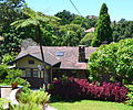 The Cobbles
 -
 Military Road shopping centre
 -
 Derry, home of May Gibbs before she lived at Nutcote
 -
 The Oaks Hotel
 -
 Brent Knowle
 -
 Ailsa
Ailsa
The_Cobbles.jpg)

_Derry(former_home_of_May_Gibbs)1.jpg)
The_Oaks_Neutral_Bay.jpg)
Brent_Knowle3.jpg)
_Ailsa.jpg)
References
- ^ Australian Bureau of Statistics (31 October 2012). "Neutral Bay (State Suburb)". 2011 Census QuickStats. Retrieved 5 November 2012.
- ^ Gregory's Sydney Street Directory, Gregory's Publishing Company, 2007
- ^ The Book of Sydney Suburbs, Compiled by Frances Pollen, Angus & Robertson Publishers, 1990, Published in Australia ISBN 0-207-14495-8, page 185
- ^ Sydney Harbour Federation Trust Sites - Macquarie
- ^ Naming North Sydney Image Library
- ^ Sydney Architecture, Graham Jahn (Watermark Press) 1997
- ^ A Pictorial Guide to Identifying Australian Architecture, Apperly (Angus and Robertson) 1994, p.142
- ^ a b Sydney Architecture
- ^ State Heritage Website
- ^ State Heritage Website
- ^ State Heritage Website
- ^ State Heritage Website
- ^ State Heritage Website
- ^ State Heritage Website
- ^ http://www.northsydney.nsw.gov.au/www/html/2992-ilbery-reserve.asp
- ^ http://www.au.timeout.com/sydney/sports/venues/5462/neutral-bay-club
- ^ http://neutralbayclub.com/the-club
- ^ http://neutralbayclub.com/bowls/competition-bowls
External links
- Neutral Bay in Dictionary of Sydney
- Dictionary of Sydney: Kurraba Point