
Apuseni Mountains


The Apuseni Mountains (Romanian: Munții Apuseni, Hungarian: Erdélyi-középhegység) is a mountain range in Transylvania, Romania, which belongs to the Western Romanian Carpathians, also called Occidentali in Romanian. Their name translates from Romanian as Mountains "of the sunset" i.e. "western". The highest peak is Cucurbăta Mare (Hungarian: Nagy-Bihar) - 1849 metres, also called Bihor Peak. The Apuseni Mountains have about 400 caves.
Geography
The Apuseni Mountains do not present an uninterrupted chain of mountains, but possess many low and easy passes towards the Crișana and the Great Hungarian Plain. Going from south to north the principal groups are: the Munții Metaliferi ("Ore Mountains") with the basaltic masses of the Detunata (1,148 metres (3,766 ft)) near Abrud; the Bihor Mountains, with romantic scenery and numerous caverns, with the highest peak the Curcubăta Mare (1,843 metres (6,047 ft)); to the east of this group are the Muntele Mare (highest peak 1,820 metres (5,970 ft)), to the southwest of Cluj-Napoca; the northernmost chain is the Seș and Meseș Mountains.
Boundaries
- to the north: the Barcău River
- to the south: the Mureş River
- to the east: the Transylvanian Plateau
- to the west: the Crişana plains
Subdivisions


Criş Mountains (Munţii Crişului, Hungarian: Körös-menti hegyvidék) :
- Criş Hills (Dealurile Crişene,Hungarian: Körös-menti dombság), incl. Beiuş Depression (Depresiunea Beiuş, Hungarian: Belényesi-medence), Vad Depression (Depresiunea Vad, Hungarian: Révi-medence)[1]
- Pădurea Craiului Mountains (literally:Forest of the King, Hungarian: Királyerdő-hegység)
- Codru-Moma Mountains (Munţii Codru-Moma, Hungarian: Béli-hegység)[2]
Seş-Meseş Mountains (Munţii Seş-Meseşului):
- Meseş Mountains (Munţii Meseşului, Hungarian: Meszes-hegység)
- Seş Mountains (Muntele Seş, Hungarian: Réz-hegység, also Plopiş)
- Şimleu Depression (Depresiunea Şimleu Silvanei, Hungarian: Szilágysomlyói-medence), often considered part of the Transylvanian Basin-Podişul Someşan
- Şimleu Mountains (Munţii Şimleu, Hungarian: Szilágysági-dombvidék), often considered part of the Transylvanian Basin-Podişul Someşan[3]
Bihor Massif (Masivul Bihor, Hungarian: Bihari-havasok):
- Bihor Mountains (Munţii Bihorului, Hungarian: Bihar-hegység)
- Vlădeasa Mountains (Munţii Vlădeasa, Hungarian: Vlegyásza-hegység)
- Muntele Mare Mountains (literally: Big Mountain), (Munţii Muntele Mare, Hungarian: Öreghavas)
- Gilău Mountains (Munţii Gilăului, Hungarian: Gyalui-havasok)
Mureş Mountains (Munţii Mureşului, Hungarian: Marosmenti-hegyvidék):
- Zarand Mountains (Munţii Zarandului, Hungarian: Zarándi-hegység)
- Metalliferous Mountains (Munţii Metaliferi, Hungarian: Erdélyi-érchegység)
- Trascău Mountains (Munţii Trascăului, Hungarian: Torockói-hegység)
Gallery
-
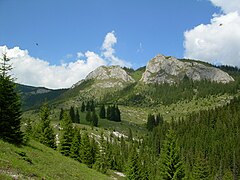 Vlădeasa
 -
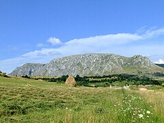 Piatra Secuiului
 -
-

-
 Cheile Turzii
 -
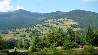 Arieşeni
 -
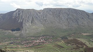
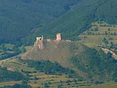 Cetatea Trascăului


.JPG)


See also
References
- ^ "Románia Földrajza". Ordogborda.hu. Retrieved 2013-02-22.
- ^ http://www.hungarian-history.hu/lib/hmcb/hmcb15.htm
- ^ "HAJDÚ-MOHAROS JÓZSEF (19572001) HEVESI ATTILA HORVÁTH ZSOLT A KárpátPannon térség természeti tájbeosztása". Lazarus.elte.hu. Retrieved 2013-02-22.
{{cite web}}: C1 control character in|title=at position 27 (help)
External links
- Template:Ro icon Photos from Apuseni Mountains
- Template:Ro icon Tourist attractions in Apuseni Mountains
- Website with information about the Carpathians Mountains
- Apuseni Mountains - photographs + information in Czech
- Pictures of the Apuseni Mountains
- Awarded "EDEN - European Destinations of Excellence" non traditional tourist destination 2009

Divisions, Groups, and Ranges of the Carpathian Mountains | ||||||
|---|---|---|---|---|---|---|
| Western Carpathians |
|  | ||||
| Eastern Carpathians |
| |||||
| Southern Carpathians | ||||||
| Western Romanian Carpathians | ||||||
| Serbian Carpathians | ||||||
| Adjacent regions | ||||||
| Grouping by country | ||||||
46°30′N 23°00′E / 46.500°N 23.000°E
| International | |
|---|---|
| National | |
| Geographic | |