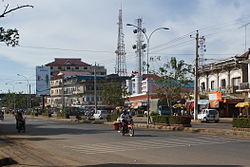
Kampong Thom city
Appearance
Kampong Thom
ក្រុងស្ទឹងសែន | |
|---|---|
 Steung Saen | |
| Country | |
| Province | Kampong Thom |
| District | Stueng Saen District |
| Elevation | 10 m (30 ft) |
| Population (2008) | |
| • Total | 31,871 |
| Time zone | UTC+7 (Cambodia) |
Kampong Thom (Khmer: ក្រុងកំពង់ធំ krong kampongthom, "Grand Port") is the capital city of Kampong Thom Province, Cambodia lying on the bank of the Steung Saen River.[1][2] It is a mid-way stopover on the National Highway No 6 halfway between Phnom Penh and Siem Reap.[3]
The Kampong Thom High School is North of the river bridge, and the Kampong Thom Market is on the south side of the bridge, followed by the main street and dual carriageway. Further south along the road is Steung Saen City (Khmer: ក្រុងស្ទឹងសែន krong steungsaen) also a district in Kampong Thom Province and a side road to the Floating Pagoda (វត្ត ក្ដីអណ្ដែត).
Kampong Thom is marked by a roundabout with a statue of an elephant crushing a tiger.
References
- ^ Communicating Climate-Change and Natural Hazard Risk and Cultivating Jeanette L. Drake, Yekaterina Y. Kontar, John C. Eichelberger 3319201611 2015 "Kampong Thom is one of the major regional centers in central Cambodia and is located on the lower Stung Sen River basin."
- ^ Kampong Thom, a picturesque town on the banks of the Stung Saen River
- ^ Matt Jacobson Adventure Cambodia: An Explorer's Travel Guide 9749575539 2004 p131 "Highway 6 continues on to the left, going to Kampong Thom and Siem Reap."
Wikivoyage has a travel guide for Kampong Thom.
