Sóndor
Appearance
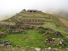
 View of Suntur | |
| Location | Pacucha District, Andahuaylas Province, Apurímac Region, Peru |
|---|---|

Suntur (Quechua,[1][2] hispanicized spelling Sondor) is an archaeological site in Peru built by the Chanka people. The main part consists of a temple like structure used for religious and astronomical purposes. It is located in the Apurímac Region, Andahuaylas Province, Pacucha District.[3]
References
- ^ sondor.gob.pe Historia "Sóndor 156 años de Creación Política"
- ^ Teofilo Laime Ajacopa (2007). Diccionario Bilingüe: Iskay simipi yuyayk’anch: Quechua – Castellano / Castellano – Quechua (PDF). La Paz, Bolivia: futatraw.ourproject.org.
- ^ turismoi.pe/arqueologia "Complejo Arqueológico Sondor o centro ceremonial Sondor" (Spanish)
External links
Wikimedia Commons has media related to Suntur.
13°36′23″S 73°16′08″W / 13.6063°S 73.2689°W
