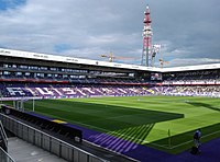
Franz Horr Stadium
Generali Arena | |
 The Generali Arena in July 2018 | |
 | |
| Location | Vienna, Austria |
|---|---|
| Capacity | 17,656 |
| Opened | 30 August 1925 |
| Tenants | |
| FK Austria Wien | |
The Generali Arena (Viola Park for international matches) is a football stadium in the south of Vienna, Austria. It has been the home ground of FK Austria Wien since 1973. The stadium was built in 1925 as the new home of Czech immigrants' club SK Slovan Vienna and had a capacity of 10,850.[1] Named after another Czech football club which owned the ground, the stadium was called České srdce ("Czech heart") ground. Largely destroyed during World War II, each of the four stands has been reconstructed several times since. The stadium was renamed Franz-Horr-Stadion in honour of the Wiener Fußball-Verband's (Vienna Football Association) president Franz Horr who died in 1974.
The latest renovation was the complete reconstruction of the East Stand in 2008. It is now a transformable standing/seating two-tier stand. After these modifications, the stadium's maximum capacity is now 17,656.
In January 2011, the stadium was renamed Generali Arena, as part of a sponsorship deal between FK Austria Wien and the insurance group Generali. Since UEFA does not recognize sponsored stadium names, the venue is referred to as Viola Park in European competitions, including in their upcoming stage of 2020 UEFA Women's Champions League Final.[2]
References
- ^ https://www.uefa.com/MultimediaFiles/Download/StatDoc/competitions/-Publications/01/67/58/96/1675896_DOWNLOAD.pdf
- ^ "Who will succeed Lyon: road to Vienna". Union of European Football Associations. 18 May 2019.
