
Turtle Mountain Indian Reservation
This article needs additional citations for verification. (July 2016) |

Turtle Mountain Indian Reservation (Ojibwe language: Mikinaakwajiwing) is a reservation located in northern North Dakota, United States.[1] It is the land base for the Turtle Mountain Band of Chippewa Indians.[1] The population of the Turtle Mountain Indian Reservation consists of Plains Ojibwe and Métis and was first established in the year 1882.[1]
Reservation

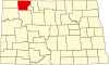
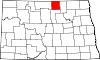
The main reservation is located in Rolette County, North Dakota.[2] The size of the reservation is six miles by twelve miles, and is one of the most dense reservations, population wise, in the United States.[2] It has a land area of 67.583 square miles (175.04 km2) and a 2016 estimated population of 6,369 persons.[citation needed] It also has extensive off-reservation trust lands, which make the reservation's lands the most widely dispersed of all reservations in the nation.[citation needed]
These lands are spread across 22 counties in three states: North Dakota, Montana and South Dakota. Including these lands, the reservation's land area is a total of 233.036 square miles (603.56 km2). Its total resident population at the 2000 census was 8,331.[citation needed]
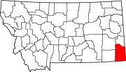
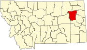
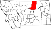
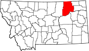
The largest portion of off-reservation trust land is located in Rolette County, with significant parcels in Phillips, Blaine, Sheridan and Roosevelt counties in Montana; and in Williams County, North Dakota. Sixteen other counties have lesser amounts of trust land.[citation needed]
The Turtle Mountains range along what is now known as the Manitoba and North Dakota border.[1] They consist of a vast spreading of hills, wetlands and plateaus situated along the border, and are where the Turtle Mountain Indian Reservation is located.[1] Despite being named mountains, the Turtle Mountains are not considered to be mountains, but a collection of plateaus and hills.[1] In the United States, the plateau is not as extensively covered by a forest as in the Canadian part of the plateau. The forest that covers the plateau is clear evidence that the boreal forest extended much further westward.[citation needed] It is only slightly higher in elevation than the neighboring prairie, about 500 feet or more, though there are several prominent points, including Boundary Butte on the plateau's western edge with over 1000 feet of prominence. Many lakes dot the plateau, which is evidence that the area was covered by a large lake in ancient times.[citation needed]
Land status
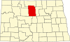
The main part of the Turtle Mountain Reservation is located in Rolette County, North Dakota. It covers 72 square miles (46,000 acres; 19,000 ha). Another 26,175 acres (10,593 ha) is located in Rolette County, North Dakota, around the Turtle Mountain Reservation.[citation needed] Total acres in Rolette County are 72,255 acres (29,241 ha). Another 6,698 acres (2,711 ha) is managed by the Trenton Agency.[citation needed] Much of the Trenton land is in Montana. The remaining land, totaling 67,852 acres (27,459 ha), is located primarily in Montana, with small parcels in North Dakota and South Dakota.[citation needed] It is one of a few Native American Reservations that protected its lands against white settlement. The total area of the Turtle Mountain Reservation is 146,805 acres (229.383 sq mi; 59,410 ha).[citation needed]
History
In the early 19th century (around 1810–1820), Chippewa and Metis warriors battled with white fur trade companies over sensitive issues. Included was trespassing on Indian land and disagreements over the lucrative pemmican. Pemmican was vital to the Chippewa and to the white fur trade companies. The Pemmican War was fought over the lucrative pemmican trade. The Battle of Seven Oaks was the major battle of the war.[citation needed]
Historians claim the Chippewa still controlled nearly 10 million acres in 1892. That is nearly 15,000 sq mi. In the late 1880s, the United States sent representatives to chief Little Shell III and his councilors, to negotiate a deal for the acreage still owned by them. Chief Little Shell III was living in Montana and was not pleased about the issue. The negotiations continued on for several years and finally ended in 1891, when the United States selected 32 Chippewa leaders to negotiate and sign the McCumber Agreement. That occurred in 1892.[citation needed]
In 1882, the Turtle Mountain Reservation was established; it was originally much larger than today. In 1884, the United States reduced the size of the Turtle Mountain Reservation to two townships or 46,080 acres. The Chippewa ceded much of their land before the reservation was established. [citation needed]
Chief Little Shell III ceded the land in exchange for a large Reservation that bordered the Fort Peck Reservation in Montana. During the negotiations over the 10 million acres in the early 1890s, the Chippewa leader and the US could not come to agreement. The United States forced chief Little Shell III and several hundred of his supporters off the reservation rolls, making them landless.[citation needed]
Throughout the mid 1860s, the bison population experienced a decline. Bison are a crucial resource for Métis populations, being important in the ways of life and the economy, as it as often sold and traded. This decline in bison numbers negatively impacted the Métis of Turtle Mountain.[3] Many Plains Ojibwe moved to Turtle Mountain in the eighteenth century. This caused tensions between Métis and Plains Ojibwe, as they has to share these lands. Differences in histories and relations sparked tensions between the two groups.[1] Although having tensions in some areas, Plains Ojibwe and Métis shared similar political goals for the future such as the goal to create a reservation that would be federally recognized and gaining recognition, on a federal level, of a political identity.[1] In February 1876, a document written by the Chippewa Indians of Turtle Mountain was signed by Little Shell III. This addressed the three points in political discussions with the federal government. These included the establishment of a reservation, the request to be politically recognized and the ability to sell land. As the resources available on the land were diminishing as a result of settler encroachment, the population of Turtle Mountain wanted the option to sell land.[3] The year 1876 saw the implementation of a bill that would create a reservation for the lands claimed by Métis and Ojibwe. By 1882, there was increasing violence between the people of Turtle Mountain and white settlers, as settlers continued to encroach on Turtle Mountain.[3] The United States federal government began interfering with the lives of the population of Turtle Mountain and forced them to pay taxes to the federal government.[3]
In March 1884, the president of the United States at the time, Chester Arthur, reduced the size of the reservation to six by twelve miles. It still has these same dimensions today.[3] This reduction was a 90 percent decrease in the size of the land, causing aggravations across the people of Turtle Mountain. Through sentiments of disappointment due to the large reduction of land size, Metis and Plains Ojibwe were brought together, however still had some divisions in goals.[3]
In 1892, discussion by the United States federal government led to the political assimilation of Plains Ojibwe and Métis, they were now seen as one political group. They remained two distinct groups towards each other despite the federal governments decision.[3] As a result of the Northwest resistance, many Métis of Saskatchewan went to Turtle Mountain to stay with relatives, increasing tensions and numbers on the reservation. Those living on the reservation did not have adequate space and the overcrowding caused a faster decline in the resources available on the land, causing deaths due to starvation and disease.[3] Agricultural practices were no longer possible and the numbers of bison were declining rapidly. This reduction of available resources caused further tension between Métis and plains Ojibwe.[3] Harsh climates on the reservation made the living conditions very difficult. Cold winters and dry summers made agriculture practices very difficult on the reservation.[3]
The population of Turtle Mountain was lent with the same constitution that was developed in 1932. This constitution was not effective and did not comply with the needs of the people of Turtle Mountain.[3] In 1946, claims could be filed to the Indian Claims Commission. Despite the slow process, the people of Turtle Mountain won a claim surrounding the impacts they faced as a result of the McCumber Agreement.[3] Despite this, poor living conditions on the reservation persisted and the average household income on the reservation was far below that of the rest of North Dakota.[3] A vote in 2002 revealed the rejection of a new constitution while another vote in 2003 revealed an even greater rejection of a new constitution.[3]
McCumber Agreement
In 1904, an agreement was put into effect between the Turtle Mountain Band of Chippewa Indians and the United States federal government. This became the McCumber agreement and was signed by the Turtle Mountain Band of Chippewa Indians in 1905.[3] The McCumber Agreement stated that the people of Turtle Mountain would sell the land of the reservation of a price of $1 million.[3] As this was not considered to be a great deal of money, it was also named the "Ten Cent Treaty".[3] There was much resistance from the people of Turtle Mountain towards the implementation of this agreement. Little Shell III was the leader of the Plains Ojibwe however, his authority was diminishing, as he was not able to address all of the issues that were occurring in the community as a result of the agreement.[3] Little Shell III had a large presence in the resistance of the agreement, however his death in 1900 reduced the resistance.[3] In 1920, the population of Turtle Mountain formed a committee which sought to propose a lawsuit against the United States federal government due to the failed results of the McCumber Agreement.[2] The federal government took 10 million acres of land at 10 cents per acre and created a reservation South of the Turtle Mountains, with diminishing resources.[3] The McCumber Agreement did not attain the political goals of the people of Turtle Mountain. No improvements were made upon the crowded living conditions and many issues such as starvation, poverty and disease persisted.[3]
The Constitution
In 1932, a tribal constitution was implemented on Turtle Mountain, 27 years after the signing of the McCumber Agreement.[2] The people of Turtle Mountain were informed that the implementation of this constitution would make their claims clear to the federal government.[1] The constitution ended up giving much power to the United States federal government. As a result of this, the constitution was not accepted by the Turtle Mountain Band of Chippewa Indians, as it did not respect the community.[1] In 1934, the Turtle Mountain band of Chippewa Indians were against the establishment of a new constitution by the Indian Reorganization Act.[1] The Indian Reorganization Act was still passed in 1934, two years after the establishment of the constitution, claim that its goals were to reestablish tribal governments.[1][2]
Selkirk Concession
Chief Sitting Bull was hinting at something now hidden from the present, when he told General Terry that "...For 64 years you have kept us and treated us bad." Sitting Bull was probably 46 at the time. Around 1811, the Selkirk Concession was supposedly issued by the Hudson's Bay Company to Thomas Douglas, 5th Earl of Selkirk. The land was not white but Anishinaabe. It covered a large area of land in Canada and the northern United States including parts of eastern Saskatchewan, southern Manitoba, northwestern Ontario, northern Minnesota, eastern North Dakota and northeastern South Dakota. The Turtle Mountains were within the land area of the Selkirk Concession. It is also known as the Red River Colony and the District of Assiniboia. However, Sitting Bull may have not been recalling an unknown event 64 years before 1877, but a treaty the Anishinaabe Nation signed with the whites which set aside a huge Reservation around 1870. It may have dealt with a Reservation the whites have totally erased from history. In fact, it may be related to the infamous "10 cent an acre treaty".[citation needed]
Trenton Indian Service Area
An agency of the Turtle Mountain Reservation, the Trenton Indian Service Area was established back in the 1970s, to manage the Chippewa land allotments in northeastern Montana and northwestern North Dakota. Only one community is affiliated with the Trenton Indian Service Area and that is Trenton, North Dakota. Around 500 people live in Trenton, which is an unincorporated community. Trenton is only a few miles from Montana. The Trenton Indian Service Area does not manage all the Turtle Mountain Chippewa land allotments. Fort Peck Agency manages some, as does the Fort Belknap Agency, Northern Cheyenne Agency and the Cheyenne River Agency of South Dakota.[citation needed]
Grahams Island
It is a part of the Turtle Mountain Reservation. Grahams Island may be some 60 miles from the Turtle Mountain Reservation, but much of the island was allotted to some Turtle Mountain Chippewas. The island is located on the north side of Devils Lake near the Spirit Lake Indian Reservation. Much of the island is covered by a forest. The island was the location of Chief Little Shell I village in the very early 1800s. Other Turtle Mountain land allotments are located in Liberty County, Montana, which is west of the Rocky Boy Reservation and only 47 miles from the Blackfeet Reservation.
Communities
Several Chippewa settlements are located on and around the small Reservation. East Dunseith is located on the plateau. It is surrounded by a forest and many lakes. Shell Valley is located in the extreme southwestern part of the reservation. In fact, Shell Valley may be off reservation, located on off Reservation trust land, as is East Dunseith. Shell Valley is not on the plateau. Belcourt is situated on the southeastern edge of the plateau. The forest is to the east, north and west of the CDP. Many lakes are also located around Belcourt.[citation needed]
Dunseith is not on the reservation but is also predominantly Indian, even more so than St. John. Just east of Belcourt is an area, formerly known as Turtleville, which had over 100 housing units in 1997. Using Google Earth, the same area appears to have had the housing units torn down. However, about a mile east of the same area, another set of housing units has recently been built. The area has over 70 housing units. The name of the settlement is Kent's Addition, named after Senator Kent Conrad, who helped gain funding for the housing project.[citation needed]
Directly south of the Kent's Addition is another area where a large number of housing units are located called Green Acres Housing. The area has around 33 housing units.[citation needed]
East Dunseith Housing which must not be confused with East Dunseith, may have up to 80 housing units. East Dunseith Housing is just under a mile east of Dunseith. The population of East Dunseith may be between 240 and 320.[citation needed]
- Belcourt, North Dakota
- East Dunseith, North Dakota
- East Dunseith Housing, North Dakota
- Green Acres, North Dakota
- Kent's Addition
- Shell Valley, North Dakota (most, population 395)
Economy
Turtle Mountain Reservation economic conditions are largely centered on government. The government of the Turtle Mountain Reservation employ 854 people. The government jobs include federal, state, local agencies and the schools on the Reservation. The government of the Turtle Mountain Reservation also owns the Turtle Mountain Manufacturing Company which has an employment force of 186. Another tribally owned company is Uniband. Uniband employs 350 people in the Belcourt region. Other large employers on the Turtle Mountain Reservation include Indian Health Service which employs 215 people, and the Turtle Mountain Community College which employs 60 people. The casino owned by the Turtle Mountain Reservation government, has a work force of 300 people.[citation needed]

In the private sector, it is estimated that there are at least 135 Indian owned businesses on the Turtle Mountain Reservation and around the Reservation, but problems abound. According to the 2000 census, 8,331 live on the Turtle Mountain Reservation but the unemployment rate was near 50%. The estimated 2000 employment force was 5,222. Of that total, 2,748 were employed and 2,474 were unemployed. The per capita annual income is near $12,000. The poverty rate is at 38%.[citation needed]
According to the Bureau of Indian Affairs, in 2010, the unemployment rate of the Turtle Mountain Reservation was 69.25 percent. In this same year, approximately 40 percent of families living on the reservation were living below the poverty line.[2] As a result of the labour market, there were issues in relocating from the reservation into cities. This resulted in 45 percent of those who left the reservation to return.[4]
Climate
Climate conditions on the Turtle Mountain Reservation are extreme. Winters are long and cold. Average winter lows at Belcourt during December, January, and February are -4°F, -11°F and -6°F. Average high temperatures for the same months are 16°F, 11°F and 17°F. Summers are short and warm. Average high temperatures for June, July and August at Belcourt are 72°F, 78°F and 76°F. Average summer low temperatures are a bit on the chilly side at Belcourt. The average low temperatures for June, July and August are 47°F, 52°F, 48°F. Average precipitation at Belcourt is near 18 inches. The region might be included as being in Tornado Alley.[citation needed]
Notable residents
- Thomas Little Shell, resisted the McCumber agreement and was leader of Plains Ojibwe.[3] He left his Montana home and moved to the Turtle Mountain Reservation. He died and was buried there in 1901.[citation needed]
- Leonard Peltier, a leader of the American Indian Movement, grew up here.[citation needed]
- Louise Erdrich, writer, grew up on Turtle Mountain Reservation, and is an enrolled member of the Turtle Mountain Band of Chippewa Indians.[citation needed]
- William Jennings Gardner, an American football player, coach, and a law enforcement agent.[citation needed]
- Keith Richotte Jr., a judge on the Turtle Mountain Court of Appeals.[1]
References
- Turtle Mountain Reservation and Off-Reservation Trust Land, Montana/North Dakota/South Dakota United States Census Bureau
External links
- Turtle Mountain Band of Chippewa Indians official site
- copies of reservation-pertinent documents
- Sitting Bull's Turtle Mountain Grave
- Assessment of Groundwater Quality Data for the Turtle Mountain Indian Reservation, Rolette County, North Dakota, 1970-2012 United States Geological Survey
48°51′00″N 99°47′01″W / 48.85000°N 99.78361°W
1 No reservation in state, trust lands or legal status only |
1 No reservation in the state, trust lands or legal status only |


- ^ a b c d e f g h i j k l m Reinhardt, Akim (2019). "Keith richotte jr. claiming turtle Mountain's constitution: The history, legacy, and future of a tribal Nation's founding documents". The American Historical Review.
{{cite web}}: CS1 maint: url-status (link) - ^ a b c d e f Martin-Parisien, Terri J. (2016). "Exploring the Impact of Self-Determination on the Political Practices of the Turtle Mountain Band of Chippewa Indians: A Critical Content Analysis". The University of North Dakota.
{{cite web}}: CS1 maint: url-status (link) - ^ a b c d e f g h i j k l m n o p q r s t u v Richotte Jr., Keith (2017). Claiming Turtle Mountain's Constitution: The History, Legacy, and Future of a Tribal Nation's Founding Documents. The University of North Carolina Press.
- ^ Philip, Kenneth (1985). "Stride toward Freedom: The Relocation of Indians to Cities, 1952-1960". Western Historical Quarterly.
{{cite web}}: CS1 maint: url-status (link)
- American Indian reservations in Montana
- American Indian reservations in North Dakota
- American Indian reservations in South Dakota
- Anishinaabe reservations and tribal-areas in the United States
- Ojibwe
- Native American tribes in North Dakota
- Native American tribes in South Dakota
- Native American tribes in Montana
- Geography of Blaine County, Montana
- Geography of Burke County, North Dakota
- Geography of Carter County, Montana
- Geography of Cavalier County, North Dakota
- Geography of Chouteau County, Montana
- Geography of Daniels County, Montana
- Geography of Divide County, North Dakota
- Geography of Fergus County, Montana
- Geography of Hill County, Montana
- Geography of Liberty County, Montana
- Geography of McCone County, Montana
- Geography of McHenry County, North Dakota
- Geography of McLean County, North Dakota
- Geography of Mountrail County, North Dakota
- Geography of Perkins County, South Dakota
- Geography of Phillips County, Montana
- Geography of Richland County, Montana
- Geography of Rolette County, North Dakota
- Geography of Roosevelt County, Montana
- Geography of Sheridan County, Montana
- Geography of Valley County, Montana
- Geography of Williams County, North Dakota
- 1882 establishments in Montana Territory