Urban Municipality of Slovenj Gradec
Appearance
City Municipality of Slovenj Gradec
Mestna občina Slovenj Gradec | |
|---|---|
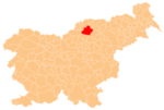
 Location of the Municipality of Slovenj Gradec in Slovenia | |
| Coordinates: 46°31′N 15°05′E / 46.517°N 15.083°E | |
| Land | |
| Regierung | |
| • Mayor | Tilen Klugler |
| Area | |
| • Total | 173.7 km2 (67.1 sq mi) |
| Population (2002)[1] | |
| • Total | 12,779 |
| • Density | 74/km2 (190/sq mi) |
| Time zone | UTC+01 (CET) |
| • Summer (DST) | UTC+02 (CEST) |
| Postal code | 2380 |
| Website | www |
| Source: Statistical Office of the Republic of Slovenia, census of 2002. | |
The City Municipality of Slovenj Gradec (pronounced [slɔˈʋeːŋ ˈɡɾaːdəts]; Slovene: Mestna občina Slovenj Gradec) is a municipality in northern Slowenien. The seat of the municipality is the town of Slovenj Gradec. It is part of the historic Styria region, and since 2005 it has belonged to the NUTS-3 Carinthia Statistical Region.[2]
Settlements
In addition to the town of Slovenj Gradec, other settlements in the municipality are Brda, Gmajna, Golavabuka, Gradišče, Graška Gora, Legen, Mislinjska Dobrava, Pameče, Podgorje, Raduše, Sele, Šmartno pri Slovenj Gradcu, Šmiklavž, Spodnji Razbor, Stari Trg, Tomaška Vas, Troblje, Turiška Vas, Vodriž, Vrhe, and Zgornji Razbor.
References
External links
 Media related to City Municipality of Slovenj Gradec at Wikimedia Commons
- Slovenj Gradec municipal website (in Slovene)
- City Municipality of Slovenj Gradec on Geopedia

