
Kota Kinabalu District
Kota Kinabalu District
Daerah Kota Kinabalu | |
|---|---|
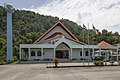
.jpg) Kota Kinabalu City Hall. | |
 Flag  Seal | |
 | |
| Coordinates: 5°58′13″N 116°04′14″E / 5.97028°N 116.07056°E | |
| Country | |
| State | |
| Division | West Coast |
| Capital | Kota Kinabalu |
| Government | |
| • Mayor of City Council | Datuk Haji Nordin Siman |
| • MP |
|
| • MLA | |
| Area | |
| • Total | 350 km2 (140 sq mi) |
| Population (2010) | |
| • Total | 462,963 |
| Website | dbkk |
The Kota Kinabalu District (Malay: Daerah Kota Kinabalu) is an administrative district in the Malaysian state of Sabah, part of the West Coast Division which includes the districts of Kota Belud, Kota Kinabalu, Papar, Penampang, Putatan, Ranau and Tuaran. The capital of the district is in Kota Kinabalu City.
Demographics
According to the 2010 census, the population of the district was 462,963. The main ethnic groups were the Chinese (20%), Kadazan-Dusun (15%), Bajaus (16%), Malays (8%) and Muruts (6%).[1] As in most other parts of Sabah, there was also a significant number of illegal immigrants from the southern Philippines - mainly from the Sulu Archipelago and Mindanao - many of whom are not included in the population statistics.
Gallery
-

-
 Kota Kinabalu Basel Church.
 -
 Mary Immaculate Catholic Church.
 -
 Kota Kinabalu Latter Day Saint Church.
 -
 Kota Kinabalu Seventh Day Adventist Church.
 -

-

-
 Gurdwara Sahib Kota Kinabalu.
 -
 Kota Kinabalu city centre.


See also
References
- ^ "Population by ethnic group, Local Authority area and state, Malaysia" (PDF). Department of Statistics, Malaysia. 2010. Archived from the original (PDF) on 27 February 2012. Retrieved 5 November 2017.
Further reading
- Treacher, W. H (1891). "British Borneo: sketches of Brunai, Sarawak, Labuan, and North Borneo". University of California Libraries. Singapore, Govt. print. dept. p. 190.
{{cite web}}: Invalid|ref=harv(help) - Rutter, Owen (1922). "British North Borneo - An Account of its History, Resources and Native Tribes". Cornell University Libraries. Constable & Company Ltd, London. p. 157.
{{cite web}}: Invalid|ref=harv(help) - Tregonning, K. G. (1965). A History Of Modern Sabah (North Borneo 1881–1963). University of Malaya Press.
{{cite book}}: Invalid|ref=harv(help)
External links
![]() Media related to Kota Kinabalu District at Wikimedia Commons
Media related to Kota Kinabalu District at Wikimedia Commons
- (in Malay) Kota Kinabalu City Hall
Capital: Kota Kinabalu | |||||||||||
| Topics | |||||||||||
| Society | |||||||||||
| Administrative divisions |
| ||||||||||
This Sabah location article is a stub. You can help Wikipedia by expanding it. |