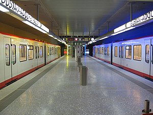
Gustav-Adolf-Straße station
Appearance
| Nuremberg U-Bahn station | |||||||||||
 | |||||||||||
| General information | |||||||||||
| Standort | Gustav-Adolf-Straße 90439 Nürnberg, Germany | ||||||||||
| Coordinates | 49°26′21″N 11°02′14″E / 49.4390413°N 11.0372095°E | ||||||||||
| Operated by | Verkehrs-Aktiengesellschaft Nürnberg | ||||||||||
| Line(s) | |||||||||||
| Connections |
| ||||||||||
| Bauwesen | |||||||||||
| Structure type | Underground | ||||||||||
| Other information | |||||||||||
| Fare zone | VGN: 100[1] | ||||||||||
| History | |||||||||||
| Opened | 14 June 2008 | ||||||||||
| Services | |||||||||||
| |||||||||||
Gustav-Adolf-Straße station is a Nuremberg U-Bahn station, located on the U3. The station is named for the Swedish king Gustavus Adolphus.
References
- ^ "Tarifzonenplan: Nürnberg, Fürth" (PDF). Verkehrsverbund Großraum Nürnberg. 1 January 2019. Retrieved 20 October 2019.

