
Les Useres
Les Useres | |
|---|---|
| Les Useres/Useras | |
 Coat of arms | |
 Les Useres Location in Spain | |
| Coordinates: 40°9′25″N 0°9′54″W / 40.15694°N 0.16500°W | |
| Land | |
| Autonomous community | |
| Province | Castellón |
| Comarca | Alcalatén |
| Judicial district | Castellón de la Plana |
| Regierung | |
| • Alcaldesa | Delia Valero Ferri (2007) (PSOE) |
| Area | |
| • Total | 80.7 km2 (31.2 sq mi) |
| Elevation | 401 m (1,316 ft) |
| Population (2018)[1] | |
| • Total | 966 |
| • Density | 12/km2 (31/sq mi) |
| Demonym | Useranos |
| Time zone | UTC+1 (CET) |
| • Summer (DST) | UTC+2 (CEST) |
| Postal code | 12118 |
| Official language(s) | Valencian |
| Website | Official website |
Les Useres (Valencian: [lez uˈzeɾes]) (known in Spanish as Useras (Spanish: [uˈseɾas]) is a municipality in the comarca of Alcalatén in the Valencian Community, Spain. In August 2007, 120 residents had to be evacuated as a result of a forest fire.[2]
Gallery
-
 Christ of l'Agonia (Les Useres)
 -
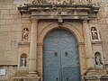 Portico of the Església parroquial in Les Useres
 -
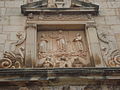 Altarpiece of the Transfiguració
 -
 Street in Les Useres
 -
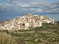 Panoramic view of Les Useres
 -
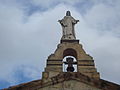
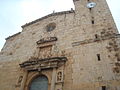 Facade of the Església parroquial in Les Useres
 -
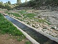 View of la Font de La Presola


.JPG)

.JPG)
References
- ^ Municipal Register of Spain 2018. National Statistics Institute.
- ^ AFP via ABC News Australia, "Death and destruction in Med's ring of fire" 31 August 2007
Municipalities of Alcalatén | ||
|---|---|---|
| International | |
|---|---|
| National | |
This article about a location in the Valencian Community, Spain, is a stub. You can help Wikipedia by expanding it. |