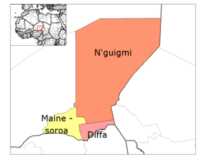
Mainé-Soroa Department
Appearance
This article relies largely or entirely on a single source. (May 2023) |
Mainé-Soroa | |
|---|---|
 Mainé-Soroa Department location in the region | |
| Land | |
| Region | Diffa Region |
| Area | |
| • Total | 2,909 sq mi (7,534 km2) |
| Population (2012 census) | |
| • Total | 131,664 |
| • Density | 45/sq mi (17/km2) |
| Time zone | UTC+1 (GMT 1) |
Mainé-Soroa is a department of the Diffa Region in Niger. Its capital lies at the city of Mainé-Soroa.
The department's population is largely made up of ethnic Kanouris and Fula, both cultures with longstanding pastoral semi-nomadic traditions. As of 2012, the department had a total population of 131,664 people.[1][2]
Communes
References
- ^ "Annuaires_Statistiques" (PDF). Institut National de la Statistique. Retrieved 2 May 2013.
- ^ "Maïné-Soroa (Department, Niger) - Population Statistics, Charts, Map and Location". www.citypopulation.de. Retrieved 2024-02-21.
13°12′41″N 12°01′26″E / 13.21139°N 12.02389°E
