In brief: We are now less than 24 hours before Beryl will make landfall in Texas, likely near Matagorda, which is located about 90 miles south-southwest of Houston. Along this track the greater Houston area, particularly the western half of the metro area, will see significant effects in the form of strong, battering winds in addition to heavy rainfall. This post will assess all of these threats, and their timing.
Tropical Storm Beryl status
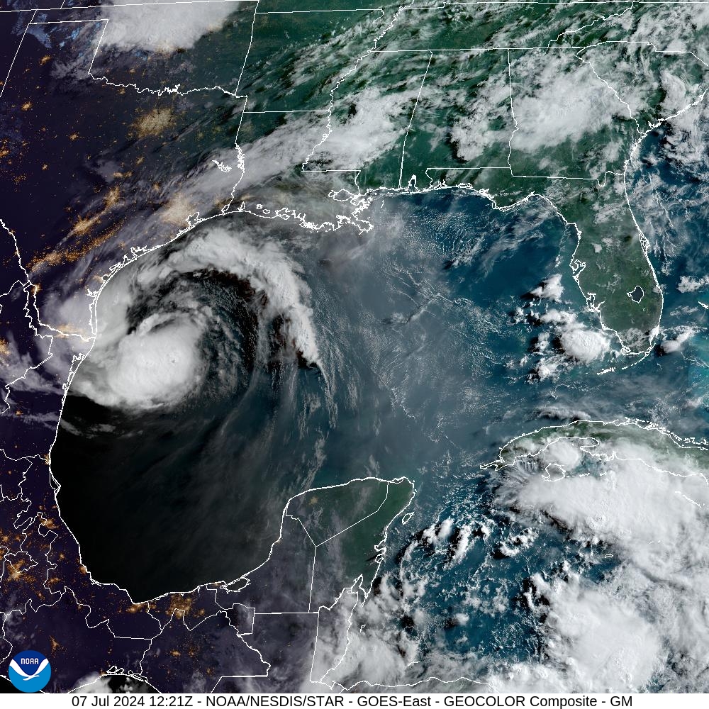
As of 7 am CT, Tropical Storm Beryl still has sustained winds of 60 mph. Its central pressure is largely unchanged overnight, dropping only slightly from 993 to 992 millibars. This indicates that Beryl has yet to begin the process of significantly intensifying. The storm is almost due south of Galveston Island, and is moving to the northwest at 12 mph.
It is good that Beryl has not changed much overnight, but forecasters still expect the storm to find favorable conditions for intensification during the next 18 to 24 hours before it makes a final landfall along the Texas coast.
Track of Beryl and its intensity
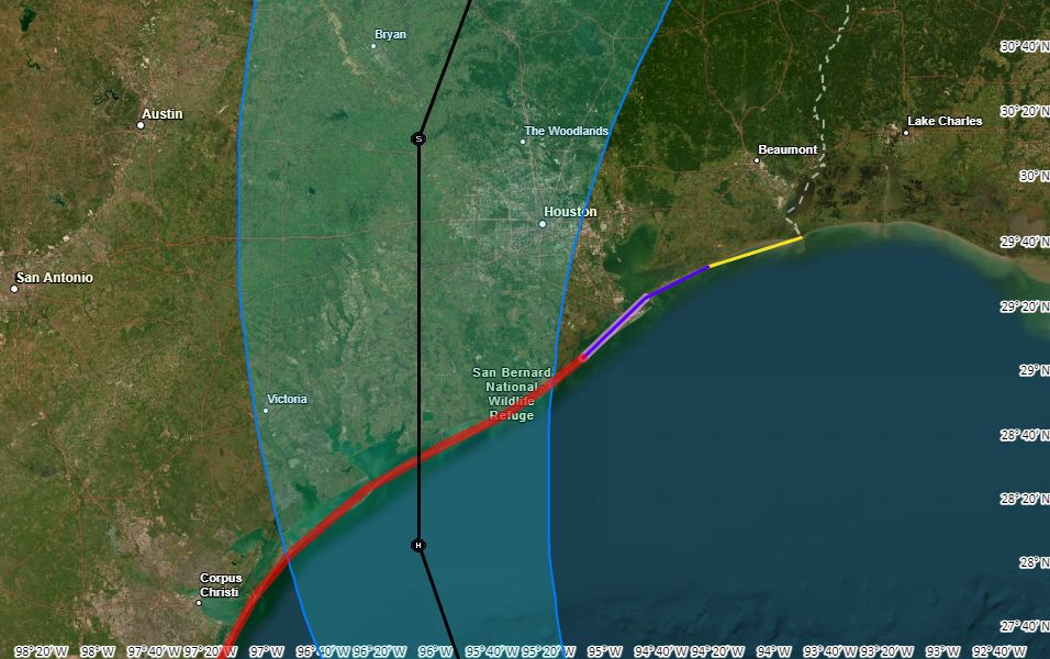
The trends in the overnight model runs for Beryl have not been great for the Houston metro area. The most likely track remains a landfall near Matagorda, but this could still change today with a wobble in one direction or another as a better defined center of circulation forms. Along this track the Houston region will be subjected to some of the strongest winds and heaviest rains from Beryl.
Forecasters still expect Beryl to intensify today, given the lowering wind shear levels and ample moisture in the atmosphere. The National Hurricane Center predicts the storm will be a Category 1 hurricane with 85 mph winds at landfall early on Monday morning. This could be an overestimate if Beryl continues to struggle with getting organized today. However, the most likely scenario is strengthening today, with the potential for rapid intensification tonight. Expect a Category 1 or Category 2 hurricane at landfall.
Conditions on Sunday prior to landfall
Beginning later this morning, Houston may see fairly widespread showers and thunderstorms as the outer rainbands of Beryl move inland. These storms may be briefly intense, but should be navigable for the most part. Winds will be increasing today and this evening from the southeast, but still within manageable levels, with gusts in the 20s. For coastal areas, conditions will start to deteriorate after sunset, with inland areas, including the city of Houston, seeing markedly stronger winds by late evening and after midnight.
Beryl’s winds
Beryl will produce strong winds near its center and to its right. Although there are still likely to be some subtle changes in the storm’s track and location of its is strongest winds, it is now clear that strong winds will cause significant impacts for the greater Houston area, including the potential for widespread power outages. The extent of these outages will depend on the strengthening of Beryl today and tonight as it nears the Texas coast. Other concerns include downed trees and damaged roofs. It is strongly advisable to secure loose objects today, prior to Beryl’s landfall.
The greatest impacts are likely to be in locations such as Sargent, Freeport, and Lake Jackson. However, tropical storm-force winds are also likely along Galveston Island and large parts of the Houston metro area, particularly to the south and west of the city.
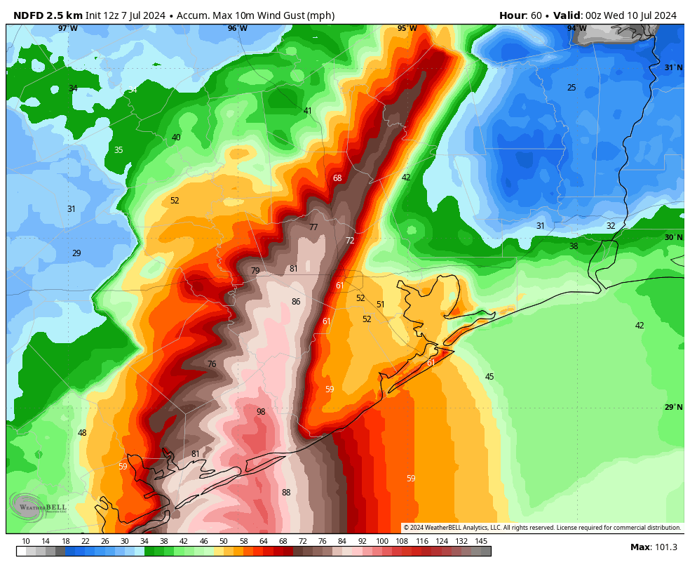
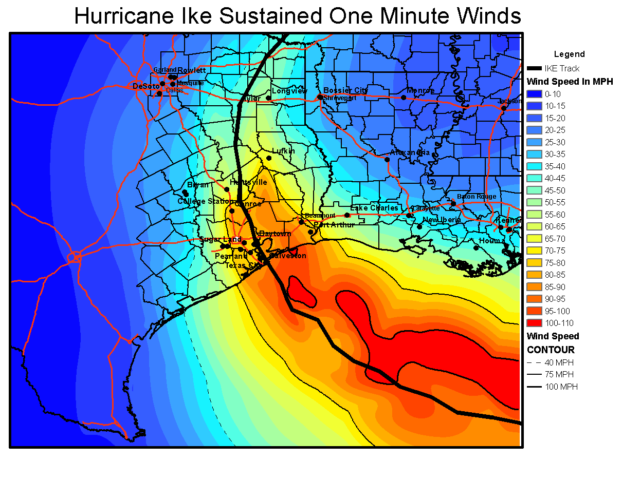
Matagorda, Wharton, Fort Bend, and Brazoria counties are likely to see the strongest winds, with sustained winds of 45 to 75 mph, and higher gusts. Most of the rest of the Houston metro area is at risk for winds of 35 to 55 mph, with higher gusts. If you’re wondering how these compare to Hurricane Ike, here is a map of sustained peak winds during that notable 2008 hurricane.
These winds will peak between late Sunday night and sunrise for coastal areas, and a little bit later for inland areas. Winds will be receding area-wide by Monday afternoon.
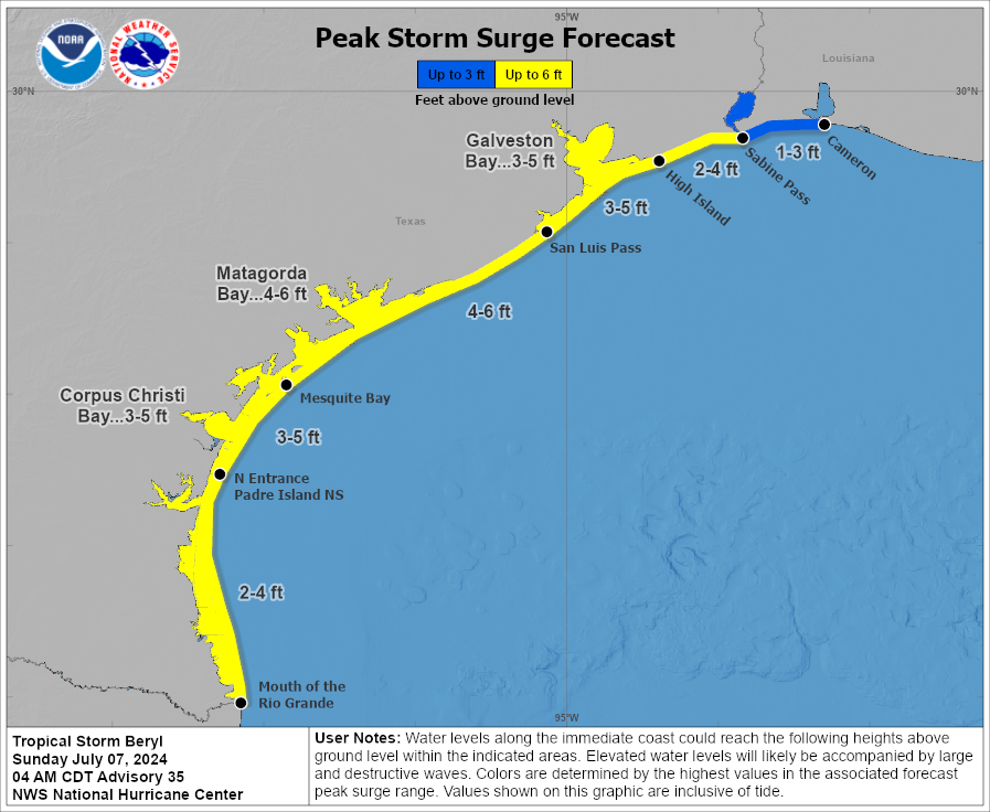
Beryl’s storm surge
Storm surge occurs when a hurricane’s winds align with the onshore flow, pushing large amounts of water onto land. Its most significant impacts occur over immediate coastal areas, and the storm surge level typically peaks along with high tide. In Beryl’s case, water levels are already higher than normal with the storm’s winds. Surge levels should peak between 6 am and 9 am CT on Monday before rapidly receding later in the day, likely reaching near-normal levels by Monday night.
Due to Beryl’s track, expected storm surge levels have ticked a little bit higher. Galveston Island and Galveston Bay should now see a surge 3 to 5 feet above normal levels.
Inland rainfall potential
Beryl’s track also places the core of its heavier rains over the Houston metro area. Coastal areas are likely at the highest risk for heavy rainfall, with 5 to 10 inches likely from Matagorda Bay to Galveston Island, and higher isolated totals. Further inland, much of the Houston area can probably expect 4 to 8 inches, with higher isolated totals. Since this rainfall will come down rapidly, we can expect streets to rapidly flood.
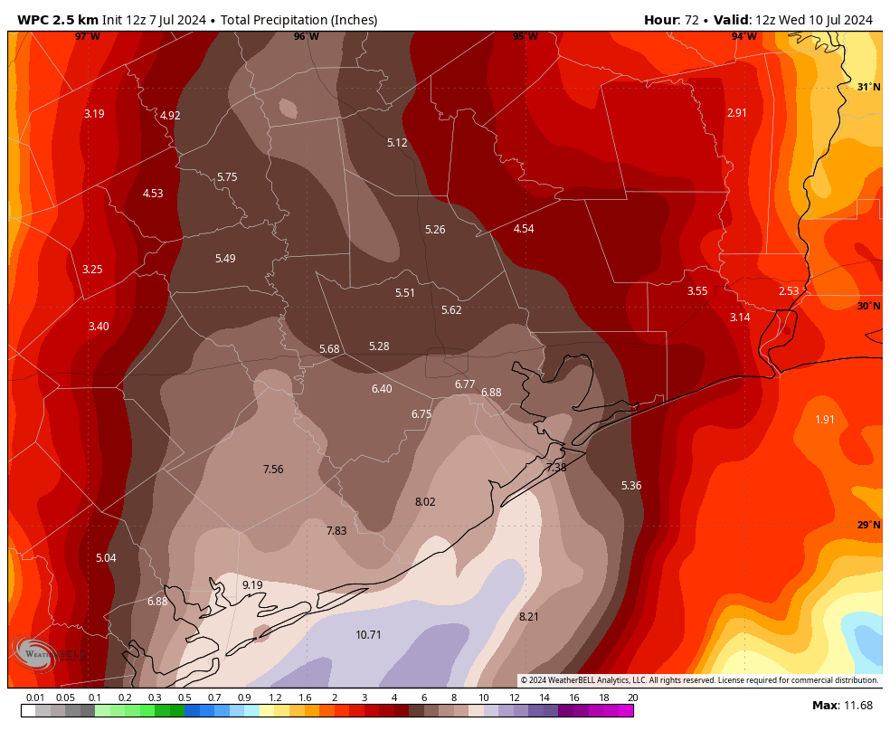
Although stronger thunderstorms will be possible this evening, the most intense rainfall should occur between midnight tonight and noon on Monday. After this time the storm will be pulling away to the north of the city. I cannot rule out an additional trailing band of rainfall later on Monday or Monday night. However, the fairly rapid northward movement of Beryl after landfall is our friend. We have issued a Stage 2 flood alert for the entire Houston metro area.
How should you be thinking about this
Beryl will be an impactful storm for the Houston region. This is far from a worst-case scenario hurricane for our area, but it will be significantly disruptive tonight and on Monday. Beginning this evening, you should shelter in your home. The worst of the winds and rains will come tonight and into Monday morning, with improving conditions thereafter. Due to the likelihood of street flooding on Monday morning, you should carefully consider any plans before noon.
The current track forecast indicates the possibility of widespread power outages, and the duration of these outages will depend on how many people lose power as it will mean more work for restoration crews.
In terms of programming, I will be conducting a video Q&A on our Facebook page at 1 pm CT today. You can submit questions in the comments below for that chat, if you like. Dwight will also have a post today about maximizing the potential of weather data on your phone to understand local conditions during the height of the storm. Our next major update on Beryl’s track and its implications for Houston will come around 4:30 pm CT today.

Thoughts on flights into Hobby on Southwest this evening and early Monday am?
Per the SWA app, flights to HOU Hobby may be disrupted (delayed, diverted, and/or canceled.)
Can you try & get on a flight earlier today or just stay where you are til Tuesday? That’s what I would do if I were you.
As the guys mentioned in previous posts, they can’t give you information on what the airlines/airports are going to do. Common sense says that both airports are going to be cancelling flights tomorrow. Calling your airline is the best bet.
Both airports are delivering information on expectations tomorrow. Google Houston Airports, Hurricane Beryl. All the airlines are now offering free changes/cancellations. Call Southwest. I change my AM flight from Hobby. It will probably be cancelled.
So, for Houston, to what extent is this a slightly stronger version of Nicholas two years ago?
Ooops…three years ago.
I don’t think anyone really remembers Nicholas – so this should be your clue that it was not a big deal.
Did some damage in Clear Lake. Part of the eyeball sheared off and went over us. Tornado in the subdivision.
Tornadoes are a whole different ball game. They scare me more than a hurricane. They’re unpredictable and move around so crazily. They can do more damage in half a minute than a whole day of hurricane winds and rain
Nicholas wasn’t so bad. The center of the eye went 1,200 feet east of my house. We didn’t even lose power and the rickety fence didn’t blow over.
We actually got a lot of damage to our house, but hey I got to redo my living room and kitchen.
I recall that most of Nicholas’ wind and rain stayed offshore as it passed by Houston. That doesn’t look to be the case with Beryl.
Eyeballing the maps above, for the Clear Lake area, the predicted winds are about 59 miles per hour, up to 8 inches of rain and the eye of the storm will be close to halfway in between Houston and Victoria. If memory serves correct, the eye of Nicolas traveled over Monroe Road along the eastern perimeter of Hobby Airport. I hope this helps.
Also eyeballing the maps above, the eye of Beryl is predicted to pass Clear Lake about 75 miles west.
What will conditions be like in Columbus? We have a travel trailer parked there. Husband is planning on heading there and pulling it home to the Hill Country.
That’s probably very smart. The map looks to have Columbus in the 50-80 mph gust area
Should the Houston heights downtown areas be overly concerned about isolated tornadoes
I know! These are my thoughts after the derecho.
How bad will it be around Conroe ? Closer to the path of what will be a TS or depression when it will pass nearby
Just to distract from the “should I…?” questions, what would you say the spirit animal of Beryl is? Oppositional honey badger? Lazy cheetah at this point?
Didn’t your mamma teach you that, “It’s not nice to mock Mother Nature” ?
A duck-billed platypus, the most confusing creature of them all.
Good one.
A unicorn 🦄
This seems to be about the worst track for my area near Champions. I hope the winds are not too strong but I am pretty certain our electricity will be out, who knows for how long. This stinks.
We rode out Rita in Champions Forest. Had evacuated there from SW Houston. Took 4 hours on a usually 45 min trip bc of that freak out traffic evacuation. Got more wind abd rain in Champions then back home. Funny story, we had a margaritas party on the patio by the pool as the storm blew through. Ha.
What is the best site to monitor current wind speeds, and how probable are the higher gust amounts? Example, if in Spring we should expect 35mph-55mph sustained winds with higher gust, is there a way to monitor the gust, and how often they should be expected?
We like windy.com if you haven’t tried that
love windy.com
Thanks for the Information. This storm certainly has tested the forecasting capabilities of the professional weather watchers. Here we are just hours away and there is still quite a bit of uncertainty.
Any thoughts on the impact to Conroe/SE Montgomery County?
Is it worth covering up windows in Pearland?
What are your neighbors doing? Are they all doing it or just the panicky guy down the street? Or maybe none?
Bear in mind we got 40-50 MPH winds back in the winter. Did you cover them then? I’m west of Pearland. I have plywood in my garage I bought for the storm that came in after Katrina. I think I’ve covered windows twice and don’t plan to ever do it again.
Will the area of Schulenburg and Hallettsville be affected?
Our kids leave today for camp in Livingston. I assume Livingston will just get some rain the beginning of the week but nothing too threatening? Thank you as always for the updates!
Ours too, in Conroe. I’m questioning the sanity of our drop off this afternoon as a Cat1/2 hurricane heads toward Houston. Tough call.
Do we know if there are any Houston area closures at this time? No guidance from work other than we need to report to SW Houston tomorrow at 8am, which seems risky to me.
I use the Houston Transtar App for traffic conditions and road closures. I also use channel 13, KTRK for traffic conditions. On the radio, 740 AM may have traffic information, I hope this helps.
That wind sounds serious… we live closer to Harris border of Brazoria. What precautions should we take outside of shelter in place and securing outdoor furniture?
Feeling a bit overwhelmed with rain totals. Can you share the forecasted amount around Houston and south of i45?
The post gives a forecasted amounts, but specific areas will vary
What level on the scale of excitable dogs would you rate this storm?
20 /10
Should we expect widespread downed trees in West Houston? Thanks for your guidance.
What all should I expect here in lake Jackson?
What are anticipated rain impacts on the San Jacinto River as it flows into the Kingwood area from Lake Conroe and points north?
What. A those of us in Texas Medical Center/Rice University expect for winds and rain ? And timing of that.
What should Pearland expect for winds and rains and timing of that ?
Thank you. You chose a profession that helps people. I am sure that this is one of those weeks when your plans for a family holiday or a weekend relaxing are instead spent in the service of others. Thank you to your wife and family for understanding that dad is on duty. I am grateful that along with the likes of those who choose to serve in NOAA or the National Weather Service, that you all picked to study the sciences, and use that knowledge to serve and save others. Thank you for this week and the coming weeks of hurricane season. With gratitude, Gordon
Amen!
You let me down guys. I was hoping for better outcome this morning but it is what it is. I can almost assure residents of the Sugarland/Mission Glen area to lose power. I can say this as my Home Generator was delivered yesterday for a Tuesday/Wednesday install…something about Murphy’s law.
Prayers to all in her path for minimal damage from winds and rain.
Keep up the good work guys. Most of us are reslistic and know you can’t guide the storms where you say. Sometimes a higher power can have other plans.
Where did you get your generator from? Got to get moving on that after this blows through… Good luck!
Dud
Exactly how much will it rain in the NE corner of my yard? I need to know to the nearest 0.01″. Sheesh.
I’d also love to have some sort of Waffle House scale included in future posts to help me gauge the destructive nature, much like I want a middle aged man to compete in all Olympic events so I understand quite how difficult they are.
Thank you!!!
Will Beryls wind and rain move through Houston metro quickly or will it stay over the area for hours as some tropical storms have in the past ?
It’s moving fast. This is a 12-hr or so event.
It is in the post.
My friends young adults are in League City, never been in a hurricane. Advice? Should they move inland due to being near the Coastline with the a storm surge? I am from DFW so we don’t deal with Hurricanes, mostly Tornadoes. 😉
Storm surge roughly 4 ft
Tell your young friends to use this thing called “Google” and read up on what to do in a hurricane.
Or, check with their local neighbors. If neighbors are evacuating, tell them to follow. As in ride that bumper.
I grew up in League City, live in Clear Lake now, weathered plenty of low grade storms. Bring in anything that could blow around and damage things. . . (Potted plants, toys etc.) Stock up on foods that don’t require refrigeration, (as power sometimes goes out. ) This should be a fairly calm introduction to hurricane season.
I have a very important appointment on Post Oak on Tuesday before 12, but I’m driving from Beaumont. Will weather conditions be safe for travel by then?
The NHC forecast shows Beryl as a tropical depression in Arkansas by then. You’ll be fine weather wise. You’ll probably want to Budget extra time for debris and power outage traffic delays.
Storm surge roughly 4 ft.
Thank you for the no hype serious forecast.
awesome name
What are your thoughts on what someone on Galveston island (behind the seawall) should do? My spouse and I share a car so we need to decide to evacuate before they go to work in league city this afternoon.
What have the authorities said?
Thoughts on heading to Galveston from Dallas later this today? Was planning on an ETA of 3pm but am considering moving my trip until Wednesday morning.
I’d stay put until tomorrow afternoon at the earliest. Don’t risk it.
Would you please be more specific about the impacts for Woodlands/Conroe area? We felt left out!
The Woodlands and Conroe are 125 miles from the coast. Hurricanes are coastal storms. You’ll get some wind and rain but nothing to worry about unless a freak tornado hits you.
If they are saying that a good chunk of rain will fall to the west of I-45 through College Station, then that would mean The Woodlands and western Conroe should prepare for a lot of rain.
The Woodlands is a little over 80 miles from Galveston 🧐
Hello,
How far out from the center are the highest winds?
Do you know a website that forecast the wind speeds and direction by hour from a certain location?
Thanks
Monty
Try windy.com
Please clarify – west of houston – is that Hempstead? Cypress? Jersey Village? Sugarland? Those are a long way from each other and could have materially different effects.
Pretty much since early this morning I’ve been seeing the forecast track taking the center of the storm through Wharton, Wallis, and just a couple of miles east of where I’m at in Sealy. Keep in mind though, that could still shift some either to the east or west by the time it makes landfall. Hopefully that helps give you a better idea of where Beryl is currently predicted to be on Monday.
Should I plan on getting up for work tomorrow morning at 6? Jersey Village area?
I live in sugar land, but work in west Houston. I’m sleeping in. Not because of flooding in sugar land, but because houston always has superficial street flooding around where I work
You consistently underestimated the impact of this storm to the Houston area, consistently told people it was a nothing burger that would completely miss Houston and were extremely late on drawing attention to the fact that it was actually making a turn to the north. Banner job! Let’s add this to your list of misfires for the year.
Can you see the future? Are you a fortune teller of weather? Not one single person on earth, no matter there experience or technology can have 100% certainty or control of the weather. It is up to YOU the individual to use your judgment and be prepared. And unfortunately many people here, including you, lack these basic problem solving skills while expecting the impossible. Please have a talk with God/your creator.
Guess we shouldn’t bother reading this site at all then. Good luck, babe!
At a conference at Rice University twenty years ago, the presenter asserted that meteorologists come from all over the world to train here because tropical weather along the Texas Gulf Coast is the most difficult weather to forecast in the world. That was before global climate weirding.
That is true. In order to be hype free this site has been continually underestimating effects on Houston
I swear I must read a different forecast than some of you. Were they saying the storm was likely to miss Houston? Yes. Did they ever definitively say there was no chance it would hit us? No. The problem with people like you is your brain skips over the part that says “There is still a slight chance this could change.” Or your brain interprets “ slight chance” as “no chance”. As a former English teacher, I really worry about some people’s reading comprehension here.
Thank you Liz, these are the folks that need the hand holding 24/7 & cannot think for themselves.
Geez; what an inane post. The National Hurricane Center had this storm making landfall in Mexico just a few days ago. But weather evolves and is very unpredictable. Hopefully these SCW guys will ignore your post.
Thoughts and prayers go out to all of those to be impacted. Especially to the Livingston dam.
And those along the Trinity as the aftermath will show. West of 45 and 59… wind and rain. East of 45 and 59 near the lake and along the river… I am sorry 😞
Cannot wait to put this stupid city in my rear view this autumn.
Lucky you
Why are you even bothering to post here? We don’t need your negativity. Feel free to leave now instead !
Boohoo, can’t handle a bit of rain and wind.
I’m struggling to see on the map for wind, do you think Kingwood will see winds hard enough to warrant moving plants? Thanks!
How bad will things be on the East side? We’re in Baytown so hurricanes are usually serious stuff but it’s looking like the major concern is west of Houston.
I sure hope that’s true. I’m on that side of town too and after the May storms I’m pretty much scared sick.
They’ve been saying expect winds west of I 45 and south of I 10.
My question is about tornadoes. I’m in FT Bend County by Rosenberg and unsure how to “shelter” from tornadoes. Are we supposed to sleep in the bathroom tonight? It
Make sure you have weather alerts set up on your phone so you’ll get notifications about tornadoes. If you hear a tornado warning for your area, go into an interior room of your home. You don’t have to sleep in the bathroom … but during hurricane Ike, I made my 13-year-old a “bed” in the bathtub and she actually did sleep there LOL.
Really just depends how anxious you are. In my family, we have two extremes. My parents don’t even get emergency alerts on their phones and they will just go to bed and hope for the best. I will likely stay up all night, and if I do, I will sleep on the couch with the news on (assuming the power stays on). But I won’t spend the whole night in the bathroom (or closet, in my case). I won’t go in there unless there is a tornado warning that indicates it is near my house.
sighing in Sugar Land
Thank you for your continued updates.
Why does every storm nowadays cause widespread long lasting power outages? Not whining, asking a serious question. Since you guys are sponsored by Reliant, maybe you have an inside track. I grew up in unincorporated Harris County (very near Houston City limits), and can remember only three times we lost power in the seventies and eighties. Now it seems like every time there is a 20 mph wind gust we get an outage; sometimes we get random outages for no reason; but if we get a real wind event (el derecho), it’s off for almost a week. Has something changed with the way lines are constructed?
It’s as if technology is going backwards.
Exactly – great question
A flex from the bad guys
We’ve underinvested in the grid for decades because people want cheap electricity. It’s a mess now. Add in that the population of metro Houston has more than doubled since I moved here in 1981. We have far too many above ground lines in places away from the coast.
Some of those lines still in use today are the same stuff that was installed in the 70s and 80s, or earlier. The poles and hardware are wearing out after decades of exposure. And the nearby trees are much larger now, and the tree-trimming budget is inadequate to keep up with their constant growth.
In a word, trees. Winds blow trees, trees hit wires.
Please address the bottled water issue. You do NOT need cases and cases of bottled water to properly prepare. Fill up clean containers with tap water for drinking and cooking. Food storage containers, pitchers, pots and pan all work just fine. Water containers like those used at sporting events or for camping are especially good for drinking/cooking water. Fill up your bathtub for water to use for flushing the toilet. Save money, save time waiting in line, and save all those plastic bottles from going into landfills.
It has more to do more with people trusting if their local tap water is safe to use since past issues reported.
I doubt that. Most people buying bottled water now are trying to prepare for possible boil notices, or total loss of city water service, due to flooding. Tap water is the same water they use to cook, make ice cubes, shower/bathe, and wash their clothes and dishes. If they actually thought the water was unsafe, they would avoid using it for any of those things too, and would be buying bottled water at a hurricane-prep pace year-round.
Bottled water stores for a year, which means one time prep for hurricane season and then not having to worry about it. I don’t normally drink bottled water but for the 2 seconds it takes me to throw 2 cases of water in the cart each year I think it’s fine. Your own water you wouldn’t want to keep over a week or so, which means prepping before each and every storm. I’m more of a do it once and not worry about it again kind of person.
I’ve been watching this thing and the models have continually shifted to the east. The current model shows it coming ashore around Matagorda and continuing north over Houston. I won’t be surprised if it shifts even further east.
Is the hill country going to get any much needed rain from this now that it has come more north?
And thank you so much for what you do. You’ve been keeping me, personally, sane since Rita.
Thank you for the information!!!
We truly appreciate your time and effort to make us aware and understand 🙂
Blessings.
From east Mexico to South Texas to now 90 miles south of Houston. It now seems to be a bullseye on the city. How does the morning commute look like and is it advisable to go in from the south?
The article mentions that you should try not to go anywhere until after noon on Monday. Monday morning will be the worst of it.
I am in Old Pearland a block away from Galveston County. First hurricane season in TX and I’m just wondering for my area specifically what and when can we expect possible affects from the storm?
Hello! Do we have any reason in Houston to be concerned about tornadoes with Beryl?
Thanks!
All tropical systems spin off tornadoes, generally EF0 and EF1 types.
Great info as always Eric. Thanks for the awesome and continuing coverage it really has become a comfort every year knowing my family and I can count on your dedication and commitment to sharing the best information possible in a timely and sensible way.
Not to mock the “should I evacuate Katy/Cypress” readership, but parts of Katy and Cypress will get to spy the eye before it moves on to that lake. Oh the irony of it all.
Yeah, I normally take the Katy evacuation jokes for what they are, but sometimes it isn’t that funny. Harvey PTSD, we’ll see how this goes. I lost part of my roof in Ike, so I’m trying to remain cautiously optimistic that the winds won’t be that bad.
The Katy Evacuate posts are now joined by Airport / Flight Information posts…it’s laughable & sad!
I live in a mobile home in League City. Is it safe to stay? I have very large trees close to our home. We weathered Ike and Harvey with no damage or flooding. What risks do we face if we stay?
Does cypress/cooperfield have to worry about high winds? Flooding?
Yes, we are west of Houston and will likely see the worst of it. Unless it dies down a bit before it gets to us.
I should amend this. If you are in Copperfield, we don’t have much worry about flooding beyond some local street flooding. The neighborhoods are built really well for drainage in Copperfield. My biggest concern is the wind. I have a big old water oak that I’m just praying doesn’t fall on my house.
I didn’t see mention of tornado risks, would love to hear your thoughts on where and when those are most likely to be problematic. Thanks for everything you do, you guys are my heroes!
What should we expect in Iowa Colony? Mainly concerned about the potential for tornadoes.
What should we expect in Pearland?
Why do people continue to ask about specific areas since the post discusses a general prediction of impacts? They won’t know the exact amounts of rain, wind, etc.
Thank you. Just thank you.
I can’t find anyone doing reporting/warning about the potential dam failure at Lake Livingston. They scheduled emergency repairs for Monday to try to beat Beryl but I doubt they will be completed in time. Lake Livingston supplies 70-80% of Houston’s water and also has a hydroelectric generator.
This will be the story from this storm.
How do we feel about the chances of Brays Bayou going over her banks? Worried about the Meyerland area and homes flooding.
The widening and other changes they’ve done in recent years as part of Project Brays should help considerably, but I’m no expert and there are no guarantees. This will be a good test of the improvements
How does this storm compare to the derecho of May 16? Conditions seem to be a tad bit less intense than that one, am I wrong?
I think overall the winds will be slightly less intense, but they will also be going on for longer than the derecho. And that doesn’t mean there won’t be some gusts here and there that reach as high as the derecho.
Compared to the derecho of May 16, conditions seem to be a tad bit less intense.
Please discuss what we should expect to see in Baytown during this storm as far as wind and rain? I know tornados are a possibility but will we get the same wind force as the west side of Houston?
As of 1100 hrs, Sunday, conditions in Galveston, 1 block from the intersection of Broadway & 45th St.
Temp, 84f. RH, 83%. Baro, 29.78. Gust in the last 16 seconds, 14.8 Avg of 10 min, 11.6. Rainfall, 0.00.
Jim in Galveston
T, 84f. RH, 83%. B, 29.78. G, 14.8 Avg of 10 min, 11.6. R, 0.00.
Excellent as always. Share your app
frequently. Thank you for all you do and the service you provide!
What is the width of Beryl?
That would be the measure of how wide the storm is.
At least 5 miles
Should we cancel events now just in case?
Should folks in Katy be boarding up their windows?
Probably not, maybe tarps for our roofs afterwards?
I am most concerned about Lake Livingston given that it is currently under repair and concrete work was expected to be done Monday morning [!!!]. Could you please speak to the possible impacts to Lake Livingston and the areas that drain into it? Thanks.
How do you repair a lake?
It’s a dam. Not a natural lake.
This right here. Everyone is concerned about the west side of 45/59. It is the east side that all the socials are not mentioning. They will.
No worries i put a bag of 46-0-0 fertilizer for the hurricane to see by the garage It will ward it away from Galveston. This has worked 8 times in a row for me. Since 1998 or about 26 years.
Ps i really like these space city report and the people who do it.
All the Best
My mother is incredibly concerned that the roof of her apartment might blow off. Would that be a real concern in the Braeswood/Southside Place area? I am also concerned since we don’t have any accessible ground floor rooms without windows
Unlikely as long as they don’t get hit by a tornado. (Tornadoes can pop up in the middle of a hurricane.) That apartment building has been through equal or higher wind speeds multiple times in the last several years already.
This will be the Grand Finale of the 4th of July holiday weekend.
We are suppose to leave Florida, in seacrest. Do you think best for us to stay put and when do you think the best day to drive back to Houston? We live in memorial west 😏
When I hear “hurricane and Matagorda Bay” it makes me think of Hurricane Carla in 1961. Carla was a heck of a storm, very very large by any standard. Thankfully, Houston’s area and population were much smaller in 1961.
It was a strange effect when the eye of Carla went right over Houston. Carla was so big that it seems like it took several hours for the eye to pass. During the passage of the eye, everything became fairly calm but then the tail of Carla came and it was very stormy again. I think it took three days from the time Carla hit Houston until it completely passed. There was tremendous damage.
Carla blew traditional composition shingles off of thousands of houses. Luckily, my little house at the time had old fashioned wood shingles which stayed completely intact. After Carla was when timberline shingles became the norm in Houston.
As of 1400 hrs, Sunday, conditions in Galveston, 1 block from the intersection of Broadway & 45th St.
Temp, 90f. RH, 73%. Baro, 29.76. Gust in the last 16 seconds, 19.9. Avg of 10 min, 10.5. Rainfall, 0.00.
Next update, mabye 7p or 8p. Got a few hours of driving I’ve gotta get done.
Jim in Galveston
Bro last week you said that this hurricane wasn’t going to hit the U.S.
And? Do you think 100% accurate forecasts can be made over a week out? Learn a little about meteorology, bro.
Heads up that your link to windy.com is using a semicolon after the
httpsinstead of a colon