Tropical Storm Beryl tracker: Update on Texas, Houston impacts, path, hurricane warning
Click here for the latest updates on this story.
HOUSTON - Tropical Storm Beryl is moving across the Gulf of Mexico on a path for the Texas coast.
As of 10 p.m. Saturday, the storm was located about 300 miles southeast of Corpus Christi and was moving northwest at 13 mph. It had maximum sustained winds of 60 mph.
RELATED: Texas prepares for Hurricane Beryl's landfall
Tropical Storm Beryl path: How will it impact Texas and Houston?
Get ready to "hunker down." The National Hurricane Center track hasn't changed much – it is still pointed in the general area of Corpus Christi – but the path is a weird one. Since it's moving up the coastline, any small movement left or right will make a big impact on landfall.
RELATED: Hurricane Beryl: Shell, Chevron evacuating assets in the Gulf
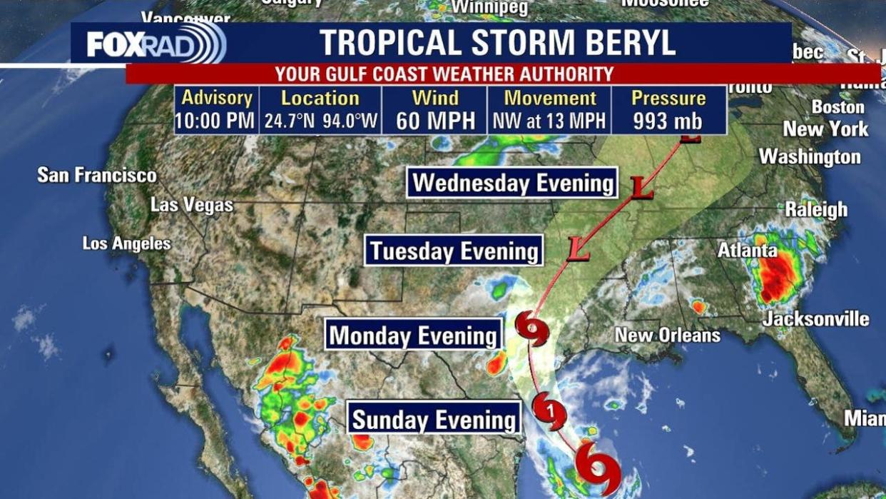
The bottom line is that the NHC still shows it hitting early Monday as a Category 1 hurricane, but we should be alert for a couple of things, especially a sudden strengthening right before landfall. Definitely hope that doesn't happen, but it's possible.
DOWNLOAD THE FOX 26 HOUSTON WEATHER APP BY CLICKING HERE
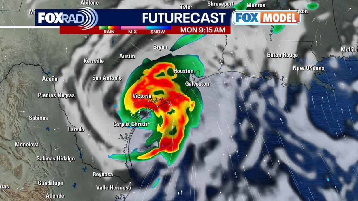
If you live on the coast or on Galveston or Matagorda Bay, be aware that the water level/storm surge could rise up to five feet. Winds will be highly dependent on the exact landfall location and any last minute category changes.
RELATED: Galveston leaders prepare as storm heads to Texas coast
Everyone in most of the FOX 26 area is under a Flood Watch because of the expected 5-10 inches of rainfall with isolated spots getting 12-15 inches.
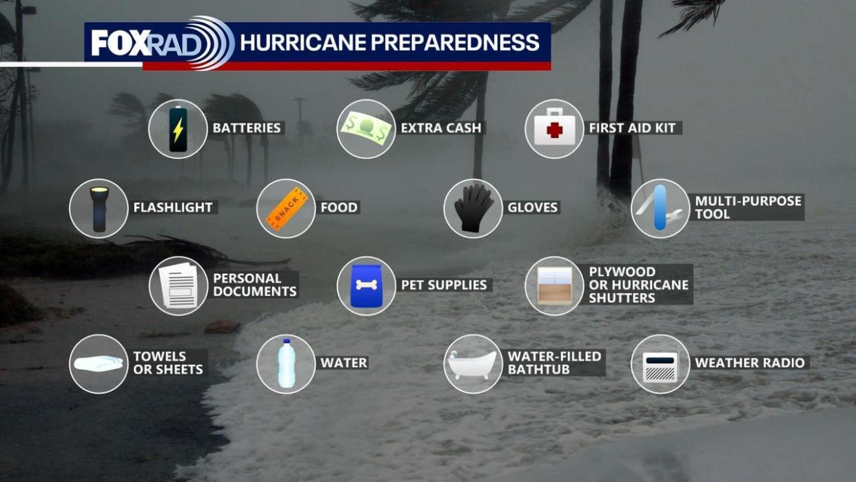
Be ready if the power goes out and make sure to have food, water, medicine, pet food, and other essentials just in case. It is better to be over-prepared than under-prepared.
Sunday should still be relatively quiet, so finish those last-minute preparations and settle in for a stormy Monday.
The FOX 26 Weather Team is closely monitoring developments. They will continue to keep you up-to-date online, on-air, on social media and on FOX Local.
Beryl watches and warnings
HURRICANE WARNING
A Hurricane Warning is in effect for the Texas coast from Baffin Bay northward to Sargent.
HURRICANE WATCH
A Hurricane Watch is in effect for the Texas coast south of Baffin Bay to the mouth of the Rio Grande River, as well as the Texas coast north of Sargent to San Luis Pass.
TROPICAL STORM WARNING
A Tropical Storm Warning is in effect for the Texas coast south of Baffin Bay to the mouth of the Rio Grande River, the Texas coast north of Sargent to High Island, and the northeastern coast of mainland Mexico from Barra el Mezquital to the mouth of the Rio Grande River.
STORM SURGE WARNING
A Storm Surge Warning is in effect for North Entrance of the Padre Island National Seashore to High Island, including Corpus Christi Bay, Matagorda Bay, and Galveston Bay.
STORM SURGE WATCH
A Storm Surge Watch is in effect for the Texas coast from the mouth of the Rio Grande River northward to North Entrance of the Padre Island National Seashore, as well as San Luis Pass to Sabine Pass, including Galveston Bay.
Texas prepares for Beryl
Texans are preparing for Tropical Storm Beryl to make an impact on the coast, and Acting Governor Dan Patrick has expanded the state's disaster declaration to include 81 more counties, bringing the total to 121 counties.
The Texas Division of Emergency Management has raised the readiness level of the State Emergency Operations Center and Texas Emergency Management Council agencies are working around the clock.
Click here to see the list of counties included in the disaster declaration.
Hurricane preparedness list
You should have a disaster preparedness kit ready to go well before a storm is ever on the way. At a minimum, your kit should have the basic supplies like food, water, first aid supplies and flashlights.
Click here to see a list of basic supplies to include in your hurricane preparedness kit.
