Beryl restrengthens into a hurricane hours before Texas landfall
The cyclone strengthened from a tropical storm with winds of 70 mph to a hurricane with sustained winds of 80 mph during the early hours of Monday.

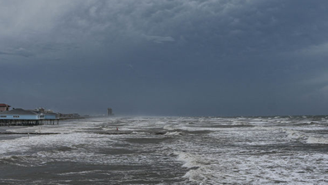
Conditions deteriorating at Surfside Beach, Texas
The full impacts of Hurricane Beryl started to be felt early Monday morning along the Texas coastline.
As of Monday at 3:50 A.M. CT, Hurricane Beryl has made landfall around Matagorda, Texas, blasting life-threatening conditions as power outages surge. Continuous coverage of Hurricane Beryl has moved here.
HOUSTON — Hurricane Beryl is perhaps less than an hour away from making landfall along Texas' Gulf Coast, where it's expected to bring damaging winds, life-threatening storm surge, flooding rains and even the threat of tornadoes.
Torrential rains and hurricane-force gusts have already started battering the Texas coast near where Beryl is heading ashore. Matagorda Bay has clocked a gust of 89 mph with an 85 mph gust measured in Matagorda City.

(FOX Weather)
Meanwhile, a life-threatening storm surge is pushing into the bays and coastlines near Beryl's center.
Storm surge is forecast to reach 3-7 feet in some spots near Beryl, and water was already pushing into the Texas coast and bays along Beryl's approach. Measurements have reached 3.2 feet in Sargent and 2.6 feet in Matagorda Bay as of 2:30 a.m. CT.
"That (storm) surge is just pouring into Treasure Island," said FOX Weather Storm Tracker Mark Sudduth. "You could literally see it pouring in like a raging river right now."
The cyclone strengthened from a tropical storm with winds of 70 mph to a hurricane with sustained winds of 80 mph during the early hours of Monday.

(FOX Weather)
Numerous Hurricane Warnings, Storm Surge Warnings and Tropical Storm Warnings were in effect for the Texas Gulf Coast as the worst of the cyclone bore down on the region.
As the storm moves ashore the coast, rainbands could produce a risk of tornadoes and, because of the potential, a Tornado Watch has been issued for much of the Upper Texas coastline.
"We’re keeping a close eye right now for any waterspouts or tornadoes developing with those outer rain bands," National Weather Service Corpus Christi Meteorologist Eric Forinash said.
The Tornado Watch box includes communities such as Port Arthur, Houston and Galveston.

(FOX Weather)
In addition to the damaging wind threat, a dangerous storm surge and a foot of rain or more are possible through the early half of the week.
A dangerous storm surge of up to 7 feet is expected to impact a wide swath of the Texas coast by Sunday night into Monday, while torrential rains that total as much as 10–15 inches threaten flash and urban flooding – some of which could be considerable. Beryl's powerful hurricane-force winds could lead to power outages and property damage.
![Tides rise and clouds loom overhead Galveston beach just before hurricane Beryl is expected to make landfall on Sunday, July 7, 2024 in Galveston. (Raquel Natalicchio/Houston Chronicle via Getty Images)]() Image 1 of 7
Image 1 of 7Tides rise and clouds loom overhead Galveston beach just before hurricane Beryl is expected to make landfall on Sunday, July 7, 2024 in Galveston. (Raquel Natalicchio/Houston Chronicle via Getty Images) ( )
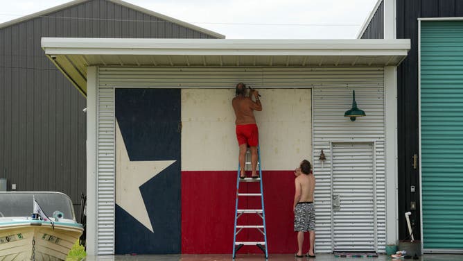
![]() Image 2 of 7
Image 2 of 7Clyde George, left, and his son Chris George board up their home ahead of the arrival of Tropical Storm Beryl on Sunday, July 7, 2024, in Port O'Connor, Texas. (Jon Shapley/Houston Chronicle via Getty Images) ( )
![Tides rise and clouds loom overhead Galveston beach just before Beryl is expected to make landfall on Sunday, July 7, 2024 in Galveston.]() Image 3 of 7
Image 3 of 7Tides rise and clouds loom overhead Galveston beach just before Beryl is expected to make landfall on Sunday, July 7, 2024 in Galveston. (Raquel Natalicchio/Houston Chronicle via Getty Images) ( )
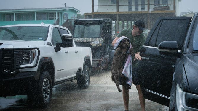
![Black Braun loads his dog Dolly into his family's vehicle as outer bands from Tropical Storm Beryl begin to hit the coast Sunday, July 7, 2024, in Port O'Connor.]() Image 4 of 7
Image 4 of 7Black Braun loads his dog Dolly into his family's vehicle as outer bands from Tropical Storm Beryl begin to hit the coast Sunday, July 7, 2024, in Port O'Connor. (Jon Shapley/Houston Chronicle via Getty Images) ( )
![Surfers on North Padre Island ahead of Hurricane Beryl's landfall in Corpus Christi, Texas, US, on Sunday, July 7, 2024. Tropical Storm Beryl, currently in the Gulf of Mexico, is projected to create storm surge late Sunday and Monday from Corpus Christi to just south of Houston, according to the National Hurricane Center.]() Image 5 of 7
Image 5 of 7Surfers on North Padre Island ahead of Hurricane Beryl's landfall in Corpus Christi, Texas, US, on Sunday, July 7, 2024. Tropical Storm Beryl, currently in the Gulf of Mexico, is projected to create storm surge late Sunday and Monday from Corpus Christi to just south of Houston, according to the National Hurricane Center. Photographer: Eddie Seal/Bloomberg via Getty Images ( )
![Surfers on North Padre Island ahead of Hurricane Beryl's landfall in Corpus Christi, Texas, US, on Sunday, July 7, 2024.]() Image 6 of 7
Image 6 of 7Surfers on North Padre Island ahead of Hurricane Beryl's landfall in Corpus Christi, Texas, US, on Sunday, July 7, 2024. Tropical Storm Beryl, currently in the Gulf of Mexico, is projected to create storm surge late Sunday and Monday from Corpus Christi to just south of Houston, according to the National Hurricane Center. Photographer: Eddie Seal/Bloomberg via Getty Images ( )
![Beryl Set To Regain Hurricane Status On Approach To Texas]() Image 7 of 7
Image 7 of 7A traffic sign on South Padre Island Drive warns drivers ahead of Hurricane Beryl's landfall in Corpus Christi, Texas, US, on Saturday, July 6, 2024. Tropical Storm Beryl, currently in the Gulf of Mexico, is projected to create storm surge late Sunday and Monday from Corpus Christi to just south of Houston, according to the National Hurricane Center. Photographer: Eddie Seal/Bloomberg via Getty Images ( )


KNOW YOUR ZONE: TEXAS HURRICANE EVACUATION ZONES
How much storm surge can be expected along the Texas coast?
A Storm Surge Warning is also in effect from Padre Island to High Island, including Corpus Christi Bay, Matagorda Bay and Galveston Bay.
A Storm Surge Warning means there is a potential for life-threatening water rises within the next 36 hours.

(FOX Weather)
Storm Surge models indicate a water rise of 3–7 feet is possible from Baffin Bay to Sargent, along with Corpus Christi Bay and Matagorda Bay, starting as early as Sunday night and lasting into Monday.
"The deepest water will occur along the immediate coast near and to the right of the center, where the surge will be accompanied by large and destructive waves," the NHC warned. "Surge-related flooding depends on the relative timing of the surge and the tidal cycle and can vary greatly over short distances."
How much rain is expected in Texas from Beryl?

(FOX Weather)
Much of East Texas should brace for several inches of rain from Beryl. Wide swaths of 5-10 inch accumulations, with localized amounts up to 15 inches, are expected across portions of the Texas Gulf Coast and eastern Texas from Sunday through the middle of the week.
"This rainfall is likely to produce areas of flash and urban flooding, some of which may be locally considerable in nature," the NHC warned.
The Houston area is currently forecast to receive 5–8 inches of rain, with heavier amounts in the southern and western suburbs.

(FOX Weather)
Meteorologists with the National Weather Service office in Corpus Christi, Texas, said any of the outer rain bands could also produce tropical storm-force gusts and even spin up an isolated tornado.
Evacuation orders issued for some Texas communities
Cameron County, Texas, was one of the first in the state to issue voluntary evacuations.
Authorities advised those living in mobile homes and visitors staying in parks to seek more substantial shelter.
Nueces County issued similar orders and advised all visitors to leave by Sunday afternoon.
The counties were two of the 40 included in a disaster declaration signed by acting Texas Gov. Dan Patrick.
The Refugio County Office of Emergency Management issued a mandatory evacuation order, telling everyone to leave by 7:30 a.m. Sunday.
"Please take precautions to get your family and pets out of the county to a safe location," the order stated.

Rough waves impact Texas coastline ahead of Beryl's landfall
The National Hurricane Center expected a storm surge of 5-7 feet south of Galveston, Texas.
Texas Gov. Greg Abbott is currently out of the country but is monitoring the situation.
Communities in low-lying areas and along the coast have already started to offer sandbags to residents, which will be available as long as supplies last.