Antrodoco (Q223434)
Italian comune
| Sprache | Label | Description | Also known as |
|---|---|---|---|
| Englisch | Antrodoco |
Italian comune |
Statements
2,570
1 January 2017
1 reference
2,498
1 January 2018
1 reference
Popolazione Residente al 1° Gennaio 2018 (Italian)
16 March 2019
63.9 square kilometre
9 October 2011
2 references
Superficie di Comuni Province e Regioni italiane al 9 ottobre 2011 (Italian)
16 March 2019
02013
0 references
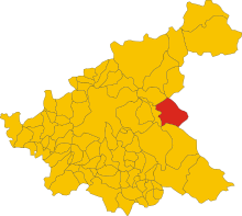
Map of comune of Antrodoco (province of Rieti, region Lazio, Italy).svg
5,887 × 5,279; 121 KB
5,887 × 5,279; 121 KB
0 references
0746
0 references
RI
0 references
Antrodoco
0 references
Identifiers
Sitelinks
Wikipedia(49 entries)
- azbwiki آنترودوکو
- bclwiki Antrodoco
- bgwiki Антродоко
- cawiki Antrodoco
- cebwiki Antrodoco (munisipyo)
- cewiki Антродоко
- dewiki Antrodoco
- enwiki Antrodoco
- eowiki Antrodoco
- eswiki Antrodoco
- euwiki Antrodoco
- fawiki آنترودوکو
- frwiki Antrodoco
- hawiki Antrodoco
- huwiki Antrodoco
- hywiki Անտրոդոկո
- iawiki Antrodoco
- itwiki Antrodoco
- jawiki アントロドーコ
- kowiki 안트로도코
- lawiki Interocrium
- lbwiki Antrodoco
- lijwiki Antrodoco
- lldwiki Antrodoco
- lmowiki Antrodoco
- mswiki Antrodoco
- napwiki Antrodoco
- nlwiki Antrodoco
- plwiki Antrodoco
- pmswiki Antrodoco
- ptwiki Antrodoco
- roa_tarawiki Antrodoco
- rowiki Antrodoco
- ruwiki Антродоко
- scnwiki Antrodocu
- shwiki Antrodoco, Rieti
- srwiki Антродоко
- svwiki Antrodoco
- tlwiki Antrodoco
- trwiki Antrodoco
- ukwiki Антродоко
- uzwiki Antrodoco
- vecwiki Antrodoco
- viwiki Antrodoco
- vowiki Antrodoco
- warwiki Antrodoco
- zh_min_nanwiki Antrodoco
- zhwiki 安特罗多科
Wikibooks(0 entries)
Wikinews(0 entries)
Wikiquote(0 entries)
Wikisource(0 entries)
Wikiversity(0 entries)
Wikivoyage(1 entry)
- itwikivoyage Antrodoco


