Live updates for Hurricane Beryl: Flood advisory for Corpus Christi
The Caller-Times will be providing live updates about Hurricane Beryl as news comes out about the storm.
No damages reported as of Monday morning | Updated 9:20 a.m.
A damage assessment overview provided by the city of Corpus Christi shows little-no-no impacts from Tropical Storm Beryl as of early Monday morning, and assessments by emergency personnel have ended.
Winds in Corpus Christi did not exceed 44 miles per hour, according to the one-page brief.
That speed is much lower than during some other storms Corpus Christi has faced – and a step down the uppermost ceiling of 50 mph that had been predicted for overnight.
One inch of rain was the highest recorded, the document states.
No flooding was observed on North Beach or Laguna Shores, according to the brief.
Both areas are well know as vulnerable to flood risks.
Personnel from the Parks and Recreation Department are evaluating municipal parks and the gulf-facing beaches, the document states.
Worst of the weather has passed, marine hazards remain | Updated 8:30 a.m. Monday
Corpus Christi is no longer under a tropical storm warning; however, a coastal flood advisory remains in place through Tuesday morning with three feet of beach inundation expected, according to messages posted by the local office of the National Weather Service.
The latest update – issued at about 4 a.m. on the agency’s social media X account— shows a small craft advisory anticipated to be in effect through this afternoon.
Winds are projected to reach 34 knots, or nearly 40 mph, and seas may peak as high as 10 feet this morning, according to NWS.
Tropical storm and storm surge warnings remain in effect north of Corpus Christi, including in Victoria and Calhoun counties, a map shows.
Tropical storm warning | Updated 9 p.m.
A hurricane warning for Corpus Christi has now been downgraded to a tropical storm warning, anticipated to remain in effect through Monday afternoon, according to social media posts by the local office of the National Weather Service.
Also downgraded is a storm surge warning for the city, replaced with a coastal flood advisory forecasting one-foot inundation of beaches, the posts show.
Highest likelihood of weather threats | Updated 6 p.m.
The highest storm surge and wind speeds in Corpus Christi will likely materialize between 8 p.m. Sunday and 4 a.m. Monday, according to a news release issued by city officials.
Gusts associated with Tropical Storm Beryl– forecast to make landfall far north of Corpus Christi – are predicted to potentially reach as high as 40 mph within the urban city and as high as 50 mph in the city’s coastal areas, the email states.
“Residents are advised to stay indoors and secure outdoor objects to prevent damage,” city officials wrote in the news release.
The local office of the National Weather Service posted on social media late Sunday graphics indicating the threat of significant damaging winds – as well as flooding rain – exists but is limited.
Corpus Christi’s coastline remains under a hurricane warning, according to the local NWS’ 4 p.m. bulletin, while a tropical storm warning is in effect for inland areas.
“Emergency services are prepared to respond to any incidents, but community cooperation is crucial,” the city’s news release states. “Please heed all warnings and advisories issued by local authorities.”
Acting Governor drives home message, 'Turn Around, Don't Drown' | Updated 3:30 p.m.
Acting Gov. Dan Patrick and Texas Emergency Management Chief Nim Kidd provided an update on the state's preparedness and response efforts ahead of impacts from Tropical Storm Beryl on Sunday afternoon, reminding Texans to listen to local officials in preparing for impending wind, rain and flooding.
He urged Texans and visitors to the state to take the storm seriously, heed the warnings of local meteorologists and officials and to be prepared.
"This storm is predicted right now by the National Hurricane Center to land somewhere between Corpus Christi and Galveston Island," he said. "If you’re at Galveston, you may say it’s down in Corpus. If you’re in Corpus, you're saying, 'Gee, it’s going right here. This can change and very often will change as we’ve seen from past storms.'"
Kidd said that the first tropical storm-force winds will line up along the Texas coast in about 6 hours, and advised people to make their final preparations now.
"There will be power outages," he said. "Now is the time to make sure that all of your devices are charged up.
"Please do not drive through water," Kidd stressed.
TDEM, which has been preparing for the storm for the past week, Patrick said, is now working in cooperation with state agencies and local partners to pool resources to initiate recovery efforts once the tropical storm makes landfall, including clearing debris and repairing power outages.
"We've encouraged our local partners to check in with their debris contractors," Kidd said. "The faster we get debris cleaned up, the faster we get on the road to recovery. For you personally, it's not too late to make sure you have all of the documents your insurance company is going to require."
The agency has been in contact with county judges and their emergency management teams along the Texas coast, with TDEM staff prepared to help in emergency operation centers. Search and rescue teams and emergency medical support are also on hand to help people who require electricity for lifelines at their homes.
According to the USA TODAY outage tracker, roughly 11,000 power outages have been reported in Texas, including more than 3,300 in Angelina County, where the National Weather Service said they'd been alerted by law enforcement to trees down on power lines at about 2:30 p.m. in Burke, in Angelina County and in Hudson around the same time.
On July 7, AEP Texas published a news release stating that more than 4,500 AEP Texas and contract personnel have been activated in the past few days from around Texas and neighboring states to respond to the storm, with about 2,700 resources to be positioned on Sunday in areas predicted to be affected by the storm, including service areas along the coast, with high emphasis on the upper Corpus Christi District. Incoming resources are checking in to primary gateway staging areas located in Robstown before deploying to assignments.
Additional TDEM response efforts include:
Staff support to local Emergency Operations Centers and staging areas
Communications with 911 call centers, cellular service providers, amateur radio operators and satellite communications
Coordination with Texas A&M University Forest Service all-hazard stripe teams and Texas A&M Agrilife Extension Service
Coordination with Animal Health Commission to protect livestock and equipment, address animal shelter issues
Incident management teams and saw crews to help with debris cleanup
Texas Commission on Environmental Quality staff ready to support water, wastewater and public drinking systems
Texas Department of Transportation Road Crews ensuring all transport lanes and storm drains open; Texas DOT ready to assist in motorist evacuation
Texas Department of Information Resources securing cybersecurity systems
Texas Department of Public Safety Highway Patrol aircraft and marine units
Texas Parks and Wildlife game wardens and state park police
Support from volunteer organizations trained in disaster relief -- American Red Cross and Salvation Army
CCRTA service changes | Updated 2:30 p.m.
The Corpus Christi Regional Transportation Authority is adjusting or temporarily suspending some of its regular routes based on potential impacts of Tropical Storm Beryl, according to a news release sent Sunday afternoon.
In the email, officials wrote that the following routes will not be available Monday:
“▪Route 65 (Padre Island Connection)
▪Route 90 (Flexi-B)
▪Route 94 (Port Aransas Shuttle)
▪Route 95 (Port Aransas Express)”
Several other routes may have shortened hours, in service until noon “with weather conditions being monitored and services being suspended if required,” according to the news release.
As shown in the email, those are:
“▪Route 54 (Gregory/Downtown Express)
▪Route 76 (Harbor Bridge Shuttle)
▪Route 78 (North Beach).”
City of Corpus Christi readiness level downgraded | Updated 2:15 p.m.
City officials do not plan to expand Corpus Christi’s emergency operations center at 6 p.m. “but will continue it at 6 p.m. under limited operations having representatives from Fire, Police, Public Works, IT and Communications,” wrote City Manager Peter Zanoni in a message to the Caller-Times.
“The EOC will be activated in this limited stance thru the overnight,” he added.
The city’s readiness level has dropped from a level 2 – “an emergency exists which is very likely to occur” – to a level 3, which is “existence of a situation that may develop into an emergency but not an imminent threat,” Zanoni wrote.
At Corpus Christi International Airport, some flights that had been scheduled for Sunday and Monday have been canceled, he wrote.
“We encourage all persons flying out of CCIA to check flight status with the carriers,” Zanoni added.
Texas State Aquarium to reopen | Updated 2:15 p.m.
The Texas State Aquarium plans to reopen Monday as “our area will not experience hurricane conditions or significant storm surge,” a news release sent early Sunday afternoon states.
"We are relieved and excited to welcome our visitors back to the Aquarium," stated Jesse Gilbert, President and CEO at the Texas State Aquarium, in the email. "Our top priority has always been the safety of our guests, staff, and animals, and we are grateful that our city has been spared from the severe impacts of Hurricane Beryl."
National Hurricane Center issues new bulletin | Updated 1:50 p.m.
Corpus Christi remains under a hurricane warning as part of a stretch between Baffin Bay and San Luis Pass, according to the National Hurricane Center’s 1 p.m. update.
It forecasts Tropical Storm Beryl will become a hurricane before landfall.
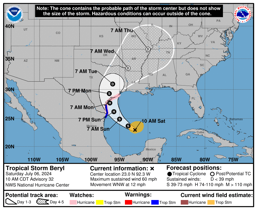
Corpus Christi is not shown in the cone of uncertainty, which is now focused north of the city.
The track of the storm is advancing in a north and northwestward direction, according to the agency.
“This general motion is expected to continue through tonight, with a turn toward the north forecast on Monday,” states a 1 p.m. bulletin posted on the NHC’s website. “On the forecast track, the center of Beryl is expected to make landfall on the middle Texas coast early Monday. Beryl is forecast to turn northeastward and move farther inland over eastern Texas and Arkansas late Monday and Tuesday.”
The status of the city of Corpus Christi | Updated 1:10 p.m.
The city of Corpus Christi is anticipated to resume normal business operations Monday, according to a message from City Manager Peter Zanoni to the Caller-Times.
It is expected that the potential risks to Corpus Christi are storm surge, wind gusts between 40 mph and 50 mph, and isolated tornadoes, wrote Zanoni following a briefing with the local office of the National Weather Service.
Storm surge in Corpus Christi along the the Gulf of Mexico coastline is anticipated to see inundation between three to five feet, and about one to three feet in the bays, he added.
Areas at risk for potential inundation include the city’s downtown marina, North Beach, Flour Bluff and Laguna Shores Boulevard, according to Zanoni’s message.
Corpus Christi Medical Center services | Updated 12:45 p.m.
Medical services at several Corpus Christi medical centers will resume within the next day, according to a news release.
The email sent Sunday follows an announcement Saturday that three locations would be temporarily suspended.
The following locations will reopen at these scheduled times, according to the news release:
• ER 24/7 Northwest in Corpus Christi reopens 6 p.m. Sunday
• ER 24/7 in Rockport reopens 9 a.m. Monday
• ER 24/7 Portland reopens 9a.m. Monday
The hospital system’s other locations at Corpus Christi Medical Center Doctors Regional, Corpus Christi Medical Center Bay Area and Corpus Christi Medical Center Bayview did not suspend services and have remained open, the email states.
Weather forecast according to meteorologist | Updated 11:35 a.m.
Gusty winds could reach 40 to 60 mph, and up to 70 mph in some areas that are near water, according to AccuWeather Meteorologist Alex DaSilva.
While the city will miss the brunt of the storm, the outer rain bands approaching from the east will likely continue into Sunday afternoon and overnight, with periodic downpours and possible thunderstorms sweeping through with the outer rain bands, DaSilva said.
With the storm track trending northward in the last two days, he predicted 1 to 2 inches of rain would fall in the Corpus Christi area and between 4 to 8 inches eastward toward Port LaVaca.
Storm surge is predicted at 1 to 3 feet for the entire Texas coast, though it could be as high as 6 feet for Galveston and Matagorda bays due to their proximity to where the storm is forecast to make landfall.
New NWS forecasts | Updated 9:50 a.m.
Some of the first rain bands from Tropical Storm Beryl are beginning to move into Corpus Christi and the surrounding areas, according to the Corpus Christi office of the National Weather Service.
As of 9:30 a.m., radar showed clouds pulling toward land from a span reaching from Brownsville on the Texas-Mexico border up to Beaumont in East Texas.
“Rain bands from Beryl will gradually spread across the area through the day today,” according to an NWS message posted on its social media account. “Gusty winds, heavy rain, and isolated tornadoes will be possible as they pass through.”
Forecasts early Sunday morning show another small predicted shift to the east, an NWS post states.
In messages on the agency’s X (formerly Twitter) account, landfall is forecast to make its arrival somewhere along the middle- to upper-coast of Texas around 1 a.m. Monday.
Although Beryl remains categorized as a tropical storm, meteorologists are predicting it to grow to a Category 1 hurricane status by landfall.
Tropical storm-force winds range from 39 and 73 mph sustained, while Category 1 storms carry sustained winds between 74 and 95 mph.
“Preparations should be rushed to completion before tropical storm conditions begin late today,” according to an NWS’ online weather statement.
It’s anticipated that potential tropical storm conditions will descend this afternoon, with winds reaching hurricane force tonight, according to the agency’s posts.
Corpus Christi is now shown outside the cone of uncertainty. However, meteorologists have emphasized that danger is present outside the cone.
Hurricane warnings remain in effect for the coastlines of Baffin Bay to Brazoria County, NWS maps show.
There is a limited threat of tornadoes in the area, the NWS graphic states. Beaches remain hazardous with potential coastal flooding and rip current risks.
Several structures on North Padre Island have been boarded up as of this morning, including at least one popular tourist shop. Rain started as of about 9:30 a.m.
Beryl projected for mid-Texas coast | Updated 1 a.m.
The National Hurricane Center's latest projection for Beryl's path continued to show an expected landfall along the mid-Texas coast early Monday, with tropical storm-force winds anticipated in the Corpus Christi area by Sunday evening.
The National Weather Service office in Corpus Christi shared a brief summary of projections for Beryl as of the overnight hours Saturday into Sunday.
"Beryl remains a 60 mph tropical storm over the western Gulf of Mexico and is expected to make landfall by Monday morning somewhere along the mid Texas coast as a Category 1 Hurricane, though you should still be planning for a Category 2. Most likely time of arrival of TS force winds is Sunday Evening. Dangerous rip currents/tidal runup along the coast will continue through the Holiday Weekend. Storm Surge and Seas will increase on Sunday as the storm approaches. Potential for widespread heavy rain, especially Sunday night into Monday. Flash flood and river flood threat continues, mainly across the Victoria Crossroads. Threat for scattered tornadoes exists as well."
TAMUCC to barricade campus, USS Lexington to close during storm | Updated 9 p.m.
In accordance with Texas A&M University-Corpus Christi's hurricane preparedness plan, the University Police Department will begin placing barricades at all main entrances to campus at noon Sunday.
While the barricades are up, access to campus is restricted. Only those with Tier 1 status on the university's Incident Command team will be allowed to enter. The institutions will announced when the barricades are removed.

TAMUCC anticipates shifting back to in-person work and classes on Tuesday.
Following suit of the Texas State Aquarium, the USS Lexington Museum will be closed Sunday and Monday. Hours for Tuesday are to be determined, pending the impact of Tropical Storm Beryl.
Port Aransas ferry, additional closings | Updated 7:35 p.m.
The Texas Department of Ferry Operations has notified Port Aransas that ferry operations will be suspended at noon Sunday due to storm impacts from Tropical Storm Beryl. Those planning to leave Port Aransas should expect significant delays and plan accordingly.
Personnel from the Coastal Bend Food Bank announced on Facebook Saturday that it would be closed on Monday. The mobile distribution scheduled for Tuesday has been postponed. The Coastal Bend Food Bank is closely monitoring the weather, and will update neighbors of a future distribution date and time to continue meeting the needs of the community, the post said.
Life-threatening storm surge warning | Updated 4:20 p.m.
The Storm Surge Unit at the National Hurricane Center released an emergency alert to Texans Saturday afternoon. A Storm Surge Warning is in effect for the Coastal Bend area for life-threatening flooding.
The warning is issued up to 36 hours before hazardous conditions begin.
The threat is focused on the north entrance of the Padre Island National Seashore to San Luis Pass, southwest of Galveston. Residents in the area should follow any advice given by local officials and follow evacuation orders.
As of 4 p.m. Saturday, Beryl is forecast to bring damaging hurricane-force winds to portions of the lower and middle Texas coast late Sunday night and Monday. A Hurricane Warning was given to residents from Baffin Bay to Sargent.
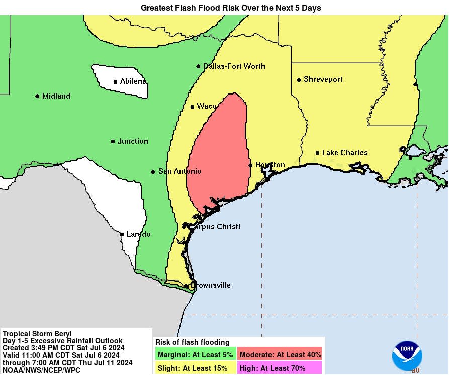
Flash and urban flooding, some of which may be considerable, are likely across portions of the Texas Gulf Coast and eastern state beginning late Sunday through the middle of next week. River flooding is also possible.
Rip currents will cause life-threatening beach conditions through the weekend across much of the Gulf Coast. Beachgoers should heed warning flags and the advice of lifeguards and local officials before venturing into the water.
The Port of Corpus Christi increased its Hurricane Readiness Status to Hurricane Readiness Level 1, in accordance with its 2024 Hurricane Readiness Plan.
The USCG Captain of Sector Port Corpus Christi (CoTP) has set Port Condition Yankee from the Colorado Locks to the U.S. Mexico border, including the Port of Corpus Christi, effective 2 p.m. Saturday. Under this condition, all vessel movement and cargo operations are restricted.
The Texas State Aquarium announced Saturday it will be closed Sunday and Monday due to the anticipated impact of Beryl.
The aquarium activated its Emergency Operations Center, staffed by essential personnel including animal care specialists, water quality experts and operations staff. The team members will remain onsite to ensure the safety and well-being of the more than 300 species that reside there and to maintain critical life support systems and habitats.
Additionally, the Aquarium’s Wildlife Response Operation Center will be on standby to respond to any wildlife affected by the storm.
As well, all trash and recycling collections scheduled for Monday in Corpus Christi will be rescheduled for Tuesday. The operating hours of the J.C. Elliott Transfer Station and Collection Center have been extended until 8 p.m. for Saturday.
Refugio County orders mandatory evacuation | Updated 3:50 p.m.
In a Facebook post, Refugio County Judge Jhiela "Gigi" Poynter announced a mandatory evacuation for citizens in the area.
Poynter said residents can expect heavy traffic exiting the area. City water will eventually be turned off to prevent further damage during the storm.
The county will be providing busses to emergency shelter locations outside of town for those unable to evacuate. People in need of assistance to evacuate are asked to call 361-526-2820 and leave a message.
Nueces County Judge puts out voluntary, mandatory evacuation | Updated 2:50 p.m.
In a release, Nueces County Judge Connie Scott put out a voluntary evacuation for visitors. Tourists are "strongly encouraged" and "urged" to evacuate Nueces County and the surrounding areas immediately, as of Saturday.
On Sunday, a mandatory evacuation for visitors goes into effect. Visitors must evacuate by noon Sunday.
Area residents who chose not to evacuate are asked to take necessary precautions to protect lives and secure property.
Corpus Christi Medical centers preparing for Beryl | Updated 2:30 p.m.
Corpus Christi Medical Center Doctors Regional, Bay Area and Bayview will remain open for the community during Tropical Storm Beryl.
At 6 p.m. Saturday, ER 24/7 Rockport, ER 24/7 Northwest and ER 24/7 Portland will be temporarily suspended.
Port Aransas puts out mandatory visitor evacuation | Updated 2:10 p.m.
In a release, the city of Port Aransas said it is keeping a close eye on Tropical Storm Beryl, which has not changed course as of 2 p.m. Saturday.
Port Aransas officials set a mandatory visitor evacuation set for noon Sunday, meaning all visitors are expected to be out of the tourist town then. This also includes short-term RV visitors.
As well, citizens in low-lying areas in Port Aransas are encouraged to evacuate.
Beryl makes slight turn northwest, Mayor Guajardo declares State of Disaster | Updated 11:20 a.m.
Corpus Christi Mayor Paulette Guajardo declared a Local State of Disaster for the Sparkling City by the Sea in response to the potential impending weather conditions expected from Tropical Storm Beryl.
The declaration aligns with Gov. Greg Abbott's severe disaster weather declaration for 40 counties, including Nueces County, ensuring resources are available for communities in need. The declaration went into effect immediately Saturday and will continue for a period of no more than seven days.
Tropical Storm Beryl is continuing on a west-northwestward track over the southwestern Gulf of Mexico at around 12 miles per hour, but has started to move more northwesterly. The storm is expected to restrengthen into a hurricane late Sunday night into Monday before making landfall between Baffin Bay and Sargent midday Monday, according to the National Weather Service of Corpus Christi.
Hurricane warnings will likely start Saturday afternoon around 4 p.m.
A Tropical Storm Watch is in effect for Calhoun and Refugio counties, and Tropical Storm Warnings are in effect for the lower Texas coast south of Baffin Bay.
On Saturday, Ingleside and Gregory-Portland school districts both announced all campuses and offices will be closed Monday due to the future weather. As well, the South Texas Botanical Gardens & Nature Center will close Sunday and Monday.
The Texas State Aquarium and its Wildlife Rescue Center are preparing for the anticipated impacts of Beryl. The aquarium will deploy flood control devices Sunday to protect the site from storm surges and outdoor animals will be relocated Sunday evening to ensure safety.
Beryl expected to make landfall Monday along Texas coast | Updated 8:30 a.m.
The National Weather Service of Corpus Christi reported that Beryl, now a tropical storm, is continuing to move over the southwest Gulf of Mexico and is expected to land Monday morning somewhere along the mid-Texas coast as a Category 1 Hurricane. Though people should plan and prepare for a Category 2.
Some uncertainty about the exact strength and track Beryl will take is still at play, but an eastward trend continues.
Texans should start to expect tropical storm force winds anywhere from Sunday morning to Sunday evening. Dangerous rip currents will continue through the weekend and storm surge will begin to increase later in the weekend.
The Coastal Bend should expect potential widespread heavy rain, especially Sunday night and Monday. The threat for isolated tornadoes exists as well.
Beryl path keeps moving eastward | Updated 1 a.m.
The National Hurricane Center's latest projection for Beryl's path showed an expected landfall along the mid-Texas coast early Monday.
The National Weather Service office in Corpus Christi shared a brief summary of projections for Beryl as of the overnight hours Friday into Saturday.
"Beryl continues moving over the Southwest Gulf of Mexico this evening and is expected to make landfall Monday morning somewhere along the mid Texas coast as a Category 1 Hurricane, though plan for a Category 2. Still some uncertainty with the exact strength and track Beryl will take, but an eastward trend in the guidance continues. Earliest reasonable time of arrival of TS force winds is Sunday morning. Most likely time is Sunday night. Dangerous rip currents/tidal runup along the coast will continue through the Holiday Weekend. Storm Surge and Seas will begin to increase starting later this weekend. Potential for widespread heavy rain, especially Sunday night and Monday. Flash flood and river flood threat continues, mainly across the Coastal Bend, Coastal Plains, and Victoria Crossroads. Threat for isolated tornadoes exists as well."
Port of Corpus Christi raises readiness to level 2 | Updated 6:10 p.m.
The Port of Corpus Christi has reached a Level 2 in its hurricane preparation, according to a news release issued by the agency late Friday.
“Under this condition, owners, operators or agents of all self-propelled oceangoing vessels over 500 gross tons, all barges and their support tugs should review USCG plans to depart or remain in port,” officials wrote.
Hurricane, storm surge watches issued | Updated 4:30 p.m.
The National Weather Service Corpus Christi issued storm surge and hurricane watches for the Corpus Christi area Friday just before 4 p.m.
A storm surge watch means life-threatening inundation from rising water moving inland from the coastline is possible sometime within the area within the next 48 hours.
A hurricane watch means hurricane-force winds are possible somewhere within the area within the next 48 hours.
More: Hurricane watches, warnings and evacuations: What to do when one is declared
Locations affected by the storm surge and hurricane watches include Corpus Christi, Flour Bluff, Chapman Ranch, Agua Dulce, Banquete, Bishop, Driscoll, Petronila, Robstown, Mustang Island, Port Aransas, Ingleside, Portland, Kingsville, Loyola Beach and Riviera.
Hurricane watches extend in coastal areas and storm surge watches in inland areas. For a full list of watches and details about specific locations visit the National Weather Service Corpus Christi website at https://forecast.weather.gov/wwamap/wwatxtget.php?cwa=CRP&wwa=storm%20surge%20watch.
The latest local forecast predicts tropical storm or Category 1 hurricane winds Monday, as well as the potential for three to five feet of storm surge in surge-prone areas. Peak rainfall could be 4 to 8 inches, with locally higher amounts. Forecasts vary by location.
According to the watches, residents should plan for life-threatening wind the equivalent of a Category 1 or Category 2 hurricane and prepare for considerable wind damage and flooding.
Forecast shows increased threat | Updated 2:30 p.m.
Although it is currently projected to make landfall in South Texas as a Category 1 hurricane, Coastal Bend residents should be making preparations for Hurricane Beryl to reach a Category 2 strength, according to messages by the local office of the National Weather Service.
A Category 1 storm has wind speeds ranging from 74 mph to 95 mph, while wind speeds of a Category 2 hurricane span 96 mph to 110 mph.
“Conditions could begin to deteriorate Sunday night into Monday,” meteorologists wrote in social media posts Friday. “Now would be the time to prepare.”

Like all forecasts generated within days of an event, there isn’t certainty on some of the details residents typically want to know most – the size and strength of the storm, and where and when it will make approach land.
Hurricane Beryl’s forecast trajectory, however, is continuing to point north toward the Texas coastline, NHC and NWS graphics show as of 2 p.m.
It is currently estimated that the storm will arrive late Sunday or possibly Monday morning, according to a series of graphics and messages on the local NWS X social media site.
Tropical storm force winds – which range in speed between 39 and 74 mph – are anticipated to make it to the Coastal Bend sometime Sunday, according to forecasts.
Beaches are expected to be hazardous , with the threats of coastal flooding and rip currents, officials have said.
There is “potential for widespread heavy rain, especially Sunday night into Monday,” meteorologists wrote Friday, adding that “flash flood and river flood threat continues to increase,” including in the Coastal Bend.
As of 10 a.m. Friday, the National Hurricane Center’s rain map showed the Corpus Christi area of receiving between four and six inches of rain through Wednesday.
Schools, events postponed | Updated 11 a.m.
Gregory-Portland ISD will cancel all student activities scheduled for Monday and district staff will not report to work. All offices and campuses will be closed Monday. The school district will provide another update on Monday.
Ingleside ISD will close all district operations, offices and campuses on Monday. District officials will continue to monitor the weather to determine operations for Tuesday.
Corpus Christi ISD will cancel summer school classes for Monday. Employees do not need to report to work on Monday and all buildings will be closed.
West Oso ISD will cancel all student activities planned for Monday, including the ACE Summer Program and athletic programming. As of Friday evening, a final decision has not been made about staff reporting for Monday.
Del Mar College will be closing its campuses on Monday, with Summer 2 classes starting once the college reopens.
Texas A&M University-Corpus Christi will shift to remote work and classes Monday. Texas A&M University-Kingsville will suspend normal operations Monday. Classes, both online and in-person, are canceled for Monday for Kingsville college students.
Luis Purón, executive director for the Rockport Center for the Arts, announced Friday the 56th annual Rockport Art Festival has been shortened to just a one-day event this year due to Hurricane Beryl. The event will start at 10 a.m. Saturday.
Nueces County facilities will be closed Monday, Nueces County Judge Connie Scott announced during a press conference on Friday afternoon. All jury duty assignments for that day will be rescheduled, and assignees will be notified.
County, city provide update to residents
"We are paying attention to this storm," Judge Connie Scott announced from the podium in the Nueces County Commissioners Courtroom during a news conference held at about 3 p.m. on Friday. "We have been working closely and participated in conference calls with TDEM, the National Weather Service and many organizations.
"We continue and will continue to watch and to monitor this storm very closely and will keep you informed as information becomes available," the judge said.
The county is advising citizens who live on the water or in low-lying areas that are prone to flooding or who are visiting in recreational vehicles to consider evacuating the area sooner rather than later. Local citizens are encouraged to begin making preparations to secure their property and follow their normal plans for hurricane preparedness.
Residents are encouraged to follow NWS Corpus Christi, visit nuecesco.com or the Nueces County Facebook page for further alerts. They can sign up for the city's Reverse Alert by texting BEREADYCCNC to 888777 to sign up by text and receive the latest notices about the storm.
In additional preparation efforts, units are staging at the Richard M. Borchard Regional Fairgrounds in Robstown, with AEP providing out-of-state bucket trucks and AT&T units. The Texas Commission on Environmental Quality will also offer search and rescue boats, and 24 ambulances will be parked to help evacuate, if necessary, with generators provided by HEB on hand, she said.
Corpus Christi Mayor Paulette Guajardo, Corpus Christi Fire Department Chief Brandon Wade, Corpus Christi Police Department Chief Mike Markle and other city leaders held a press conference at City Hall Friday afternoon to discuss precautions residents should take.
"Beryl is expected to make landfall as a potential Category 1 hurricane; however, South Texas is being encouraged for a Category 2 hurricane," Guajardo said. "We want to ask anyone who is visiting our city to consider returning at an earlier time."
Guajardo said the Gov. Greg Abbott reached out to her Friday morning to "ensure the state of Texas' support for Corpus Christi is there."
Wade said the city has been tracking Beryl since last Friday. He said Corpus Christi is coordinating with state agencies to be sure they are taking the necessary precautions.
"Our Emergency Operation Center will be activated for this event," Wade said. "We're taking this very seriously and asking the community to take it serious as well."
Wondering if you should board up your windows? Wade said if you want to, board them up.
"It would be best to do so, but play it by ear," Wade said. "It's not wrong to be precautious."
Corpus Christi Regional Transportation Authority prepared
In the case of an evacuation, the CCRTA is ready.
In a release, Chief Executive Officer Derrick Majchszak said he will lead his staff and proceed with evacuating the community.
“Once an evacuation order is declared, all transportation becomes fare-free to transfer stations, where evacuees are then transported to the Corpus Christi Gym and Natatorium or the Richard Borchard Fairground," Majchszak said. "From those central points, evacuees are then transported to a safe location."
Individuals utilizing the city buses during an evacuation may bring luggage, essential items and/or pets with them for travel. It is preferred that pets are in carriers, as they must be controlled and not a safety risk to fellow passengers.
Coastal Bend beaches
Padre Island National Seashore began implementing a phased hurricane shutdown process Friday, immediately closing vehicle access to North Beach, South Beach and Yarborough Pass.
Malaquite Campground, Bird Island Basin Campground and the Malaquite Visitor Center will close starting noon Saturday. A full park closure will take place staring at 12 a.m. Sunday.
Mustang Island State Park plans to remove beach amenities Saturday, including beach access mats, picnic tables and Port-O-Can facilities Saturday.
Kleberg County, Kingsville community prepares
Kleberg County Judge Rudy Madrid called for a voluntary evacuation of low lying areas including Loyola Beach and Baffin Bay on Thursday.
According to a city of Kingsville news release Thursday, both Kleberg County and Kingsville distributed sandbags Friday.
The FEMA domes at H.M. King High School in Kingsville will be open Saturday for anyone who needs a safe space to go for the storm. For transportation assistance, call 361-455-8686.
The JK Northway Exposition Center RV grounds in Kleberg County will also be open for free for RV residents. The stables behind JK Northway RV grounds are available to shelter livestock, according to the news release.
More: Here's where you can see full coverage of hurricanes and other storms in the Coastal Bend.
More: Hurricane Beryl tracker: Maps show storm's projected path as it heads toward South Texas
This article originally appeared on Corpus Christi Caller Times: Hurricane Beryl: Live updates for Texas Coastal Bend, Corpus Christi

