Something local for my first entry
Users' Diaries
Recent diary entries
شارع عين الهاشمي شريوف
شريوف
Zannat Street

area fix
Todo
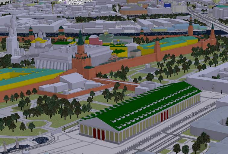
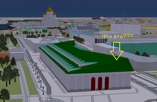
Posted by Zkir on 27 September 2024 in Russian (Русский).
Last updated on 30 September 2024.

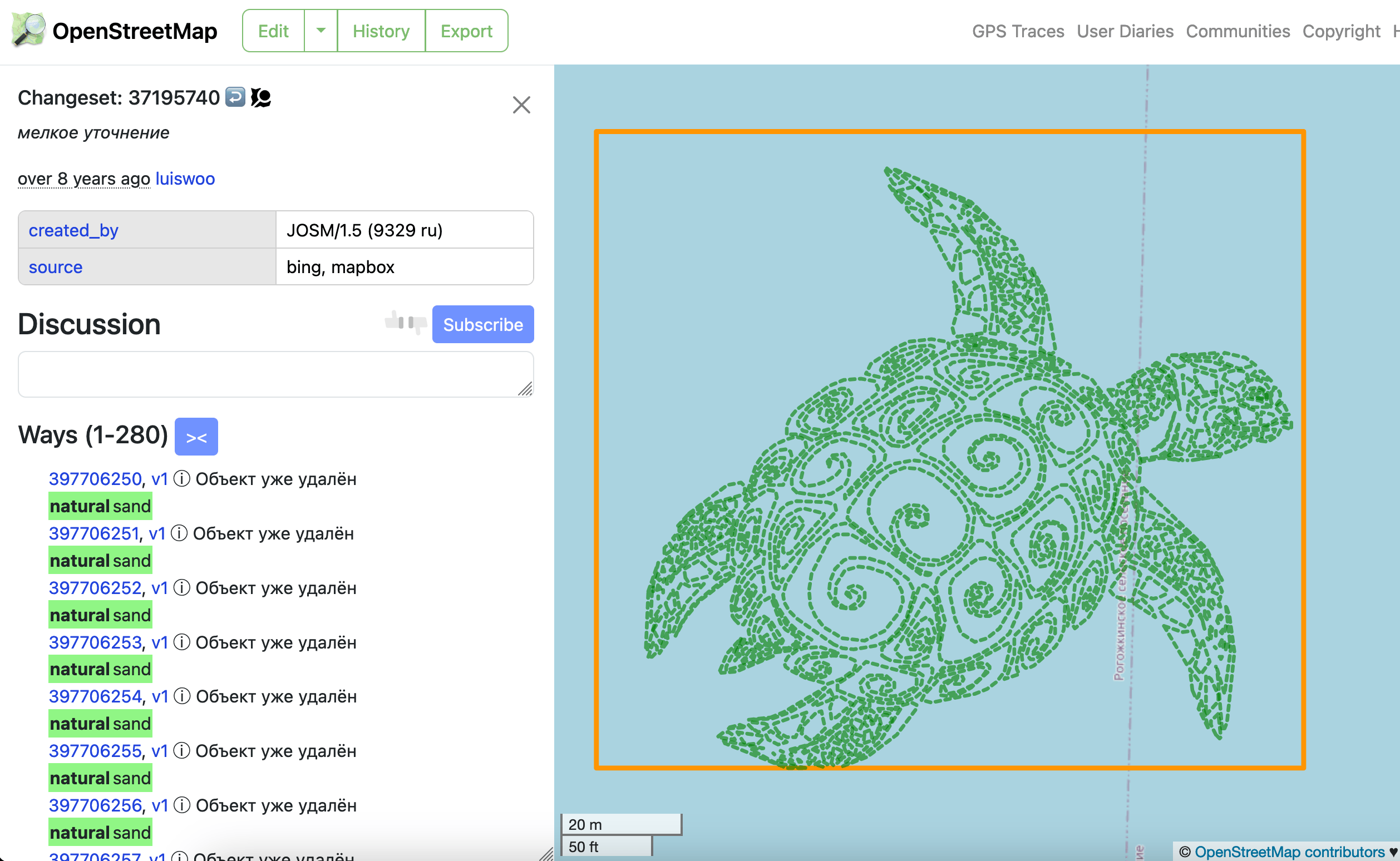
Я очень горд собой, я перепилил Московский манеж. :”) Как никак это один из наших архитектурных шедевров.
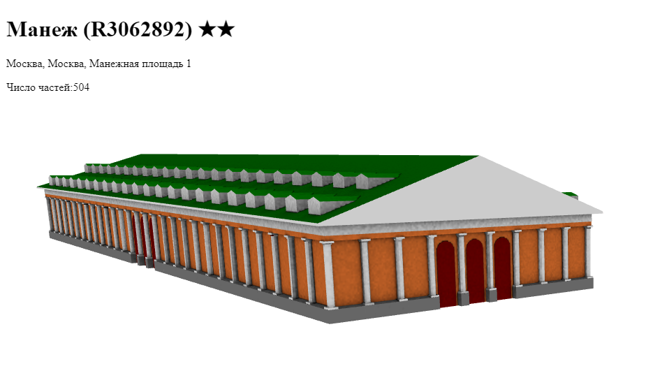
Доводить его до 6 тысяч элементов наверно смысла нет, хотя возможность такая есть)
У меня в рендере выглядит нормально, а F4 что-то подколбашивает.
UPD: F4 обновилось, и выглядит просто отлично:
Говорят что F4 нуждается в теге roof:orientation. Мне не жалко, но зачем оно ей, я не понимаю))
P.S. Принимаю заказы на осм-модели зданий в Москве и Петербурге, желательно в стиле ампир :)
On November 13, 2023, Miami-Dade County’s transit agency, Miami-Dade Transit, implemented significant changes to its bus network - designated the “Better Bus Network.” These updates aimed to enhance coverage for neighborhoods and business districts that primarily serve lower-income residents. As a result, many routes and stops were altered, relocated, or removed.
To the best of my knowledge, much of Miami’s transit data on OSM was originally contributed by user drynwk around 2021. Most of their contributions have remained untouched for nearly three years, despite the major changes from the Better Bus Network almost a year ago.
Miami-Dade Transit has provided updated transit information to platforms like Google Maps, Apple Maps, and likely other GIS services. I believe it’s essential that OSM volunteers also have access to this data. To that end, I’ll be making an effort to obtain the relevant information from Miami-Dade Transit and share it with the OSM community here in Miami.
In addition, I plan to update the bus route relations on OSM to reflect the new route names, ideally matching the official names used by Miami-Dade Transit across their buses, maps, and app. I’ll also be reaching out to request the correct route names for accuracy.
Hallo Open StreetMap ist wirklich ein sehr cooles Projekt, Respekt und Dank an alle Menschen die das durch ihre hervorragenden Leistungen möglich machen. ich habe jetzt länger gesucht ob man die Weltkarte nicht auf Englisch umstellen kann , ich bin leider bei längerer Suche nicht darauf gestossen , wo ist denn der Umschaltknopf auf englische Sprache , ich kann leider nicht Russisch Arabisch oder Chinesisch usw lesen… des weiteren benutze ich viele Linux Software mit OSM Karten leider nicht mehr auf Englisch das ganze …kann mir jemand weiterhelfen?
การดูมุมมองจากที่สูง
ธรรมชาติที่แสนหาดูอยากจากมุมองจากที่สูง

Hi all!
I’m Freya and been a contributor since April 2024. I’ve since then noticed there is a lack of diversity that covers different groups of people to make them feel welcome or drive questions as a team rather than as spread out individuals here and there
We will not be doing work that Local Chapters and Communities Working Group is already doing, instead we will be working towards highlighting ways to be inclusive, organizing projects to increase accessibility in specific areas, or just hosting a friendly place for people to chat in!
To start with I’ve setup a wiki page containing what exactly the goal is and how we will work, and my plan is to develop this initiative as time goes on and more people get interested
We also use the Contributor Covenant v2.1 as our Code of Conduct
No projects setup yet but in the plans to organize an event soon! :pray:
Here’s a few resources I’ve setup for now
امروز فرارت شلوغ بود ترافیک زیاد و چندتا ماشینم خراب شده بودند
امروز فرارت شلوغ بود ترافیک زیاد و چندتا ماشینم خراب شده بودند

Visualization of changesets, dis/likes, more hotkeys and viewing old versions of map objects
🖼 Visualization of changesets
Previously, you could only view changes in tags and only minor changesets. Now you can see objects that have been changed, and pagination is removed whenever possible:
- Directly on osm.org
- 😎 OSM API only →
- you can watch even a few seconds after loading
- independence from Overpass API and OSMCha
Be sure to explore the interface 😉 Many elements can be clicked (even twice :)
⚠️ Limitations:
- I call it QuickLook for a reason, because not all changes can be displayed
- large relations must be loaded manually and via the Overpass API
- sometimes objects may not be displayed - you may need to reload the tab
- in case of problems, you can disable the visualization of changesets in the settings
👍 👎 (Dis)likes
OSMCha has long praised the mapper for useful edits. Or warn about vandalism. But now you can do it directly without leaving osm.org.
⌨️ Hotkeys
But what if you can’t do without OSMCha?
Press O! Or shift + O to open Achavi
Last update added all two keyboard shortcuts. I’m fixing this sadness:
D— open Map data layerN— show notesG— GPX tracksS— ESRI satellite imagery (Firefox only)-
shift + S— ESRI Beta E— open your default editor-
shift + E— open the remaining editor -
,/.— move between user edits or object versions 1— Open the first version of the map item-
H— open the item’s history or recent changesets 8,9— for JOSM fans, move to the previous page/next position on the mapZ— navigate to the current object (as in iD)0— moves the map to a global zoom
🏺 Objects history
On the map item history page, you can now load the old version of the map item.
Install: https://github.com/deevroman/better-osm-org
P.S. Oh yes, I forgot
Posted by UNGSC-DTLM-Ale_Zena on 26 September 2024 in English.
Working mainly in Africa it’s not rare to come across to crowdsourced powered mapped areas. I still repair, from time to time, the disaster done in 2022 in Mogadishu
Today, near Bor https://www.openstreetmap.org/#map=17/6.178444/31.578194 , another masterpiece: a lot of triangular (one 2600 sqm trapezoidal) buildings, and 3 tourism=camp_site
Who does need this rubbish? How good the validator to the related HOT task worked?
Alessandro
Posted by Joseph Munyenze Kathukya on 26 September 2024 in English.

Hello fellow mappers! 👋
As an avid contributor to OpenStreetMap, I’ve found that having quick access to helpful resources can make the mapping process smoother and more enjoyable. Whether you’re mapping disaster-stricken areas 🌪️ or filling in the gaps for unmapped communities 🏞️, these resources will help you along the way.
Here are some key tools and resources that have been invaluable for me during my mapping journey:
🔑 OSM Resources for Mappers
-
OpenStreetMap Wiki
A comprehensive resource on all things OSM, including documentation, tagging guidelines, and community projects.
➡️ OSM Wiki -
LearnOSM
If you’re new to mapping, this guide is an excellent starting point. It covers the basics and also includes more advanced tutorials for improving your mapping skills.
➡️ Learn OSM -
HOT Tasking Manager
If you want to contribute to humanitarian mapping projects, the Humanitarian OpenStreetMap Team (HOT) Tasking Manager helps you find tasks related to disaster response and global development.
➡️ HOT Tasking Manager -
iD Editor
A simple web-based editor that’s perfect for beginners. You can edit maps directly in your browser without the need for external software.
➡️ iD Editor - JOSM (Java OpenStreetMap Editor)
A more advanced desktop editor for OSM, offering powerful features for experienced mappers who want to work on larger projects.
➡️ JOSM Editor ➡️ JOSM Download -
Mapillary
This tool lets you access street-level imagery for places where map data might be missing or outdated. It integrates well with OSM for adding detail to map features.
➡️ Mapillary -
Overpass Turbo
A query tool for filtering specific OSM data, helping you search for, and visualize, map features based on tags or location.
➡️ Overpass Turbo - OSMCha
A tool for reviewing changesets and helping to ensure map quality. It’s great for monitoring edits and improving the accuracy of mapping data.
➡️ OSMCha
🧑🤝🧑 Join the Community
There are many ways to get involved with other mappers and contribute to the global effort of making OSM the most comprehensive map resource.
-
OSM Community Forum
Discuss mapping issues, seek advice, or share your projects with the OSM community.
➡️ OSM Forum -
OSM Mailing Lists
Stay updated on the latest developments in OSM and contribute to discussions with the community via mailing lists.
➡️ OSM Mailing Lists
These resources have been instrumental in helping me contribute more effectively to areas in need of better map coverage. Whether you’re a beginner or a seasoned mapper, I hope you find them as useful as I have.
Let’s continue mapping for a better future! 🌍✍️
Feel free to drop your favorite resources in the comments, or share any tips you have for using these tools. Happy mapping!
writers profesional

I really wanted to participate in the State of the Map 2024 in Kenya to broaden my horizons, understand what is happening under other skies and exchange with members of other communities to draw from their experience: How they are organized and how they stay dynamic. My illusions found a dazzling light, from the moment the scholarship team accepted my application. I was so happy like my wedding day. 😃
The 3 days were each particularly better, the different subjects selected were breathtaking
 With many people we knew each other by face only through video conferences. I had the privilege of meeting exceptional people full of good qualities. The smiles, the mutual respect, the solidarity, the brotherly love, the sincerity, the courtesy among the participants was exceptional. I really appreciated the social cohesion of the Community it is the result of community engagement which has already fostered this feeling of belonging and solidarity. Fortunately, this community engagement has already created a solid social fabric, strengthened interpersonal relationships and promoted collective well-being. Well done to anyone who worked on online community engagement.
During and after these 3 days of joy and discovery.
The second day, I had the privilege of serving as a volunteer to take care of the Micro-player in the room MAASAI MARA. I also found the opportunity to develop skills, self-confidence and leadership through volunteering.

When the Big manger, the community Project Lead Geoffrey Kateregga did a briefing with all the volunteers to reassure themselves of the same understanding of the principles so that everything goes well in the different conference rooms. At the end of this briefing, I realized that the success of a major conference requires the involvement of everyone.
I encourage volunteering on days like this, because it allows you to feel effective by making yourself useful while developing self-esteem.

Many thanks Zachariah Muindi And Laura Mugeha fo having thought to this: A Replicable Model for OpenStreetMap Training Programs in High Schools This approach is power for a sustainable community.

Séverin Ménard and Michael Montani, thank you also for this workshop on data validation: Hands-on data validation on OSM: best practices and tools. Personally I used OSMOSE for quality control and for online validation workshops, I was reinforced in technique and skills by your presentation.

The particular situation of the DRC required a lot of effort, Thank you Claire Halleux for developing this theme: Improving data homogeneity across a country, in the context of the DRC.
I think this model is ok, it can work in the DRC, this approach here: A Replicable Model for OpenStreetMap Training Programs in High Schools.

The open questions session OSMF Board AMA, allowed understanding of the close collaboration between the OSM foundation and the board of directors. I followed with great attention the question about the local chapters of the OSM foundation. If I understood correctly, for a local community to be a local chapter, there is conditions to be met 
Another session I was looking forward to attending on HOTOSM Voting Member Meet up. In this meeting, the President of the Voting Member spoke about VM’s involvement in HOTOSM activities and recalled the role of VM. We had the joy of meeting physically to discuss HOTOSM Living Strategy. To this I say a big thank you to all the VMs who participated in the session, in the debate, the location question was the hot point.
Somewhere I heard this term The stylish HOT Voting Members Chair apply to me, I don’t know how this came about, but hey, it doesn’t break the tiles.🤩

I say thank you to the organizing team of this global event in Africa and to all the partners, as well as everyone who, directly or indirectly, made the success of this conference possible.

Well, if it were up to me, I’d like to be regular at State of the Map.
Posted by kowaw on 26 September 2024 in Chinese (China) (中文(中国大陆)).
Last updated on 27 September 2024.
情况一:
在建的的道路;如下图所示,请使用highway=construction。

情况二:
因改建工程改建的路段(立交桥,道路扩建工程);如下图所示,请使用highway=construction;
其余因改造封闭的路段在下认为使用access=no为佳。

情况三:
高速公路、普通公路在修建时所作出的预留车道;如下图所示,请使用access=no。


情况四:
下水道/管道改造等路段请使用highway=construction;其余原因封闭的路段皆使用access=no。
情况五:
规划路段请使用highway=proposed。
以上为在下的个人观点,欢迎各位发表意见。