Balkans Regional Atlas
Jump to navigation
Jump to search
The Balkans Regional Atlas was published by the US Central Intelligence Agency in 1997. It has political, ethnic, natural resources, energy, economic use, and land use maps for Bosnia and Herzegovina, Croatia, Serbia and Montenegro, and the Republic of Macedonia.
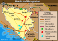
Bosnia and Herzegovina
[edit]-
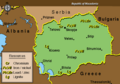
 Political
 -
 Ethnic
 -
 Mineral & resources
 -
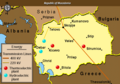
 Energy
 -
 Economic activity
 -
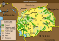
 Land use


Croatia
[edit]-
 Political
 -
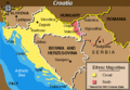 Ethnic
 -
 Mineral & resources
 -
 Energy
 -
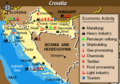 Economic activity
 -
 Land use


Serbia and Montenegro
[edit]-
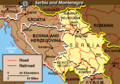 Political
 -
 Ethnic
 -
 Mineral & resources
 -
 Energy
 -
 Economic activity
 -
 Land use


Republic of Macedonia
[edit]-
 Political
 -
 Ethnic
 -
 Mineral & resources
 -
 Energy
 -
 Economic activity
 -
 Land use


