Category:18th-century maps of the United States
Jump to navigation
Jump to search
Countries of North America: Antigua and Barbuda · The Bahamas · Barbados · Belize · Canada · Costa Rica · Cuba · Dominica · Guatemala · Haiti · Honduras · Jamaica · Mexico · Nicaragua · Panama · Saint Kitts and Nevis · Saint Vincent and the Grenadines · Trinidad and Tobago‡ · United States of America‡
Other territories: Bermuda · Greenland · Guadeloupe · Martinique · Puerto Rico
‡: partly located in North America
Other territories: Bermuda · Greenland · Guadeloupe · Martinique · Puerto Rico
‡: partly located in North America
Subcategories
This category has the following 59 subcategories, out of 59 total.
#
A
- 18th-century maps of Arizona (10 F)
C
D
F
G
H
- 18th-century maps of Hawaii (4 F)
I
K
- 18th-century maps of Kansas (1 F)
L
M
N
- 18th-century maps of Nevada (2 F)
O
- 18th-century maps of Oregon (2 F)
P
R
S
T
- 18th-century maps of Texas (12 F)
U
- 18th-century maps of Utah (6 F)
V
W
Media in category "18th-century maps of the United States"
The following 13 files are in this category, out of 13 total.
-
 Carte generale des treize Etats Unis, de lAmerique septentrionale (4232068622).jpg 2,000 × 1,661; 2.91 MB
-

-

-
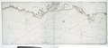
 Carte von dem Hafen und der Stadt Boston (2675343222).jpg 2,000 × 1,724; 3.29 MB
-
 Henderson grant map.jpg 2,700 × 1,800; 1.02 MB
-
 Henderson Kentucky Grant Map.pdf 1,650 × 2,550; 1.74 MB
-
 Henderson Powell Valley Grant.jpg 1,596 × 1,592; 838 KB
-

-
 A new and general map of the southern dominions belonging to the United States of America (NYPL b20643864-5452687).tiff 10,328 × 7,760, 2 pages; 229.61 MB
-
 Ohio Country de.png 1,217 × 920; 1.42 MB
-
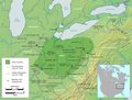 Ohio Country en.png 1,217 × 920; 1.41 MB
-
-
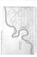
 Transactions of the American Philosophical Society (1771) (14780862225).jpg 1,434 × 2,042; 402 KB
.jpg)
.jpg)


_(14780862225).jpg)