Category:2012 Pacific Northwest snowstorm
Jump to navigation
Jump to search
 | |||||
| Upload media | |||||
| Instance of | |||||
|---|---|---|---|---|---|
| Location |
| ||||
| Point in time |
| ||||
| |||||
Media in category "2012 Pacific Northwest snowstorm"
The following 51 files are in this category, out of 51 total.
-
 AfghanIraqHighWater.JPG 1,200 × 1,600; 664 KB
-
 AfghanIraqHighWater2.JPG 1,600 × 1,200; 909 KB
-
 Arata Creek flows onto I-84 east of Portland (6733255599).jpg 1,600 × 1,200; 298 KB
-
 Clearing debris from clogged culvert (6771749449).jpg 1,024 × 768; 204 KB
-
 Clearing debris from under Highway 42 (6732645517).jpg 704 × 480; 60 KB
-
 Debris plugs culvert on OR 38 (6726269097).jpg 3,264 × 1,836; 988 KB
-
 FloodGates.JPG 1,600 × 1,200; 480 KB
-
 FloodGates2.JPG 1,600 × 1,200; 476 KB
-
 Flooding14thandAStreet.JPG 1,600 × 1,200; 679 KB
-
 Flooding18th andChemeketa.JPG 1,600 × 1,200; 753 KB
-
 FloodingatState23rdJan192012.JPG 1,600 × 1,200; 672 KB
-
 FloodingBehindVetsBldg.JPG 1,600 × 1,200; 623 KB
-
 FloodingDoughboy.JPG 1,200 × 1,600; 585 KB
-
 FloodingLookingWestTowardSummerStAcrossMillCreek.JPG 1,600 × 1,200; 553 KB
-
 FootbridgeMillCreekCourtStJan192012.JPG 1,600 × 1,200; 1.02 MB
-
 HighWater17thandChemeketa.JPG 1,600 × 1,200; 655 KB
-
 HighWater17thMillCreek.JPG 1,600 × 1,200; 762 KB
-
 HighWateratChemeketaMillCreek.JPG 1,600 × 1,200; 738 KB
-
 HighwateratCourtStBridgeJan192012.JPG 1,600 × 1,200; 639 KB
-
 HighWaterBehindSafeway.JPG 1,600 × 1,200; 786 KB
-
 HighWaterBehindStraubCenter.JPG 1,600 × 1,200; 705 KB
-
 HighWaterCenterand14th.JPG 1,600 × 1,200; 724 KB
-
 HighWaterChemeketaLookingNorth.JPG 1,600 × 1,200; 797 KB
-
 HighWaterLookingtowardSafeway.JPG 1,600 × 1,200; 729 KB
-
 HighWaterMillCreekBehindOlinger.JPG 1,600 × 1,200; 705 KB
-
 HighWaterNearUnionStreet.JPG 1,600 × 1,200; 630 KB
-
 InstallingFloodGates.JPG 1,600 × 1,200; 619 KB
-
 InstallingFloodGates2.JPG 1,600 × 1,200; 606 KB
-
 LookingNorthFlooding14thStreet.JPG 1,200 × 1,600; 722 KB
-
 Mapleton, OR on Jan. 19, 2012 (6752204295) (cropped).jpg 1,381 × 1,200; 192 KB
-
 Mapleton, OR on Jan. 19, 2012 (6752204295).jpg 1,600 × 1,200; 282 KB
-
 MillCreekFountainHighWater.JPG 1,600 × 1,200; 849 KB
-
 MillCreekHighWater.JPG 1,600 × 1,200; 848 KB
-
 MillCreekHighWaterJan19.JPG 1,600 × 1,200; 858 KB
-
 MillCreekOverFloodStage.JPG 1,600 × 1,200; 905 KB
-
 MillCreekSalemJan19.JPG 1,600 × 1,200; 852 KB
-
 MillCreekSummerStreetBridgeJan19.JPG 1,600 × 1,200; 856 KB
-
 NorthSalemHSFootballFieldFlooded.JPG 1,600 × 1,200; 591 KB
-
 OR Route 38 erosion, Jan. 2012 storm.jpg 2,816 × 2,112; 1.15 MB
-
 Oregon Highway 36 in Mapleton (6752204151).jpg 1,600 × 1,200; 204 KB
-
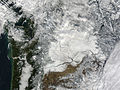 Pacific NW after storm, satellite view.jpg 3,200 × 2,400; 3.28 MB
-
 SandbaggingAlongStateStreetMillCreek.JPG 1,600 × 1,200; 562 KB
-
 SandbagstoProtectAgBldg.JPG 1,600 × 1,200; 695 KB
-
 Sandy River Bridge debris (6767584311).jpg 400 × 402; 51 KB
-
 Slide mitigation Oregon Highway 138 (6771841543).jpg 512 × 384; 36 KB
-
 Slumping highway (6771794469).jpg 640 × 480; 46 KB
-
 StateStreetFloodingJan192012.JPG 1,200 × 1,600; 536 KB
-
 U.S. 101 at milepost 333 near Gold Beach (6771794541).jpg 640 × 480; 62 KB
-
 Under this lake is a highway (6771749331).jpg 640 × 480; 69 KB
-
 VFWMemorialHighWaterJan19.JPG 1,600 × 1,200; 708 KB
-
 WheretheyDumpedtheColumns1935.JPG 1,600 × 1,200; 560 KB


.jpg)
.jpg)


_(cropped).jpg)
.jpg)


.jpg)


.jpg)
.jpg)
.jpg)

.jpg)
.jpg)


.jpg)
.jpg)