Category:Castle Bolton with East and West Bolton
Jump to navigation
Jump to search
civil parish in Richmondshire, North Yorkshire, England .jpg) | |||||
| Upload media | |||||
| Instance of | |||||
|---|---|---|---|---|---|
| Standort | Richmondshire, North Yorkshire, Yorkshire and the Humber, England | ||||
 | |||||
English: Castle Bolton with East and West Bolton is a civil parish in the Richmondshire district, in the county of North Yorkshire, England.
Media in category "Castle Bolton with East and West Bolton"
The following 200 files are in this category, out of 259 total.
(previous page) (next page)-
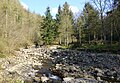
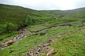
 A tributary of Apedale Beck - geograph.org.uk - 4300459.jpg 5,400 × 3,600; 2.67 MB
-
 Above Carperby - geograph.org.uk - 2358885.jpg 3,264 × 2,448; 2.67 MB
-
 Access to Bolton West Park - geograph.org.uk - 4301887.jpg 5,400 × 3,600; 6.87 MB
-
 Across the bog - geograph.org.uk - 2910830.jpg 1,600 × 1,200; 447 KB
-
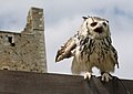 An owl at Bolton Castle - geograph.org.uk - 4555067.jpg 1,024 × 728; 112 KB
-
 Apedale - geograph.org.uk - 1617039.jpg 640 × 480; 218 KB
-
 Apedale - geograph.org.uk - 3490577.jpg 1,600 × 1,200; 600 KB
-
 Apedale - geograph.org.uk - 4734104.jpg 6,000 × 4,000; 4.58 MB
-
 Apedale - outcrop - geograph.org.uk - 1617042.jpg 480 × 640; 174 KB
-
 Apedale Beck - geograph.org.uk - 4250832.jpg 480 × 640; 79 KB
-
 Apedale Beck - geograph.org.uk - 4300481.jpg 5,400 × 3,600; 3.73 MB
-
 Apedale Beck - geograph.org.uk - 4453387.jpg 640 × 360; 104 KB
-
 Apedale Beck - geograph.org.uk - 4734055.jpg 6,000 × 4,000; 4 MB
-
 Apedale beck - geograph.org.uk - 4734069.jpg 6,000 × 4,000; 4.32 MB
-
 Apedale Beck - geograph.org.uk - 4735503.jpg 6,000 × 4,000; 5.87 MB
-
 Apedale Beck - geograph.org.uk - 5533732.jpg 640 × 427; 131 KB
-
 Apedale Beck - geograph.org.uk - 6123284.jpg 1,600 × 1,112; 516 KB
-
 Apedale Beck, Redmire - geograph.org.uk - 2135401.jpg 640 × 481; 94 KB
-
 Apedale Head - geograph.org.uk - 1617037.jpg 640 × 480; 210 KB
-
 Apedale Mine - geograph.org.uk - 2911058.jpg 1,600 × 1,200; 443 KB
-
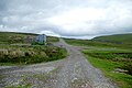
 Apedale Road (view east) - geograph.org.uk - 1814277.jpg 2,048 × 1,536; 1.56 MB
-
 Apedale Road - geograph.org.uk - 5603202.jpg 5,184 × 3,456; 5.86 MB
-
 Apedale Road - geograph.org.uk - 6174741.jpg 1,024 × 768; 138 KB
-
 Apedale road - geograph.org.uk - 6538530.jpg 5,472 × 3,648; 6.98 MB
-
 Apedale road junction - geograph.org.uk - 6538545.jpg 5,472 × 3,648; 5.94 MB
-
 Approaching Dent's Houses - geograph.org.uk - 4250889.jpg 640 × 480; 75 KB
-
 Beginning to flow downhill - geograph.org.uk - 2910838.jpg 1,600 × 1,200; 466 KB
-
 Bell Beck Wood - geograph.org.uk - 4735509.jpg 6,000 × 4,000; 5.9 MB
-
 Bell Pits on Bobscar Rake - geograph.org.uk - 2910990.jpg 1,600 × 1,200; 333 KB
-

-
 Benchmark on Scallow Bank Lane railway bridge - geograph.org.uk - 2597989.jpg 683 × 1,024; 270 KB
-
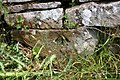
 Benchmark on St Oswald's Church - geograph.org.uk - 2516456.jpg 683 × 1,024; 314 KB
-
 Benchmark on stone in wall of Scallow Bank Lane - geograph.org.uk - 2598058.jpg 1,024 × 683; 301 KB
-
 Benchmark on the garage of Jacksons Cottage - geograph.org.uk - 2516505.jpg 683 × 1,024; 261 KB
-

-
 Blackhill Park - geograph.org.uk - 4453379.jpg 640 × 359; 97 KB
-
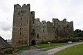
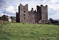
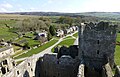
 Bolton Castle (detail) - geograph.org.uk - 4554830.jpg 697 × 1,024; 301 KB
-
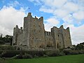
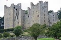
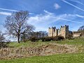 Bolton Castle - geograph.org.uk - 4411139.jpg 640 × 480; 127 KB
-
 Bolton Castle - geograph.org.uk - 5627797.jpg 4,000 × 3,000; 2.2 MB
-
 Bolton Castle - geograph.org.uk - 5862571.jpg 1,024 × 683; 199 KB
-
 Bolton Castle - geograph.org.uk - 6066544.jpg 1,600 × 802; 480 KB
-
 Bolton Castle - geograph.org.uk - 6111715.jpg 1,024 × 768; 160 KB
-
 Bolton Castle - geograph.org.uk - 6122717.jpg 1,600 × 1,144; 342 KB
-
 Bolton Castle - geograph.org.uk - 6502189.jpg 1,024 × 576; 107 KB
-
 Bolton Castle - geograph.org.uk - 6506014.jpg 768 × 1,024; 201 KB
-
 Bolton Castle - geograph.org.uk - 6507543.jpg 1,024 × 768; 181 KB
-
 Bolton Castle at Castle Bolton - geograph.org.uk - 4623520.jpg 1,024 × 633; 517 KB
-
 Bolton Castle at Castle Bolton, Wensleydale - geograph.org.uk - 4554915.jpg 683 × 1,024; 318 KB
-
 Bolton Castle at Castle Bolton, Wensleydale - geograph.org.uk - 4554922.jpg 1,024 × 683; 262 KB
-
 Bolton Castle from Castle Gardens - geograph.org.uk - 6502194.jpg 1,024 × 576; 91 KB
-
 Bolton Castle from the East - geograph.org.uk - 5533744.jpg 640 × 427; 56 KB
-
 Bolton Castle from the South - geograph.org.uk - 4853571.jpg 1,600 × 1,067; 589 KB
-
 Bolton Castle from the Village - geograph.org.uk - 4853553.jpg 1,600 × 1,067; 466 KB
-
 Bolton Castle from the west - geograph.org.uk - 5794818.jpg 4,588 × 3,428; 4.85 MB
-
 Bolton Castle overlooking Wensleydale - geograph.org.uk - 4852934.jpg 1,600 × 1,067; 445 KB
-
 Bolton Castle, aerial (2) - geograph.org.uk - 5897608.jpg 800 × 533; 107 KB
-
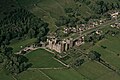
 Bolton Castle, aerial 2018 (1) - geograph.org.uk - 5897602.jpg 800 × 533; 118 KB
-
 Bolton Gill - geograph.org.uk - 3843815.jpg 4,320 × 3,240; 4.77 MB
-
 Bolton West Park - geograph.org.uk - 6174705.jpg 1,024 × 768; 163 KB
-
 Boundary Stone on Mere Gill Head - geograph.org.uk - 4677380.jpg 4,000 × 3,000; 3.81 MB
-
 Boundary stone, Height of Greets (2) - geograph.org.uk - 5412924.jpg 480 × 640; 175 KB
-
 Boundary stone, Height of Greets - geograph.org.uk - 5412923.jpg 480 × 640; 158 KB
-
 Bridge over Apedale Beck - geograph.org.uk - 5533647.jpg 640 × 427; 105 KB
-
 Bridge over Beldon Beck - geograph.org.uk - 2850685.jpg 4,000 × 3,000; 2.96 MB
-
 Bridging the gap^ - geograph.org.uk - 946381.jpg 480 × 640; 112 KB
-
 Bridleway crossing crest of ridge at Black Hill - geograph.org.uk - 6066674.jpg 1,600 × 1,090; 618 KB
-
 Bridleway heading for Apedale Head - geograph.org.uk - 5603210.jpg 5,184 × 3,456; 7.55 MB
-
 Bridleway on Black Hill - geograph.org.uk - 4733925.jpg 6,000 × 4,000; 3.85 MB
-
 Bridleway to Greets Hill - geograph.org.uk - 6538558.jpg 5,472 × 3,648; 5.61 MB
-
 Bull Park Plantation - geograph.org.uk - 6066648.jpg 1,600 × 938; 537 KB
-
 Bull Park Plantation and Blackhill Park - geograph.org.uk - 4300793.jpg 5,400 × 3,600; 2.67 MB
-
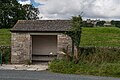 Bus Shelter on the Carperby Road - geograph.org.uk - 4156061.jpg 640 × 425; 308 KB
-
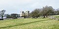
 Castle Bolton - geograph.org.uk - 4853559.jpg 1,600 × 1,067; 538 KB
-
 Castle Bolton - geograph.org.uk - 5490042.jpg 1,024 × 661; 261 KB
-
 Castle Bolton - geograph.org.uk - 5490046.jpg 1,024 × 689; 248 KB
-
 Castle Bolton and church - geograph.org.uk - 3511522.jpg 1,024 × 680; 173 KB
-
 Castle Bolton viewed from the South - geograph.org.uk - 1956533.jpg 800 × 533; 119 KB
-
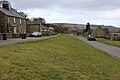
 Castle Bolton village - geograph.org.uk - 6122702.jpg 1,600 × 1,025; 323 KB
-
 Castle Bolton village sign - geograph.org.uk - 5627780.jpg 3,000 × 4,000; 3.36 MB
-
 Castle Bolton, aerial 2016 - geograph.org.uk - 5089754.jpg 498 × 384; 48 KB
-
 Castle Bolton, aerial 2016 - geograph.org.uk - 5089881.jpg 640 × 427; 70 KB
-
 Castle Bolton, aerial 2018 - geograph.org.uk - 5897549.jpg 800 × 533; 116 KB
-
 Castle View cottages, Castle Bolton - geograph.org.uk - 5533736.jpg 640 × 427; 53 KB
-
 Circular grouse butt beside estate road - geograph.org.uk - 5670048.jpg 1,500 × 1,125; 1.56 MB
-
 Collier Gate - geograph.org.uk - 239090.jpg 640 × 480; 94 KB
-
 Confluence of Apedale Beck - geograph.org.uk - 6538515.jpg 5,472 × 3,648; 7.39 MB
-
 Cottage on East Lane, Castle Bolton - geograph.org.uk - 5535393.jpg 640 × 427; 93 KB
-
 Cottages, Castle Bolton - geograph.org.uk - 5526250.jpg 3,888 × 2,592; 5.14 MB
-
 Cottages, Castle Bolton - geograph.org.uk - 5535396.jpg 640 × 427; 66 KB
-
 Course of Old Railway - geograph.org.uk - 4411145.jpg 640 × 480; 144 KB
-
 Crossing Galeclose Beck - geograph.org.uk - 4412312.jpg 640 × 480; 150 KB
-
 Cut benchmark, Dent's Houses - geograph.org.uk - 5379770.jpg 640 × 480; 151 KB
-
 De Havilland Mosquito TA525 - geograph.org.uk - 4686758.jpg 4,320 × 2,880; 4.96 MB
-
 Dent's Houses - geograph.org.uk - 1617045.jpg 640 × 480; 168 KB
-
 Dent's Houses - geograph.org.uk - 5379758.jpg 800 × 600; 184 KB
-
 Dent's Houses - geograph.org.uk - 6174745.jpg 1,024 × 768; 186 KB
-
 Derelict field barn at Scrogs Lane - geograph.org.uk - 6356465.jpg 800 × 533; 177 KB
-
 Disturbed Ground - geograph.org.uk - 4250860.jpg 640 × 480; 92 KB
-
 Disturbed ground on Height of Greets - geograph.org.uk - 2528519.jpg 1,500 × 927; 1.13 MB
-
 Disused lead level near Jingle Pot Gill - geograph.org.uk - 5887124.jpg 1,024 × 770; 269 KB
-
 Disused Leat, East Bolton Moor - geograph.org.uk - 4453376.jpg 640 × 480; 147 KB
-

-
 Drainage channel flowing into Apedale - geograph.org.uk - 4734045.jpg 6,000 × 4,000; 4.69 MB
-
 Drainage ditch above Castle Bolton - geograph.org.uk - 4300785.jpg 5,400 × 3,600; 2.67 MB
-
 Dressing Floor ^ Bouse Teams - geograph.org.uk - 2911070.jpg 1,600 × 1,200; 330 KB
-
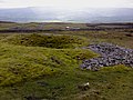
 East Bolton Moor - geograph.org.uk - 1814300.jpg 2,048 × 1,536; 1.54 MB
-
 East Bolton Moor.jpg 4,608 × 3,456; 9.66 MB
-
 East Lane towards Castle Bolton - geograph.org.uk - 5535391.jpg 640 × 427; 117 KB
-
 Ellerlands from the spoil heap - geograph.org.uk - 6174761.jpg 1,024 × 768; 181 KB
-
 Evening light on Bolton Castle - geograph.org.uk - 6505654.jpg 1,799 × 1,199; 426 KB
-
 Farm buildings and a tiny beck by Intake Plantation - geograph.org.uk - 4301870.jpg 5,400 × 3,600; 2.58 MB
-
 Farm buildings at Low Bolton - geograph.org.uk - 3843820.jpg 4,320 × 3,240; 4.83 MB
-
 Farm buildings at Low Bolton - geograph.org.uk - 4300445.jpg 5,400 × 3,600; 2.4 MB
-
 Farm buildings, Castle Bolton - geograph.org.uk - 5535389.jpg 640 × 427; 60 KB
-
 Farmland in Wensleydale - geograph.org.uk - 4300731.jpg 5,400 × 3,600; 1.81 MB
-
 Featureless Moor between High Carl and Gibbon Hill - geograph.org.uk - 5603222.jpg 5,184 × 3,456; 7.03 MB
-
 Feetham and River Swale, aerial 2018 - geograph.org.uk - 5906211.jpg 800 × 533; 100 KB
-
 Fence between West Bolton Moor and Whitaside Moor - geograph.org.uk - 5555970.jpg 5,184 × 3,456; 6.09 MB
-
 Fence Line between High Carl and Gibbon Hill - geograph.org.uk - 5603217.jpg 5,184 × 3,456; 7.07 MB
-
 Fence Line East of Gibbon Hill (2) - geograph.org.uk - 5603408.jpg 5,184 × 3,456; 5.84 MB
-
 Fenced enclosure on Bolton West Park - geograph.org.uk - 4301886.jpg 5,400 × 3,600; 7.63 MB
-
 Fenceline leading up to High Carl - geograph.org.uk - 1856442.jpg 3,765 × 2,503; 4.01 MB
-
 Fields below Ellerlands Edge - geograph.org.uk - 4301676.jpg 5,400 × 3,600; 2.64 MB
-
 Fields Below Ellerlands Edge - geograph.org.uk - 585091.jpg 640 × 427; 49 KB
-
 Fields to Bolton Castle - geograph.org.uk - 1409650.jpg 640 × 480; 67 KB
-
 Footbridge and Ford West Bolton - geograph.org.uk - 4156046.jpg 640 × 425; 460 KB
-
 Footbridge over Apedale Beck - geograph.org.uk - 1956561.jpg 800 × 533; 157 KB
-
 Footbridge over Beldon Beck - geograph.org.uk - 4302771.jpg 5,400 × 3,600; 3.07 MB
-
 Footbridge over Beldon Beck Low Thoresby - geograph.org.uk - 4156059.jpg 640 × 425; 452 KB
-
 Footpath between Castle Bolton and Redmire - geograph.org.uk - 4853580.jpg 1,600 × 1,067; 455 KB
-
 Footpath sign beside benchmarked gatepost - geograph.org.uk - 2598115.jpg 683 × 1,024; 228 KB
-
 Footpath to Castle Bolton - geograph.org.uk - 1956554.jpg 800 × 533; 125 KB
-
 Ford on the track by Smithy Gill - geograph.org.uk - 6174737.jpg 1,024 × 768; 200 KB
-
 Gate on Apedale Road - geograph.org.uk - 5412912.jpg 720 × 540; 117 KB
-
 Gate on footpath at Bolton West Park - geograph.org.uk - 4156047.jpg 640 × 425; 394 KB
-
 Gate on the Height of Greets - geograph.org.uk - 5603418.jpg 5,184 × 3,456; 6.5 MB
-
 Gate to open land above Castle Bolton - geograph.org.uk - 4300773.jpg 5,400 × 3,600; 2.16 MB
-
 Gateway across track to Bolton Castle - geograph.org.uk - 3538529.jpg 1,024 × 683; 193 KB
-
 Gibbon Hill - geograph.org.uk - 4500193.jpg 1,600 × 1,200; 466 KB
-
 Gloster Javelin F.A.W.Mk.5 XA662 - geograph.org.uk - 4688507.jpg 4,320 × 2,880; 5.38 MB
-
 Gloster Javelin F.A.W.Mk.5 XA662 - geograph.org.uk - 4688536.jpg 4,320 × 2,880; 5.05 MB
-
 Grassed over mine spoil at Bolton Park Lead Mine - geograph.org.uk - 6066660.jpg 1,600 × 1,019; 531 KB
-
 Grassy moorland on Black Hill - geograph.org.uk - 4733936.jpg 6,000 × 4,000; 3.72 MB
-
 Greets Hill - geograph.org.uk - 3490585.jpg 1,600 × 1,200; 499 KB
-
 Greets Quarry - geograph.org.uk - 5412917.jpg 640 × 480; 99 KB
-
 Grinton Cross - geograph.org.uk - 4677367.jpg 3,000 × 4,000; 4.27 MB
-
 Grouse Butt, Greets Hill - geograph.org.uk - 4250870.jpg 640 × 480; 85 KB
-
 Grouse butts on Woodale Moor - geograph.org.uk - 6174715.jpg 1,024 × 768; 217 KB
-
 Grouse moor - geograph.org.uk - 6123330.jpg 1,600 × 1,067; 256 KB
-
 Height of Greets - geograph.org.uk - 5603412.jpg 5,184 × 3,456; 6.67 MB
-
 Hiding in the Thistles - geograph.org.uk - 946408.jpg 640 × 480; 134 KB
-
 Hillside above Apedale Beck - geograph.org.uk - 4734131.jpg 6,000 × 4,000; 4.27 MB
-
 Ice alongside estate road - geograph.org.uk - 5669137.jpg 1,500 × 1,125; 1.5 MB
-
 Indian Eagle Owl at Bolton Castle's falconry display - geograph.org.uk - 4993253.jpg 3,000 × 3,000; 1.92 MB
-
 Intake Plantation - geograph.org.uk - 4301872.jpg 5,400 × 3,600; 3.34 MB
-
 Jingle Pot - geograph.org.uk - 5379096.jpg 600 × 800; 204 KB
-
 Junction of fences on Gibbon Hill - geograph.org.uk - 1856428.jpg 3,872 × 2,592; 5.01 MB
-
 Large Cairn at Apedale Head - geograph.org.uk - 5603214.jpg 5,184 × 3,456; 7.72 MB
-
 Line of grouse butts on Black Hill - geograph.org.uk - 4734007.jpg 6,000 × 4,000; 4.2 MB
-
 Looking south west across Mere Gill - geograph.org.uk - 6122942.jpg 1,600 × 1,116; 196 KB
-
 Lunch spot - geograph.org.uk - 2910858.jpg 1,600 × 1,200; 465 KB
-
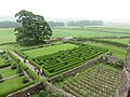 Maze and vineyard at Bolton Castle - geograph.org.uk - 4993249.jpg 4,000 × 3,000; 3.6 MB
-
 Millennium stone - geograph.org.uk - 3509479.jpg 680 × 1,024; 285 KB
-
 Mine Level near Apedale Beck - geograph.org.uk - 2911101.jpg 1,600 × 1,200; 323 KB
-
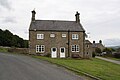
 Mine manager's house at Bolton Parks Lead Mine - geograph.org.uk - 6174764.jpg 1,024 × 768; 188 KB
-
 Mine workings in Apedale - geograph.org.uk - 2247635.jpg 2,000 × 1,500; 3.2 MB
-

-
 Miniature Cascade - geograph.org.uk - 946367.jpg 480 × 640; 116 KB
-

-
 Molehills below Bolton Castle - geograph.org.uk - 4300711.jpg 5,400 × 3,600; 2.68 MB
-
 Moorland above Wensleydale - geograph.org.uk - 4734035.jpg 6,000 × 4,000; 3.85 MB
-
 Moorland near Dent's Houses - geograph.org.uk - 4249520.jpg 640 × 480; 82 KB
-
 Moorland near Dent's Houses - geograph.org.uk - 4249523.jpg 640 × 480; 81 KB
-

-
 Moorland on north side of South Grain - geograph.org.uk - 6063018.jpg 1,600 × 918; 383 KB
-
 Moorland track to Dent's Houses - geograph.org.uk - 1814264.jpg 2,048 × 1,536; 1.51 MB
-
 Mosquito F.A.W.Mk5 TA525 - geograph.org.uk - 4686763.jpg 4,320 × 2,880; 5.16 MB
-
 Old Hush, Apedale Head Mine - geograph.org.uk - 2911122.jpg 1,600 × 1,200; 262 KB
-
 On Apedale Road - geograph.org.uk - 5603206.jpg 5,184 × 3,456; 6.13 MB
-
 On Gibbon Hill - geograph.org.uk - 4500244.jpg 1,600 × 1,200; 520 KB
-
 On High Carl - geograph.org.uk - 5603216.jpg 5,184 × 3,456; 7.32 MB
-
 On the Watershed between Swaledale and Wensleydale - geograph.org.uk - 5555956.jpg 5,184 × 3,456; 7.44 MB
-
 Pasture land west of Redmire - geograph.org.uk - 3843828.jpg 4,320 × 3,240; 4.58 MB
-
 Path by the wall above Beldon Beck - geograph.org.uk - 6111709.jpg 1,024 × 768; 204 KB
-
 Path near Black Hill - geograph.org.uk - 1814248.jpg 2,048 × 1,536; 1.82 MB
-
 Path near Castle Bolton - geograph.org.uk - 1814231.jpg 2,048 × 1,536; 2.3 MB
-
 Pickerstone Ridge - geograph.org.uk - 1752812.jpg 2,592 × 1,944; 1.24 MB
-
 Pond, Apedale Head - geograph.org.uk - 4453369.jpg 640 × 480; 107 KB
-
 Pool on Apedale Beck - geograph.org.uk - 4250847.jpg 640 × 480; 80 KB
-
 Private Wood Keep Out - geograph.org.uk - 6123155.jpg 1,600 × 1,022; 512 KB
-
 Public Bridleway, Black Hill - geograph.org.uk - 4453385.jpg 640 × 360; 90 KB
-
 Raised ridge on Bolton West Park - geograph.org.uk - 4301882.jpg 5,400 × 3,600; 3.33 MB
-
 Remains of Gloster Javelin - geograph.org.uk - 2105803.jpg 2,640 × 1,980; 850 KB
-
 Remnants of the old railway trackbed - geograph.org.uk - 1956540.jpg 800 × 533; 121 KB
-
 Road from Low Thoresby - geograph.org.uk - 2598800.jpg 683 × 1,024; 204 KB
-
 Ruined Barn - geograph.org.uk - 4411142.jpg 640 × 480; 168 KB
-
 Saint Oswald's church - geograph.org.uk - 4836888.jpg 800 × 600; 71 KB
-
 Scallow Bank Lane leads to Bolton Castle - geograph.org.uk - 5131631.jpg 2,180 × 1,156; 959 KB
-

-
 Shafts and Spoil - geograph.org.uk - 2911014.jpg 1,600 × 1,200; 272 KB


_-_geograph.org.uk_-_1814277.jpg)


_-_geograph.org.uk_-_4554830.jpg)


_-_geograph.org.uk_-_5897608.jpg)
_-_geograph.org.uk_-_5897602.jpg)


_-_geograph.org.uk_-_5412924.jpg)


_-_geograph.org.uk_-_5603408.jpg)


