Category:Clynderwen
Jump to navigation
Jump to search
Cymraeg: Pentref a chymuned yn Sir Benfro yw Clunderwen, weithiau Clynderwen yn Saesneg. Saif ar y briffordd A478 rhwng Arberth a phentref Crymych, ychydig i'r gogledd o Arberth.
English: Clynderwen is a rural village in Pembrokeshire, Wales. The village is known as a camping destination and is popular for self-catering holidays. It is also a community in Pembrokeshire, with its own community council of 10 members.
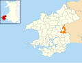
village and community in Pembrokeshire, Wales, UK   | |||||
| Upload media | |||||
| Instance of | |||||
|---|---|---|---|---|---|
| Location | Pembrokeshire, Wales | ||||
 | |||||
Subcategories
This category has the following 4 subcategories, out of 4 total.
Media in category "Clynderwen"
The following 150 files are in this category, out of 150 total.
-
 2010 Wales Pembrokeshire Community Clynderwen map.svg 512 × 393; 1,018 KB
-
 2024 Wales Pembrokeshire Community Clunderwen map.svg 512 × 393; 1.19 MB
-

-
 A478 leading north from Clunderwen - geograph.org.uk - 2056420.jpg 640 × 480; 57 KB
-

-
-
 Bethesda junction north of Clunderwen - geograph.org.uk - 4616998.jpg 800 × 517; 119 KB
-
 Boundary Stone - geograph.org.uk - 5255089.jpg 500 × 640; 158 KB
-
 Bridge crossing the disused Rosebush line - geograph.org.uk - 970431.jpg 640 × 480; 106 KB
-

-
 Bro Waldo, Clunderwen - geograph.org.uk - 4616929.jpg 800 × 530; 88 KB
-
-

-
-
 Clunderwen bungalows - geograph.org.uk - 4618612.jpg 800 × 615; 115 KB
-
 Clunderwen post office - geograph.org.uk - 4614686.jpg 800 × 653; 98 KB
-
 Clunderwen railway station car park - geograph.org.uk - 4618604.jpg 800 × 563; 107 KB
-
 Clunderwen railway station, Pembrokeshire - geograph.org.uk - 5422344.jpg 1,600 × 1,200; 563 KB
-
 Clunderwen railway station, Pembrokeshire - geograph.org.uk - 5422362.jpg 1,600 × 1,200; 381 KB
-
 Clunderwen Recycling Point - geograph.org.uk - 4617720.jpg 800 × 565; 93 KB
-
 Clunderwen Telephone Exchange - geograph.org.uk - 4617015.jpg 800 × 593; 188 KB
-
 Clunderwen War Memorial - geograph.org.uk - 4614558.jpg 800 × 569; 154 KB
-
 Clynderwen Community Hall - geograph.org.uk - 4616938.jpg 800 × 462; 75 KB
-
 Clynderwen House - geograph.org.uk - 3131401.jpg 3,264 × 2,448; 4.33 MB
-

-
 Clynderwen, 1993 - geograph.org.uk - 4444228.jpg 2,312 × 1,403; 2.97 MB
-
 Country Road near Llwyn-dyrys - geograph.org.uk - 3718709.jpg 640 × 480; 59 KB
-

-
 Disused house at Clunderwen - geograph.org.uk - 3056847.jpg 3,264 × 2,448; 4.26 MB
-
 East side of Clynderwen Community Hall - geograph.org.uk - 4617072.jpg 800 × 647; 129 KB
-

-
 Entrance drive to Ty-hen, Clunderwen - geograph.org.uk - 4616973.jpg 800 × 578; 108 KB
-
 Entrance to Gwynfa - geograph.org.uk - 3120745.jpg 3,264 × 2,448; 4.36 MB
-
 Farm entrance - geograph.org.uk - 1346489.jpg 640 × 480; 99 KB
-
 Farmers store, Clunderwen - geograph.org.uk - 960466.jpg 640 × 480; 92 KB
-
 Farmland near Bethesda - geograph.org.uk - 2121361.jpg 640 × 480; 68 KB
-
 Farmland near Clunderwen - geograph.org.uk - 1255706.jpg 640 × 480; 91 KB
-

-
 Field near Llwyncelyn - geograph.org.uk - 1346501.jpg 640 × 480; 76 KB
-
 Field near Ty-uchaf - geograph.org.uk - 3416542.jpg 1,024 × 680; 169 KB
-
 Fishguard to Paddington railway line - geograph.org.uk - 1178566.jpg 640 × 512; 97 KB
-
 Footbridge by Rhydwilym Chapel - geograph.org.uk - 5737291.jpg 2,560 × 1,920; 995 KB
-
 Footbridges near Llandissilio - geograph.org.uk - 4485333.jpg 1,200 × 800; 486 KB
-
 Footpath towards the A478 - geograph.org.uk - 2378156.jpg 1,280 × 960; 564 KB
-
-
 Former village stores, Clunderwen - geograph.org.uk - 4618707.jpg 800 × 574; 93 KB
-
 Gellyoleu Farm - geograph.org.uk - 1000833.jpg 640 × 480; 98 KB
-
 Give Way sign in Clunderwen - geograph.org.uk - 4614901.jpg 640 × 620; 104 KB
-
 Golwg-yr-eglwys, Clunderwen - geograph.org.uk - 4617578.jpg 800 × 486; 73 KB
-
 Gower Villa Lane, Clunderwen - geograph.org.uk - 4618643.jpg 800 × 451; 74 KB
-
 Gronfa, Station Road, Clunderwen - geograph.org.uk - 4614883.jpg 800 × 696; 144 KB
-
 Group of old stones - off Llanfallteg road - geograph.org.uk - 4647950.jpg 2,576 × 1,932; 1.07 MB
-
 Heol-y-gaer, Clunderwen - geograph.org.uk - 4617686.jpg 800 × 488; 78 KB
-
 Hill to Rhydwem - geograph.org.uk - 1275419.jpg 640 × 480; 108 KB
-

-
-

-
 James the Saddler, Clunderwen - geograph.org.uk - 4618682.jpg 692 × 800; 102 KB
-
 JCB in Rhywoga Farm, Clunderwen - geograph.org.uk - 4617556.jpg 800 × 483; 87 KB
-
-
 Ladds, Clunderwen - geograph.org.uk - 4618614.jpg 800 × 491; 91 KB
-
 Landsker Borderlands Farmland - geograph.org.uk - 1232758.jpg 640 × 480; 113 KB
-
 Lay-by on the A478 near Llandissilio - geograph.org.uk - 2587654.jpg 640 × 480; 107 KB
-
-
 Longford Bridge - geograph.org.uk - 2845553.jpg 3,264 × 2,448; 4.37 MB
-
 Main road houses in Clunderwen - geograph.org.uk - 4617886.jpg 800 × 587; 101 KB
-
 Maintenance or improvements to river side 3 - geograph.org.uk - 3193459.jpg 3,264 × 2,448; 4.76 MB
-

-

-
 Mountain-pellaf wood - geograph.org.uk - 1185540.jpg 640 × 480; 68 KB
-
 Northern boundary of Clunderwen - geograph.org.uk - 4617063.jpg 800 × 544; 93 KB
-
 Old stones at farm entrance off Llanfallteg Road - geograph.org.uk - 4647952.jpg 2,576 × 1,932; 1.09 MB
-
 Old stones at farm entrance off Llanfallteg Road - geograph.org.uk - 4647954.jpg 2,576 × 1,932; 1.07 MB
-
 Old stones at farm entrance off Llanfallteg Road - geograph.org.uk - 4647956.jpg 2,576 × 1,932; 1.1 MB
-
 On-street parking in Clunderwen - geograph.org.uk - 4618603.jpg 640 × 639; 85 KB
-
 Open field gates, Clunderwen - geograph.org.uk - 4616984.jpg 800 × 488; 69 KB
-
 Ordnance Survey Cut Mark - geograph.org.uk - 5255036.jpg 640 × 409; 98 KB
-
 Ordnance Survey Cut Mark - geograph.org.uk - 5255043.jpg 640 × 324; 89 KB
-
 Ordnance Survey Cut Mark - geograph.org.uk - 5255048.jpg 433 × 640; 67 KB
-
 Ordnance Survey Cut Mark - geograph.org.uk - 5255094.jpg 640 × 461; 99 KB
-
 Ordnance Survey Cut Mark - geograph.org.uk - 5296093.jpg 640 × 298; 74 KB
-
 Ordnance Survey Cut Mark - geograph.org.uk - 5296099.jpg 640 × 355; 75 KB
-
-
 Ordnance Survey Flush Bracket 12019 - geograph.org.uk - 3479290.jpg 4,000 × 3,000; 2.8 MB
-
 Overgrown derelict house in Clunderwen - geograph.org.uk - 4614832.jpg 800 × 629; 124 KB
-
 Paddington to Fishguard railway - geograph.org.uk - 1178554.jpg 640 × 512; 69 KB
-
 Part of the Eastern Cleddau - geograph.org.uk - 2501843.jpg 640 × 480; 138 KB
-
-
 Pedestrian "step in" on bridge - geograph.org.uk - 2880747.jpg 3,264 × 2,448; 4.58 MB
-
 Pen-brodyr, Llandissilio - geograph.org.uk - 960464.jpg 640 × 472; 91 KB
-
 Pen-lan farm - geograph.org.uk - 2501879.jpg 640 × 480; 81 KB
-

-

-
 Private road in Clunderwen - geograph.org.uk - 4614841.jpg 800 × 549; 105 KB
-
 Public conveniences, Clynderwen - geograph.org.uk - 580431.jpg 640 × 411; 53 KB
-
 Public footpath near Dyffryntrogin - geograph.org.uk - 2378150.jpg 1,280 × 960; 580 KB
-
 PW Motorsport in Clunderwen - geograph.org.uk - 4617568.jpg 800 × 586; 98 KB
-
-
 Radical hedge trimming - geograph.org.uk - 970423.jpg 640 × 480; 77 KB
-
 Railway to Fishguard - geograph.org.uk - 1002397.jpg 640 × 480; 109 KB
-
 Reduce speed 140 yards ahead, Clunderwen - geograph.org.uk - 4617069.jpg 799 × 800; 111 KB
-
 Rhywoga Farm, Clunderwen - geograph.org.uk - 4617550.jpg 800 × 522; 86 KB
-
 River and bridge by Rhydwilym Chapel - geograph.org.uk - 5737286.jpg 2,560 × 1,920; 933 KB
-
 River by Rhydwilym Chapel - geograph.org.uk - 5737289.jpg 2,560 × 1,920; 1.15 MB
-
 River by Rhydwilym Chapel - geograph.org.uk - 5737298.jpg 2,560 × 1,920; 1.27 MB
-
 Road bridge on the A478, Clunderwen - geograph.org.uk - 2587657.jpg 640 × 480; 96 KB
-

-
 Road junction - geograph.org.uk - 6472003.jpg 3,876 × 2,907; 3.52 MB
-
 Road junction near Llandissilio - geograph.org.uk - 3416554.jpg 1,024 × 680; 213 KB
-
 Road near Felin Cwrt - geograph.org.uk - 3416560.jpg 1,024 × 680; 231 KB
-

-
 Roadside bench, Clunderwen - geograph.org.uk - 4617725.jpg 800 × 596; 143 KB
-
 Row of houses in Clunderwen - geograph.org.uk - 4618616.jpg 800 × 538; 93 KB
-
 Row of houses in Clunderwen - geograph.org.uk - 4618677.jpg 800 × 659; 117 KB
-

-

-
 Square House, Clunderwen - geograph.org.uk - 4618615.jpg 800 × 731; 134 KB
-

-
 Station Road semis in Clunderwen - geograph.org.uk - 4614868.jpg 800 × 659; 133 KB
-
 Stile near Pen-lan farm - geograph.org.uk - 2501871.jpg 640 × 480; 102 KB
-
 Stoneleigh B^B in Clunderwen - geograph.org.uk - 4617634.jpg 800 × 541; 100 KB
-
 Stream, Felin Cwrt, Login - geograph.org.uk - 1275307.jpg 640 × 480; 151 KB
-
 Stream, Felin Cwrt, Login - geograph.org.uk - 1275393.jpg 640 × 480; 105 KB
-
 Stream, Felin Cwrt, Login - geograph.org.uk - 1275437.jpg 640 × 480; 156 KB
-
 Terraced houses, Clunderwen - geograph.org.uk - 5513304.jpg 1,024 × 782; 211 KB
-
 Through the keyhole - geograph.org.uk - 2378165.jpg 960 × 1,280; 588 KB
-
 Track from Penderi - geograph.org.uk - 1002382.jpg 640 × 480; 123 KB
-
 Track junction - geograph.org.uk - 1346479.jpg 640 × 480; 77 KB
-
 Track to Cilau-fawr - geograph.org.uk - 1001244.jpg 640 × 480; 101 KB
-
 Track to Pen-deri - geograph.org.uk - 1002386.jpg 640 × 480; 99 KB
-

-
-
 Track-bed of the old Rosebush branch line - geograph.org.uk - 970435.jpg 640 × 480; 136 KB
-
 Troed y Rhiw - geograph.org.uk - 6472006.jpg 1,536 × 2,048; 1.73 MB
-
 Turning for Rhydwen on left. - geograph.org.uk - 1275462.jpg 640 × 480; 99 KB
-

-
 Two bungalows in Clunderwen - geograph.org.uk - 4617732.jpg 800 × 522; 98 KB
-
 Two businesses in Clunderwen - geograph.org.uk - 4618697.jpg 800 × 780; 100 KB
-
-
 War memorial Clunderwen - geograph.org.uk - 3056863.jpg 3,264 × 2,448; 3.74 MB
-

-

-

-

-

-
 White houses in Clunderwen - geograph.org.uk - 4618654.jpg 800 × 545; 82 KB
-
 Y Bwthyn and Yr Efail, Clunderwen - geograph.org.uk - 4617546.jpg 800 × 546; 135 KB
-
 Yr Efail-The Forge Clunderwen - geograph.org.uk - 4617906.jpg 800 × 678; 127 KB
-
 Ystrad Aeron - geograph.org.uk - 1281675.jpg 480 × 640; 102 KB
-
 Pink House - geograph.org.uk - 165830.jpg 640 × 480; 92 KB


_name_sign,_Clunderwen_-_geograph.org.uk_-_4616951.jpg)


_-_geograph.org.uk_-_5255040.jpg)


