Category:Folds
Jump to navigation
Jump to search
geological structure .jpg) | |||||
| Upload media | |||||
| Pronunciation audio | |||||
|---|---|---|---|---|---|
| Subclass of |
| ||||
| |||||
日本語: 褶曲
Deutsch: Unter einer Faltung versteht man in der Geologie sowohl den Prozess der Faltenbildung selbst, als auch die dadurch entstandenen, gefalteten Gesteinsformen.
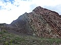
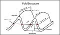
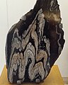
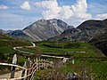
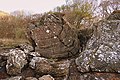
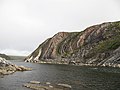
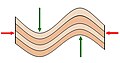
English: In geology, fold is the bending or curving of one or a stack of originally flat and planar surfaces, such as sedimentary strata, as a result of plastic (i.e. permanent) deformation.
Français : Un pli est une structure courbe issue d'une déformation ductile anisotrope de la roche.
Subcategories
This category has the following 24 subcategories, out of 24 total.
+
A
C
- Concentric folds (2 F)
D
- Detachment folds (4 F)
- Disharmonic folds (geology) (7 F)
- Drag folds (6 F)
F
- Fault bend folds (8 F)
- Folds in Old Red Sandstone (6 F)
I
M
O
- Omutnoy Stone (6 F)
P
- Ptygmatic folding (7 F)
S
- Slump folds (3 F)
Media in category "Folds"
The following 200 files are in this category, out of 205 total.
(previous page) (next page)-
 2013-08-10 16-31-01 Switzerland Cantone Ticino Brione (Verzasca) Brione.JPG 4,106 × 2,727; 7.93 MB
-
 2013-08-13 08-32-46 Switzerland Cantone Ticino Brione (Verzasca) Brione.JPG 4,288 × 2,848; 8.89 MB
-
 2022-10-28 multiple folds of green table cloth (focus stack - HiRes).jpg 9,504 × 6,336; 33.66 MB
-
 3D Fold diagram.jpg 4,235 × 1,972; 1.16 MB
-
 A Synform - geograph.org.uk - 1393565.jpg 640 × 441; 266 KB
-
 Agiospavlos DM 2004 IMG002 Felsenformation.JPG 2,048 × 1,536; 974 KB
-
 Agiospavlos DM 2004 IMG003 Felsenformation nahe.JPG 2,048 × 1,536; 1,019 KB
-
 Anticlinal fold.jpg 2,015 × 3,708; 1.7 MB
-
 Anticlinal Oil trap.png 394 × 294; 55 KB
-
 Anticline-syncline.jpg 4,608 × 2,592; 2.47 MB
-
 Antiform Synform.jpg 9,009 × 5,086; 2.67 MB
-
 Argand1.gif 1,050 × 653; 26 KB
-

-
 Barentsburg museum IMG 4493 migmatite Ny-Friesland Spitsbergen.JPG 3,456 × 2,304; 4.21 MB
-
 Barrika.jpg 1,024 × 767; 413 KB
-
 Bekhal in Holydays by Husam.Jasim.jpg 3,456 × 2,592; 8.66 MB
-
 Big Bend National Park - Ernst Tinaja Trail - panoramio.jpg 3,424 × 1,920; 3.59 MB
-
 Bråfallsstenen, 2016b.jpg 4,891 × 3,550; 5.19 MB
-
 Bulletin of the Geological Society of America (1920) (20261909220).jpg 3,456 × 2,352; 2.15 MB
-
 Bulletin of the Geological Society of America (20441795342).jpg 3,040 × 1,880; 2.35 MB
-
 Cape Orogeny A5.png 1,275 × 666; 23 KB
-
 Chalk layers in Cyprus (Paphos-Limassol) 02.jpg 1,695 × 1,112; 841 KB
-
 Chemalsky District, Altai Republic, Russia - panoramio (9).jpg 2,048 × 1,357; 656 KB
-
-
 Compressive Ridge Formation.svg 948 × 733; 2.25 MB
-
 Cumberland Narrows air.jpg 850 × 520; 151 KB
-
 Cylindrical fold.PNG 703 × 591; 281 KB
-
 Detail vom Hohen Stein bei Bad Elster.JPG 2,592 × 1,728; 2.16 MB
-
 Dextral shear folds.JPG 3,648 × 2,736; 3.33 MB
-
 Disharmonic Folding.png 688 × 366; 21 KB
-
 EB1911 - Fold - Fig. 1.png 480 × 77; 25 KB
-
 EB1911 - Fold - Fig. 2.png 512 × 393; 204 KB
-
 EB1911 - Fold - Fig. 3.png 512 × 212; 79 KB
-
 EB1911 - Fold - Fig. 4.png 329 × 148; 36 KB
-
 El-Oualdja-Khenchela-Algerie.jpg 1,024 × 766; 191 KB
-
 Eperrimont - LE GUA- Isère- France.jpg 1,280 × 960; 315 KB
-
 Erosion Mulden014.jpg 2,272 × 1,704; 1.35 MB
-
 Falde alpine.png 945 × 519; 25 KB
-
 Falde alpine.svg 945 × 500; 47 KB
-
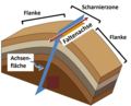
 Faltenterminologie.svg 1,283 × 609; 225 KB
-
 Fałd obalony.jpg 2,560 × 1,920; 932 KB
-
 Fig1-Lyell.jpg 175 × 73; 5 KB
-
 Fillade, da elba, cavo.JPG 2,324 × 2,060; 2.86 MB
-
 Flank & hinge German.png 1,019 × 823; 362 KB
-
 Flank & hinge.PNG 1,019 × 823; 359 KB
-
 Flysch Sediments in Basque region of Spain.jpg 4,320 × 3,240; 5.83 MB
-
 Fold 3D model.tif 4,162 × 1,865, 2 pages; 31.67 MB
-
 Fold in Cliffs at Porthtowan.jpg 3,796 × 2,800; 4.63 MB
-
 Fold model 3D .tif 4,298 × 1,972, 2 pages; 3.98 MB
-
 Fold sketch 3D model .tif 4,229 × 1,881, 2 pages; 32.44 MB
-
 Fold terminology-01.jpg 3,654 × 2,172; 629 KB
-
 Fold1.jpg 692 × 416; 81 KB
-
 Fold98.JPG 3,296 × 2,472; 1.1 MB
-
 Folded and cracked strata below Allt Wen - geograph.org.uk - 1751713.jpg 768 × 1,024; 250 KB
-
 Folded Banded Rock.jpg 4,608 × 3,456; 5.8 MB
-
 Folded beds of Liminangcong chert, Busuanga, Palawan, Philippines (narrow angle view).jpg 1,836 × 3,264; 4.04 MB
-
 Folded beds of Liminangcong chert, Busuanga, Palawan, Philippines (wide angle view) 01.jpg 3,264 × 1,836; 4.01 MB
-
-
 Folded Himalayan Rock Layers at Kali Gandaki in Nepal 2014.jpg 5,472 × 3,648; 4.8 MB
-
 Folded Himalayan Rock Layers near Gushal in India.jpg 3,872 × 2,592; 4.24 MB
-
 Folded Kanmantoo Group KI.JPG 3,072 × 2,304; 2.88 MB
-
 Folded layers of bedded chert formation in Busuanga, Palawan 01.jpg 2,604 × 4,624; 7.07 MB
-
 Folded layers of bedded chert formation in Busuanga, Palawan 02.jpg 2,604 × 4,624; 6.88 MB
-
 Folded Rock Layers Pang La Pass Tibet.jpg 1,440 × 872; 1.49 MB
-
 Folded rock, Kali Gandaki valley north of Jomsom (4524206366).jpg 1,600 × 468; 394 KB
-
 Folded Rock.jpg 480 × 640; 109 KB
-
 Folded Rocks, Ardenstur Headland - geograph.org.uk - 59021.jpg 640 × 480; 181 KB
-
 Folded Sedimentary Rock Layers Vega de Viejos in Spain.jpg 2,000 × 1,500; 462 KB
-
 Folded Strata - geograph.org.uk - 1266001.jpg 640 × 427; 238 KB
-
 Folded Strata of Pay-Khoy Ridge in Russia.jpg 4,000 × 3,000; 2.78 MB
-
 Folding - buckling and bending.jpg 800 × 421; 42 KB
-
 Folding Gasteretal.jpg 4,720 × 2,018; 2.34 MB
-
 Folds & shear in augengneiss.JPG 2,560 × 1,920; 1.24 MB
-
 Folds (4120040424).jpg 1,067 × 1,600; 746 KB
-
 Folds He 2.jpg 1,600 × 432; 141 KB
-
 Folds in Gneiss - geograph.org.uk - 1370873.jpg 480 × 640; 336 KB
-
 Folds in Lake Marble Formation in Ireland.jpg 2,048 × 1,536; 614 KB
-
 Fractured Phyllite rock of Srinagar.jpg 567 × 425; 268 KB
-
 Gesteenteplooi 2.png 1,632 × 1,224; 2.95 MB
-
 Gesteenteplooi close up.png 1,632 × 1,224; 2.15 MB
-
 Gesteenteplooi groot.png 1,632 × 1,224; 2.55 MB
-
 Gestein Faltung.JPG 2,560 × 1,920; 2.3 MB
-
 Gesteinsfaltung.JPG 2,560 × 1,920; 2.36 MB
-
 GGJ-Ph8.jpg 4,624 × 2,600; 6.2 MB
-
 Glaucophane-BlueSchist.jpg 399 × 651; 132 KB
-
 Gneiss detail.jpg 3,456 × 2,304; 2.49 MB
-
 Gneiss in Geopark on Albertov (1).JPG 3,872 × 2,581; 2.65 MB
-
 Gneiss in Geopark on Albertov (2).JPG 3,872 × 2,581; 2.65 MB
-
 GO-P18.jpg 4,624 × 2,600; 5.12 MB
-
 Goldbergkees01.08.2013 012.JPG 3,888 × 2,592; 6.98 MB
-
 Guide to common map symbols.svg 300 × 450; 18 KB
-
 Guitar and Amp (1304984799).jpg 1,315 × 822; 363 KB
-
 Haan Heinhauser Weg (Geologischer Lehrpfad) 01 13.JPG 2,560 × 1,920; 2.31 MB
-
 Inbound1576009733475117667.jpg 2,160 × 1,620; 3.02 MB
-
 Inbound2091565418343007349.jpg 1,620 × 2,160; 2.09 MB
-
 Inbound2438493171194086139.jpg 2,160 × 1,620; 3.14 MB
-
 Inbound2882268114391156146.jpg 1,620 × 2,160; 3.04 MB
-
 Inbound4675774016443142090.jpg 1,620 × 2,160; 3 MB
-
 Inbound5188418873200395071.jpg 1,620 × 2,160; 3.62 MB
-
 Isoclinal fold.JPG 2,560 × 1,920; 1.46 MB
-
 JS-Ols1.jpg 4,624 × 2,600; 5.29 MB
-
 JS-Ols2.jpg 4,624 × 2,600; 4.58 MB
-
 JS-Ols3.jpg 4,624 × 2,600; 5.21 MB
-
 KaliGandaki.jpg 1,185 × 768; 332 KB
-
 Kink band sul Dos Capel (Predazzo).jpg 1,200 × 1,600; 597 KB
-
 Kink band.jpg 247 × 328; 30 KB
-
 Kink bands.jpg 3,648 × 2,736; 3.05 MB
-
 KMds-J7.jpg 2,600 × 4,624; 3.94 MB
-
 Knudeklinten.JPG 2,112 × 2,816; 2.22 MB
-
 MarmoCipollino FustoBasMassenzioRoma.jpg 2,048 × 1,536; 1.65 MB
-
 Melierterz4-rammelsberg hg.jpg 3,461 × 2,601; 1.29 MB
-
 Metamorphic (5545176619).jpg 2,400 × 1,687; 1.8 MB
-
 Millook - geograph.org.uk - 501053.jpg 471 × 640; 97 KB
-
 Millook Haven - geograph.org.uk - 1494828.jpg 640 × 426; 92 KB
-
 Millook Haven - geograph.org.uk - 1556742.jpg 640 × 480; 70 KB
-
 Millook near Bude north Cornwall - geograph.org.uk - 93537.jpg 640 × 480; 147 KB
-
 Moddersteen, Hekpoort-formasie, a, Faerie Glen NR.jpg 4,000 × 3,000; 4.24 MB
-
 Mutilayer folds.JPG 3,072 × 2,304; 1.88 MB
-
 NAT F2foldsF1.jpg 400 × 300; 62 KB
-
 Neuschönau - Gesteins-Freigelände, Glimmer-Gneis, Gebiet nördlich des Lusen.jpg 4,000 × 3,000; 2.25 MB
-
 NP15.jpg 4,608 × 3,456; 4.5 MB
-
 Orthogneiss Geopark.jpg 3,648 × 2,485; 6.52 MB
-
 Otíñar - Plegamiento en el Barranco de la Tinaja.jpg 3,072 × 2,304; 3.64 MB
-
 Outcrop of the deformed Liminangcong chert formation in Busuanga, Palawan 01.jpg 3,264 × 1,836; 2.71 MB
-
 Outcrop of the deformed Liminangcong chert formation in Busuanga, Palawan 02.jpg 4,624 × 2,604; 6.39 MB
-
 Outcrops in Azerbaijan 7.JPG 3,072 × 2,304; 1,003 KB
-
 ParagneissFolding.jpg 3,264 × 2,448; 3.74 MB
-
 ParasiticFolds NewGlasgowNS.JPG 2,044 × 1,362; 2.7 MB
-
 Patterns in salt.JPG 1,600 × 1,200; 309 KB
-
 PeñaUbiña.jpg 3,008 × 2,000; 4.34 MB
-
 Pieghe Bellerophon ph Elena Manfrè.jpg 2,598 × 1,717; 7.9 MB
-
 Pieghe isolad'Elba.JPG 299 × 390; 39 KB
-
 PikiWiki Israel 29100 Geology of Israel.JPG 3,872 × 2,592; 3.78 MB
-
 Pine Creek Canyon boulders 1.jpg 2,400 × 1,800; 952 KB
-
 Plegamiento de Campodola.jpg 5,200 × 1,328; 3.78 MB
-
 Pliegue en Babia.JPG 2,896 × 1,944; 2.42 MB
-
 Pliegue en cofre.jpg 888 × 1,184; 381 KB
-
 Pliegue1.jpg 640 × 480; 110 KB
-
 PSM V13 D782 Fissured and folded anticlinal fold.png 784 × 288; 54 KB
-
 Ptygmatyt.jpg 1,103 × 715; 89 KB
-
 Puerto Espindola 03 ies.jpg 2,048 × 1,536; 788 KB
-
 Qeshm geology.png 1,073 × 752; 1.23 MB
-
 Ramsay Classification.PNG 289 × 439; 51 KB
-
 Recombent fold in Titus Canyon.JPG 1,143 × 828; 300 KB
-
 Recumbent Fold at Godrevy in Cornwall.jpg 3,264 × 1,840; 2.39 MB
-
 Red Rock escarpment sandstone 2.jpg 2,400 × 1,814; 1.03 MB
-
 RedRocksDistortedBeds.JPG 4,000 × 3,000; 10.24 MB
-
 Redőtípusok.jpg 1,600 × 668; 297 KB
-
 Risemedet fold in the NE flank.jpg 4,708 × 3,027; 2.23 MB
-
 Risemedet Geology.jpg 1,110 × 1,370; 190 KB
-
 Rock at ara.jpg 855 × 641; 213 KB
-
 Rock folding at St Ann's Head - geograph.org.uk - 1637353.jpg 640 × 480; 108 KB
-
 Rock strata at Millook Haven - geograph.org.uk - 1556737.jpg 480 × 640; 101 KB
-
 Rocks of Nun Kun Massif (Ladakh-India).jpg 3,072 × 2,048; 1.64 MB
-
 Sai Kung Folded Rock.JPG 4,272 × 2,848; 11.09 MB
-
 San Pedro de Atacama 1.jpg 6,000 × 4,000; 5.44 MB
-
 Sandwick Fish Bed with kink folds.jpg 2,430 × 3,239; 2.44 MB
-
 Schuifzone2.jpg 1,728 × 2,304; 1.38 MB
-
 Scuplted rock walls of the Mesa Encantada, Acoma, ca.1900 (CHS-4516).jpg 5,074 × 3,892; 1.51 MB
-
 Sinclinal in Arroyo de las Truchas.jpeg 3,072 × 4,096; 4.04 MB
-
 Slump Fold - geograph.org.uk - 474671.jpg 640 × 300; 222 KB
-
 South African Geology - Schwarz - 1912 Fig 21.png 459 × 277; 102 KB
-
 South African Geology - Schwarz - 1912 Fig 22.png 750 × 159; 80 KB
-
 South African Geology - Schwarz - 1912 Fig 24.png 816 × 306; 258 KB
-
 South African Geology - Schwarz - 1912 Fig 26.png 813 × 414; 166 KB
-
 South African Geology - Schwarz - 1912 Fig 28.png 843 × 327; 169 KB
-
 Studies in minor folds (IA studiesinminorfo00deckrich).pdf 885 × 1,341, 110 pages; 9.5 MB
-
 Swartberg Pass Rock Formation.JPG 800 × 536; 273 KB
-
 Synclinal Deflection.GIF 666 × 334; 22 KB
-
 Temagami BIF fold.jpg 768 × 576; 90 KB
-
 Tuff ring Caldera Blanca on Lanzarote, June 2013 (6).jpg 4,752 × 3,168; 6.94 MB
-
 UlvikfjordMountainsPanorama.jpg 2,437 × 1,200; 2.16 MB
-
 Uummannaq-mountain-southern-wall.jpg 3,872 × 2,176; 3.5 MB
-
 Valle de Aisa, El Rigüelo (Nacimiento del río Estarrún) - WLE Spain 2015 (2).jpg 1,200 × 900; 2.14 MB
-
 Valle de Aísa. El Rigüelo (Nacimiento del río Estarrún) - WLE Spain 2015 (16).jpg 1,200 × 900; 1.53 MB
-
 Valle de Aísa. El Rigüelo (Nacimiento del río Estarrún) - WLE Spain 2015 (18).jpg 900 × 1,200; 1.67 MB
-
 Valle de Aísa. El Rigüelo (Nacimiento del río Estarrún) - WLE Spain 2015 (20).jpg 1,200 × 900; 1.43 MB
-
 Valle de Aísa. El Rigüelo (Nacimiento del río Estarrún) - WLE Spain 2015 (21).jpg 1,200 × 900; 1.32 MB
-
 Valle de Aísa. El Rigüelo (Nacimiento del río Estarrún) - WLE Spain 2015 (23).jpg 1,200 × 750; 1.13 MB
-
 Valle de Aísa. El Rigüelo (Nacimiento del río Estarrún) - WLE Spain 2015 (24).jpg 1,200 × 900; 1.26 MB
-
 Valle de Aísa. El Rigüelo (Nacimiento del río Estarrún) - WLE Spain 2015 (25).jpg 900 × 1,200; 1.41 MB
-

-
 Valle de Aísa. El Rigüelo (Nacimiento del río Estarrún) - WLE Spain 2015 (27).jpg 1,200 × 900; 1.19 MB
-
 Valle de Aísa. El Rigüelo (Nacimiento del río Estarrún) - WLE Spain 2015 (28).jpg 1,200 × 750; 1.07 MB
-
 Valle de Aísa. El Rigüelo (Nacimiento del río Estarrún) - WLE Spain 2015 (29).jpg 1,200 × 900; 1.25 MB
-
 Valle de Aísa. El Rigüelo (Nacimiento del río Estarrún) - WLE Spain 2015 (30).jpg 1,200 × 900; 1.29 MB
-
 Valle de Aísa. El Rigüelo (Nacimiento del río Estarrún) - WLE Spain 2015 (38).jpg 1,200 × 900; 1.68 MB
-
 Valle de Aísa. El Rigüelo (Nacimiento del río Estarrún) - WLE Spain 2015 (39).jpg 1,200 × 675; 1.36 MB
-
 Valle de Aísa. El Rigüelo (Nacimiento del río Estarrún) - WLE Spain 2015 (40).jpg 1,200 × 900; 1.65 MB
-
 Valle de Aísa. El Rigüelo (Nacimiento del río Estarrún) - WLE Spain 2015 (42).jpg 1,200 × 675; 1.16 MB
-
 Valle de Aísa. El Rigüelo (Nacimiento del río Estarrún) - WLE Spain 2015 (44).jpg 1,200 × 900; 1.65 MB
-
 Valle de Aísa. El Rigüelo (Nacimiento del río Estarrún) - WLE Spain 2015 (52).jpg 1,200 × 900; 1.62 MB
-
 Valle de Aísa. El Rigüelo (Nacimiento del río Estarrún) - WLE Spain 2015.jpg 1,200 × 900; 2.15 MB
-
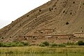 Village in Aït Bouguemez.jpg 3,456 × 2,304; 2.44 MB
-
 Vrásněná hornina.jpg 450 × 600; 90 KB
-
 Wave-cut platform below Allt Wen - geograph.org.uk - 1748657.jpg 768 × 1,024; 200 KB
-
 Wave-cut platform below Allt Wen - geograph.org.uk - 1750017.jpg 1,024 × 768; 516 KB
-
 Zibans SPOT 1193.jpg 500 × 500; 114 KB
-
 Roadside rocks - geograph.org.uk - 525108.jpg 480 × 640; 137 KB
-
 Çaltepe 13 09 2000 Gebirgsfaltung.jpg 2,703 × 1,733; 1.85 MB
_Brione.JPG)
_Brione.JPG)
.jpg)


_(20261909220).jpg)
.jpg)

_02.jpg)
.jpg)


.jpg)
_01.jpg)


.jpg)


.JPG)
.JPG)


.jpg)
_01_13.JPG)


.jpg)


.jpg)


.jpg)


.jpg)


.jpg)


_-_WLE_Spain_2015_(2).jpg)
_-_WLE_Spain_2015_(16).jpg)
_-_WLE_Spain_2015_(18).jpg)
_-_WLE_Spain_2015_(20).jpg)
_-_WLE_Spain_2015_(21).jpg)
_-_WLE_Spain_2015_(23).jpg)
_-_WLE_Spain_2015_(24).jpg)
_-_WLE_Spain_2015_(25).jpg)
_-_WLE_Spain_2015_(26).jpg)
_-_WLE_Spain_2015_(27).jpg)
_-_WLE_Spain_2015_(28).jpg)
_-_WLE_Spain_2015_(29).jpg)
_-_WLE_Spain_2015_(30).jpg)
_-_WLE_Spain_2015_(38).jpg)
_-_WLE_Spain_2015_(39).jpg)
_-_WLE_Spain_2015_(40).jpg)
_-_WLE_Spain_2015_(42).jpg)
_-_WLE_Spain_2015_(44).jpg)
_-_WLE_Spain_2015_(52).jpg)
_-_WLE_Spain_2015.jpg)


.jpg)