Category:Harringworth
Jump to navigation
Jump to search
village and civil parish in Northamptonshire, UK  | |||||
| Upload media | |||||
| Instance of | |||||
|---|---|---|---|---|---|
| Standort | North Northamptonshire, Northamptonshire, East Midlands, England | ||||
| Population |
| ||||
| Said to be the same as | Harringworth (Wikimedia duplicated page, civil parish) | ||||
 | |||||
Subcategories
This category has the following 11 subcategories, out of 11 total.
C
H
- Harringworth Lodge (3 F)
- Harringworth railway station (2 F)
M
- Harringworth Market Cross (3 F)
R
V
- Welland Viaduct (40 F)
W
- The White Swan, Harringworth (6 F)
Z
- Zouche (of Harringworth) arms (16 F)
Media in category "Harringworth"
The following 200 files are in this category, out of 249 total.
(previous page) (next page)-
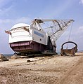 1980 - RANSOMES RAPIER W1400 DRAGLINE 'SUNDEW' HARRINGWORTH QUARRY 14-04-1980 (8).jpg 2,491 × 2,528; 1.41 MB
-
 A narrow walkway - geograph.org.uk - 4915691.jpg 960 × 1,280; 387 KB
-

-
 Across the Welland - geograph.org.uk - 4220295.jpg 859 × 997; 946 KB
-
 Across the Welland Valley - geograph.org.uk - 1919764.jpg 800 × 600; 162 KB
-
 Across the Welland Valley - geograph.org.uk - 1919770.jpg 800 × 600; 156 KB
-
 Alongside Spanhoe Wood - geograph.org.uk - 5980234.jpg 768 × 1,024; 288 KB
-
 An almost Turtle bridge - geograph.org.uk - 1745350.jpg 4,000 × 3,000; 3.08 MB
-

-
 Any road vehicle striking this bridge . . . - geograph.org.uk - 4915697.jpg 1,280 × 960; 391 KB
-

-
 Barn in Spanhoe wood - geograph.org.uk - 1286218.jpg 640 × 480; 101 KB
-
 Bean field near Harringworth - geograph.org.uk - 6567836.jpg 1,024 × 768; 220 KB
-
 Belwick estate's permitted path - geograph.org.uk - 3083528.jpg 1,024 × 768; 210 KB
-
 Between two woods - geograph.org.uk - 6565232.jpg 1,024 × 768; 237 KB
-

-
 Bridleway near Harringworth Lodge - geograph.org.uk - 6564432.jpg 1,024 × 768; 223 KB
-
 Bridleway near Harringworth Lodge - geograph.org.uk - 6565154.jpg 1,024 × 750; 143 KB
-
 Bridleway near Harringworth Lodge - geograph.org.uk - 6565164.jpg 1,024 × 768; 156 KB
-
 Bridleway sign - geograph.org.uk - 5990371.jpg 640 × 438; 81 KB
-
 Bridleway through a field of mustard - geograph.org.uk - 6564426.jpg 1,024 × 768; 248 KB
-
 Bridleway to the south - geograph.org.uk - 5990372.jpg 640 × 441; 100 KB
-
 Bridleway towards Laxton - geograph.org.uk - 6562206.jpg 1,024 × 768; 117 KB
-
 Bridleway towards the Harringworth-Wakerley road - geograph.org.uk - 6471157.jpg 3,776 × 2,520; 3.94 MB
-
 Buzzed by buzzards - geograph.org.uk - 4183570.jpg 640 × 427; 50 KB
-
 Byway sign - geograph.org.uk - 5990373.jpg 640 × 529; 135 KB
-
 Byway to the north - geograph.org.uk - 5990374.jpg 640 × 490; 109 KB
-
 Byway to Turtle Bridge - geograph.org.uk - 6558995.jpg 1,024 × 768; 216 KB
-
 Coming to the end of a wheat field - geograph.org.uk - 6564405.jpg 1,024 × 768; 211 KB
-
 Concrete drainage gully - geograph.org.uk - 1834784.jpg 3,648 × 2,736; 2.22 MB
-
 Concrete Road near Harringworth Lodge - geograph.org.uk - 6564387.jpg 1,024 × 768; 196 KB
-
 Concrete roadway alongside a small wooded area - geograph.org.uk - 6565865.jpg 1,024 × 768; 185 KB
-
 Construction work, The Warren - geograph.org.uk - 6567776.jpg 1,024 × 768; 324 KB
-
 Course of a former mineral railway - geograph.org.uk - 6565546.jpg 1,024 × 768; 297 KB
-
 Course of a former mineral railway - geograph.org.uk - 6565555.jpg 1,024 × 768; 389 KB
-
 Course of a former mineral railway - geograph.org.uk - 6565914.jpg 1,024 × 768; 183 KB
-
 Course of a former mineral railway - geograph.org.uk - 6565915.jpg 1,024 × 768; 210 KB
-
 Course of a former mineral railway - geograph.org.uk - 6565917.jpg 1,024 × 768; 133 KB
-
 Course of the River Welland - geograph.org.uk - 460172.jpg 640 × 480; 121 KB
-
 Daffodils near the Harringworth Viaduct - geograph.org.uk - 4878835.jpg 800 × 669; 149 KB
-

-

-
 Deene Road in Harringworth - geograph.org.uk - 4878772.jpg 800 × 577; 115 KB
-
 Disused barn near Shotley - geograph.org.uk - 6561956.jpg 1,024 × 768; 169 KB
-
 Disused railway looking ENE - geograph.org.uk - 461317.jpg 480 × 640; 116 KB
-
 Disused railway looking WSW - geograph.org.uk - 461315.jpg 640 × 480; 116 KB
-
 Ditch, grass and willows - geograph.org.uk - 6565241.jpg 1,024 × 768; 210 KB
-
 Driveway to Netherfield Farm - geograph.org.uk - 5990367.jpg 640 × 473; 115 KB
-

-
 Dutch barn near Shotley - geograph.org.uk - 1741372.jpg 3,648 × 2,736; 2.22 MB
-
 Entering Rutland at the Welland Viaduct - geograph.org.uk - 2902113.jpg 1,067 × 1,600; 345 KB
-
 Entrance to permitted path - geograph.org.uk - 3083521.jpg 1,024 × 768; 261 KB
-
 Entrance to Spanhoe Airfield - geograph.org.uk - 6079020.jpg 3,776 × 2,520; 3.82 MB
-
 Equine jump - geograph.org.uk - 1286250.jpg 640 × 480; 99 KB
-
 Farm buildings at Shotley - geograph.org.uk - 1741405.jpg 3,648 × 2,736; 2.16 MB
-
 Farm track near Harringworth Lodge - geograph.org.uk - 6565920.jpg 1,024 × 768; 152 KB
-
 Farm track off Harringworth Road - geograph.org.uk - 6567838.jpg 1,024 × 827; 157 KB
-
 Farm track off the Harringworth Road - geograph.org.uk - 3886428.jpg 640 × 480; 486 KB
-

-
 Field access bridge - geograph.org.uk - 1741326.jpg 3,648 × 2,736; 2.16 MB
-
 Field edge near Harringworth Lodge - geograph.org.uk - 6565872.jpg 1,024 × 768; 165 KB
-
 Field entrance near Harringworth Lodge - geograph.org.uk - 6565159.jpg 1,024 × 768; 296 KB
-
 Field off the Harringworth Road - geograph.org.uk - 3886427.jpg 640 × 480; 456 KB
-
 Flat countryside west of Laxton - geograph.org.uk - 6257712.jpg 1,600 × 1,002; 645 KB
-

-

-

-

-
 Footpath across a grass field - geograph.org.uk - 6565943.jpg 1,024 × 768; 173 KB
-
 Footpath through a field of ripening wheat - geograph.org.uk - 6565925.jpg 1,024 × 768; 162 KB
-
 Footpath through a wheatfield at Shotley - geograph.org.uk - 6564369.jpg 1,024 × 768; 207 KB
-
 Footpath through Spanhoe Wood - geograph.org.uk - 6079047.jpg 3,776 × 2,520; 4.32 MB
-
 Footpath to Gretton - geograph.org.uk - 6565870.jpg 1,024 × 768; 163 KB
-
 Former quarry site at the west end of Wakerley Great Wood - geograph.org.uk - 6471172.jpg 3,776 × 2,520; 4.13 MB
-
-
 Gap between Household Coppice and Hollow Wood - geograph.org.uk - 6565503.jpg 1,024 × 768; 229 KB
-
 Gap in the trees - geograph.org.uk - 6565520.jpg 1,024 × 768; 221 KB
-
 Gate to Station Farm, Harringworth - geograph.org.uk - 3886429.jpg 640 × 480; 482 KB
-
 Gated farm track entrance - geograph.org.uk - 3083539.jpg 991 × 744; 548 KB
-
 Glimpse of Harringworth Lodge - geograph.org.uk - 6565231.jpg 1,024 × 768; 233 KB
-
 Grass field and farm track near Dryleas Wood - geograph.org.uk - 6564421.jpg 1,024 × 768; 199 KB
-
 Grass field and plantation - geograph.org.uk - 6565937.jpg 1,024 × 768; 158 KB
-
 Grass field and Welland Viaduct - geograph.org.uk - 6565641.jpg 1,024 × 768; 219 KB
-
 Grass field below Dryleas Wood - geograph.org.uk - 6565517.jpg 1,024 × 768; 184 KB
-
 Grass field near Harringworth - geograph.org.uk - 6565647.jpg 1,024 × 768; 157 KB
-

-
 Grazing sheep near Wakerley - geograph.org.uk - 6559024.jpg 1,024 × 768; 154 KB
-
 Green lane - geograph.org.uk - 461312.jpg 640 × 480; 127 KB
-
 Gretton Road towards Gretton - geograph.org.uk - 5990368.jpg 640 × 445; 87 KB
-
 Gretton Road towards Harringworth - geograph.org.uk - 5990369.jpg 640 × 420; 71 KB
-
 Hamlet of Shotley - geograph.org.uk - 1826341.jpg 4,000 × 3,000; 2.89 MB
-
 Harrington to Laxton road at Spanhoe - geograph.org.uk - 4915680.jpg 1,280 × 845; 323 KB
-
 County boundary - geograph.org.uk - 460199.jpg 640 × 480; 136 KB
-

-
 Harringworth Northants - Flickr - mick - Lumix.jpg 3,177 × 2,162; 3.35 MB
-
 Harringworth Road - geograph.org.uk - 6567834.jpg 1,024 × 768; 237 KB
-
 Harringworth Road near Harringworth - geograph.org.uk - 5199775.jpg 363 × 640; 46 KB
-
 Harringworth Viaduct - panoramio.jpg 2,370 × 1,392; 1.5 MB
-
 Harringworth Viaduct, Northants - geograph.org.uk - 1822908.jpg 800 × 555; 116 KB
-
 Harringworth water pumping station - geograph.org.uk - 4915684.jpg 1,280 × 865; 242 KB
-
 Harringworth, Manor Farm - geograph.org.uk - 4219995.jpg 1,024 × 768; 1.1 MB
-
 Harringworth, paddock and spire - geograph.org.uk - 4219547.jpg 1,024 × 682; 821 KB
-
 Harringworth, village view - geograph.org.uk - 1286261.jpg 640 × 480; 85 KB
-
 Harringworth, Wakerley Road - geograph.org.uk - 4219578.jpg 1,024 × 682; 893 KB
-
 Harringworth-Seaton-Welland Viaduct - geograph.org.uk - 4089299.jpg 640 × 426; 65 KB
-
 Hay field near Dryleas Wood - geograph.org.uk - 6565526.jpg 1,024 × 768; 201 KB
-
 Horses on the Jurassic Way - geograph.org.uk - 2450613.jpg 4,000 × 3,000; 4.07 MB
-
 Horses over the border - geograph.org.uk - 3082906.jpg 1,024 × 768; 116 KB
-
 Interior of St John the Baptist Church, Harringworth - geograph.org.uk - 5004863.jpg 4,316 × 3,238; 2.02 MB
-
 Jurassic wall of May - geograph.org.uk - 1826386.jpg 4,000 × 3,000; 3.04 MB
-
 Jurassic Way down to the Welland Valley - geograph.org.uk - 1826355.jpg 4,000 × 3,000; 2.61 MB
-

-

-

-

-
 Jurassic Way towards Harringworth Lodge - geograph.org.uk - 1826406.jpg 4,000 × 3,000; 2.93 MB
-
 Just about half . . . - geograph.org.uk - 4915374.jpg 1,280 × 852; 264 KB
-
 Lake at Harringworth Lodge - geograph.org.uk - 6565152.jpg 1,024 × 706; 126 KB
-
 Laxton bridleway - geograph.org.uk - 5980238.jpg 768 × 1,024; 158 KB
-
 Leaving Spanhoe Wood - geograph.org.uk - 5980237.jpg 1,024 × 768; 319 KB
-
 Makers' plate on opensided barn - geograph.org.uk - 5990376.jpg 640 × 614; 117 KB
-
 Market Cross, Harringworth - geograph.org.uk - 6545464.jpg 4,320 × 3,240; 2.96 MB
-
 Meadow next to Short Wood - geograph.org.uk - 6471185.jpg 3,776 × 2,520; 3.87 MB
-

-
 Minor road heading for Harringworth - geograph.org.uk - 5786623.jpg 2,592 × 1,944; 1.45 MB
-
 Minor road west of Laxton - geograph.org.uk - 5786610.jpg 2,592 × 1,944; 1.23 MB
-
 Motor car prohibition sign - geograph.org.uk - 5990377.jpg 640 × 503; 84 KB
-

-
 Mustard field - geograph.org.uk - 6565183.jpg 1,024 × 768; 251 KB
-
 Netherfield Farm driveway - geograph.org.uk - 5990366.jpg 640 × 454; 106 KB
-
 Netherfield Farm signs - geograph.org.uk - 5990370.jpg 640 × 336; 74 KB
-

-

-

-

-

-
 On the Jurassic Way at Turtle Bridge, NE of Harringworth - geograph.org.uk - 5245393.jpg 5,184 × 2,920; 5.68 MB
-
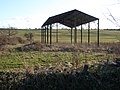
 Open sided barn - geograph.org.uk - 5990378.jpg 640 × 429; 77 KB
-
 Owl box and grass field - geograph.org.uk - 6565536.jpg 1,024 × 768; 257 KB
-
 Path east towards Wakerley Great Wood - geograph.org.uk - 6471178.jpg 3,776 × 2,520; 3.87 MB
-
 Path to St John the Baptist Church, Harringworth - geograph.org.uk - 5004845.jpg 4,608 × 3,456; 3.37 MB
-
 Permitted path and greening hardstanding - geograph.org.uk - 3083535.jpg 1,024 × 768; 273 KB
-
 Picnic site by the Harringworth Road - geograph.org.uk - 3886422.jpg 640 × 480; 498 KB
-
 Post box - geograph.org.uk - 5628183.jpg 4,014 × 6,032; 6.12 MB
-
 Railway bridge over Gretton Road - geograph.org.uk - 6567841.jpg 1,024 × 768; 205 KB
-
 Redundant stile - geograph.org.uk - 6564396.jpg 1,024 × 768; 216 KB
-
 Reed bed in the Welland - geograph.org.uk - 1741252.jpg 3,648 × 2,736; 2.2 MB
-
 Remains of a hedge - geograph.org.uk - 6565506.jpg 1,024 × 768; 223 KB
-
 Right for Deene outside Spanhoe Airfield - geograph.org.uk - 3083549.jpg 1,024 × 768; 127 KB
-
 Rights of way crossing the Harringworth to Wakerley road - geograph.org.uk - 6471154.jpg 3,776 × 2,520; 3.91 MB
-

-
 River Welland and the Welland Viaduct - geograph.org.uk - 3886434.jpg 640 × 480; 540 KB
-
 Road Junction at Spanhoe Airfield - geograph.org.uk - 3365455.jpg 640 × 438; 32 KB
-
 Road near Spanhoe - geograph.org.uk - 5199786.jpg 480 × 640; 62 KB
-
 Road to Laxton - geograph.org.uk - 5199778.jpg 480 × 640; 52 KB
-
 Road to Laxton - geograph.org.uk - 5199788.jpg 480 × 640; 41 KB
-
 Seaton Road approaches Rutland and the Welland Viaduct - geograph.org.uk - 2450651.jpg 4,000 × 3,000; 4.13 MB
-
 Seaton Road in Harringworth - geograph.org.uk - 4878791.jpg 800 × 590; 134 KB
-
 Seaton to Harringworth - geograph.org.uk - 5280233.jpg 1,024 × 768; 1.2 MB
-
 Sheep pasture near Gretton - geograph.org.uk - 6565559.jpg 1,024 × 768; 215 KB
-
 Sheep pasture near Gretton - geograph.org.uk - 6565949.jpg 1,024 × 768; 187 KB
-
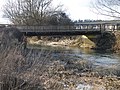
 Small bridge on Seaton Road - geograph.org.uk - 3082892.jpg 1,024 × 768; 166 KB
-
 Small bridge on Seaton Road - geograph.org.uk - 3082898.jpg 1,024 × 768; 115 KB
-
 Spanhoe Airfield memorial - geograph.org.uk - 3365457.jpg 640 × 570; 116 KB
-
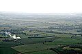
 Spanhoe airfield, aerial 2014 - geograph.org.uk - 4055018.jpg 640 × 427; 51 KB
-
 Spanhoe airfield, aerial 2014 - geograph.org.uk - 4055022.jpg 640 × 427; 51 KB
-
 Spanhoe Lodge near Spanhoe Airfield - geograph.org.uk - 4877999.jpg 800 × 531; 98 KB
-
 Spanhoe War Memorial - geograph.org.uk - 5199785.jpg 640 × 480; 126 KB
-
 Spanhoe Wood - geograph.org.uk - 5980235.jpg 768 × 1,024; 331 KB
-
 Spanhoe, camping on the airfield - geograph.org.uk - 4183575.jpg 640 × 427; 55 KB
-
 Spring time on the Jurassic Way - geograph.org.uk - 1741478.jpg 3,648 × 2,736; 2.19 MB
-
 Steps over a wall - geograph.org.uk - 6565889.jpg 1,024 × 768; 213 KB
-
 Stile and gap in the hedge - geograph.org.uk - 6565947.jpg 1,024 × 768; 261 KB
-
 Stile on a footpath from Gretton - geograph.org.uk - 6564413.jpg 1,024 × 768; 228 KB
-
 Stone yard at Spanhoe Airfield - geograph.org.uk - 4183568.jpg 640 × 427; 75 KB
-
 Thank you again Bulwick Estates - geograph.org.uk - 1826451.jpg 4,000 × 3,000; 2.87 MB
-
 The entrance to Spanhoe Airfield - geograph.org.uk - 4915669.jpg 1,280 × 960; 477 KB
-
 The entrance to Spanhoe Airfield - geograph.org.uk - 4915673.jpg 960 × 1,280; 511 KB
-
 The Harringworth Viaduct - geograph.org.uk - 4878811.jpg 677 × 800; 114 KB
-
 The Jurassic Way leading north from Haringworth Lodge - geograph.org.uk - 3849521.jpg 3,776 × 2,520; 4.16 MB
-
 The Jurassic Way leading towards Gretton - geograph.org.uk - 3849548.jpg 3,776 × 2,520; 3.85 MB
-
 The Jurassic Way near Gretton - geograph.org.uk - 6565960.jpg 1,024 × 768; 201 KB
-
 The Jurassic Way near Harringworth - geograph.org.uk - 6564372.jpg 1,024 × 768; 123 KB
-
 The Jurassic Way towards Harringworth - geograph.org.uk - 6565903.jpg 1,024 × 768; 179 KB
-
 The River Welland and the Welland Viaduct - geograph.org.uk - 5786646.jpg 2,592 × 1,944; 2.31 MB
-
 The River Welland looking across into Rutland - geograph.org.uk - 2450584.jpg 4,000 × 3,000; 4.15 MB
-
 The River Welland upriver of Turtle Bridge - geograph.org.uk - 2448466.jpg 4,000 × 3,000; 3.99 MB
-
 The road to Laxton - geograph.org.uk - 3082911.jpg 1,024 × 768; 158 KB
-
 The Tryon Vault, St John the Baptist Church, Harringworth - geograph.org.uk - 5004876.jpg 4,313 × 3,235; 2.52 MB
-
 The Welland Meadows and the Welland Viaduct - geograph.org.uk - 2450599.jpg 4,000 × 3,000; 3.98 MB
-
 The Welland near Harringworth - geograph.org.uk - 6469025.jpg 3,776 × 2,520; 4.1 MB
-
 The Welland Railway Viaduct as seen from Seaton Road - geograph.org.uk - 6428106.jpg 1,802 × 1,201; 468 KB
-
 The Welland Valley - geograph.org.uk - 6471149.jpg 3,776 × 2,520; 4.16 MB
-
 Through the arches - geograph.org.uk - 4915687.jpg 1,280 × 811; 213 KB
-
 Towards Barrowden - geograph.org.uk - 4220317.jpg 1,024 × 768; 954 KB
-
 Towards Harringworth - geograph.org.uk - 3365461.jpg 640 × 476; 55 KB
-
 Towards Harringworth - geograph.org.uk - 4220066.jpg 1,024 × 768; 1.01 MB
-
 Towards Harringworth spire - geograph.org.uk - 4219536.jpg 1,024 × 1,024; 1.24 MB
-
 Towards Wakerley - geograph.org.uk - 5990382.jpg 640 × 463; 73 KB
-
 Track alongside the lake - geograph.org.uk - 6565229.jpg 1,024 × 768; 198 KB
.jpg)


