<nowiki>Category:Maps of Dartmoor; categoría de Wikimedia; kategori Wikimedia; Wikimedia category; د ويکيمېډيا وېشنيزه; Vikimedya kategorisi; ویکیمیڈیا زمرہ; kategória projektov Wikimedia; категорія проєкту Вікімедіа; 维基媒体分类; Wikimedia-Kategorie; Викимедиина категорија; Wikimedia-Kategorie; विकिपीडिया:श्रेणी; page de catégorie de Wikimedia; kategorija na Wikimediji; विकिपीडिया वर्ग; категорија на Викимедији; Wikimedia-Kategorie; Wikimedia-kategori; kategori Wikimédia; تصنيف ويكيميديا; pajenn rummata eus Wikimedia; Wikimedia:ကဏ္ဍခွဲခြင်း; 維基媒體分類; Wikimedia категориясы; categoría de Wikimedia; Wikimedia-categorie; Wikimedia-Kategorie; tudalen categori Wikimedia; kategori e Wikimedias; ردهٔ ویکیپدیا; 维基媒体分类; Wikimedia-kategory; ვიკიპედია:კატეგორიზაცია; ウィキメディアのカテゴリ; categoria Wikimedia; تصنيف بتاع ويكيميديا; විකිමීඩියා ප්රභේද පිටුව; categoria Vicimediorum; विकिमीडिया वर्गः; विकिमीडिया श्रेणी; Wikimedia-luokka; Wikimedia category; விக்கிமீடியப் பகுப்பு; катэгорыя ў праекце Вікімэдыя; Викимедиа проектындагы төркем; catigurìa di nu pruggettu Wikimedia; หน้าหมวดหมู่วิกิมีเดีย; Wikimedia:Kategorija; Wikimedia-Kategorie; Wikimedia:Klassys; категория на Уикимедия; categorie a unui proiect Wikimedia; categurìa 'e nu pruggette Wikimedia; Wikimedia-kategori; kawan Wikimèdia; 維基媒體分類; 위키미디어 분류; Wikimedia-bólkur; kategorio en Vikimedio; kategori Wikimedia; Wikimedia:Ronnaghys; উইকিমিডিয়া বিষয়শ্রেণী; kategori Wikimedia; 维基媒体分类; וויקימעדיע קאַטעגאָריע; kategorija w projektach Wikimedije; thể loại Wikimedia; Wikimedia projekta kategorija; kategoria ti Wikimedia; categoria de um projeto da Wikimedia; 维基媒体分类; категорияд Ангилал; Wikimedia-kategori; kategori Wikimedia; پۆلی ویکیمیدیا; Wikimedia category; Vikimédia ñemohenda; Wikimédia-kategória; વિકિપીડિયા શ્રેણી; Wikimediako kategoria; категория в проекте Викимедиа; Wikimedia-Kategorie; катэгорыя ў праекце Вікімедыя; Wikimedia-kategorie; Wîkîmediya:Kategorî; विकिमिडिया श्रेणी; Wikimedia-Kategorie; קטגוריה במיזמי ויקימדיה; Викимедиа проектындагы төркем; Wikimedia-Kategorie; κατηγορία εγχειρημάτων Wikimedia; विकिमिडिया श्रेणी; Wikimedia-kategoriija; гурӯҳи Викимедиа; Wikimedia kategooria; categoría de Wikimedia; kategoria w projekcie Wikimedia; categoria di un progetto Wikimedia; 維基媒體分類; Wikimedia category; Viciméid catagóir; 維基媒體分類; 維基媒體分類; Վիքիմեդիայի նախագծի կատեգորիա; kategorya ng Wikimedia; гурӯҳи Викимедиа; ẹ̀ka Wikimedia; kategorie na projektech Wikimedia; categoria de um projeto da Wikimedia; kategorija na Wikimediji; Kategoriya ning Wikimedia; tumbung Wikimedia; categoria de Wikimedia; kategorija Wikimedie; Wikimedia proyektındağı törkem; Wikimedia-kategorie; Vikipidiya:Shopni; kategori Wikimedia; jamii ya Wikimedia; വിക്കിമീഡിയ വർഗ്ഗം; Wikimedia-categorie; kategori Wikimedia; Wikimedia-categorie; زمرو:وڪيپيڊيا زمرا بندي; Викимедиа категорияһы; categoría de Wikimedia; Wikimedia-kategori; 维基媒体分类; guruhi Vikimedia</nowiki>


 Ordnance Survey Drawings - Dartmoor (OSD 23).jpg 4,000 × 1,937; 3.16 MB


 Dartmoor National Park map.svg 1,208 × 1,187; 469 KB
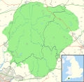 Dartmoor National Park UK location map.svg 1,208 × 1,187; 892 KB
 Dartmoor National Park UK relief location map.png 2,002 × 1,968; 2.46 MB
 Dartmoor topographic map.svg 2,000 × 1,964; 15.26 MB
 Devonport Leat map.png 2,000 × 1,993; 2.43 MB
 Drizzlecombe map01.svg 2,014 × 1,477; 117 KB
 Drizzlecombe map02.png 2,014 × 1,477; 210 KB
 Eylesbarrow mine plan01.gif 800 × 746; 87 KB
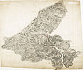 Ordnance Survey Drawings - Dartmoor, Devon (OSD 22).jpg 4,961 × 4,206; 4.25 MB
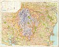 Ordnance Survey One-Inch Tourist Map of Dartmoor Published 1967.jpg 12,489 × 9,917; 18.61 MB
 Ordnance Survey Sheet SX 85 (20 85) Dartmouth, Published 1948.jpg 7,616 × 8,862; 14.9 MB
 The Quarterly journal of the Geological Society of London (1904) (14598464728).jpg 3,408 × 2,128; 904 KB
.jpg)
_cropped_to_show_Greenway.jpg)


.jpg)

_Dartmouth,_Published_1948.jpg)
_(14598464728).jpg)
%27_(11202568733).jpg)
.jpg)
.jpg)
%27_(11205934265).jpg)