Category:Maps showing 8th-century history
Jump to navigation
Jump to search
| Preceded by: 7th century maps |
8th century maps 701 AD-800 AD |
Succeeded by: 9th century maps |
Subcategories
This category has the following 11 subcategories, out of 11 total.
Media in category "Maps showing 8th-century history"
The following 36 files are in this category, out of 36 total.
-
 133 of 'Cassell's Illustrated Universal History' (11154803036).jpg 1,969 × 1,915; 997 KB
-
 Abbasid Caliphate (greatest extent).svg 553 × 553; 296 KB
-
 Abbasid Caliphate most extant.png 800 × 487; 85 KB
-
 Abbasid Caliphate most extant.svg 2,471 × 1,402; 252 KB
-
 An Lushan Rebellion-zh.png 1,275 × 902; 125 KB
-
 Arab Caliphate.jpg 888 × 674; 220 KB
-
 Arab Caliphate.svg 350 × 334; 1.04 MB
-
 Arabia Eighth Century-pt.svg 850 × 650; 1.38 MB
-
 Awarenmark-frankenreich-es.svg 1,348 × 1,320; 1.33 MB
-
 Awarenmark-frankenreich.png 450 × 450; 67 KB
-
 Battle of Marcellae.png 1,485 × 1,445; 857 KB
-
 Beonna coins map.svg 540 × 620; 417 KB
-
 Buta ul.png 1,052 × 868; 70 KB
-
 Byzantine–Bulgarian Wars (741-775).png 1,218 × 2,089; 2.33 MB
-
 Carte monde Maya 800.jpg 3,072 × 2,287; 930 KB
-
 Dawn of Islam (after 100 A.H).JPG 3,109 × 2,448; 1.48 MB
-
 Dawn of Islam.jpg 3,109 × 2,448; 1.48 MB
-
 Empires voies commerciales.jpg 663 × 500; 169 KB
-
 Frankenreich 768-811.jpg 1,400 × 1,180; 261 KB
-
 Frankish Empire (orthographic projection).svg 551 × 550; 735 KB
-
 Map of the Second Turkic Khaganate.png 3,196 × 1,840; 13.39 MB
-
 Muhallabids Dynasty 771-793 (AD).PNG 821 × 440; 33 KB
-
 Muhammad bin Qasim's expedition into Sindh.png 527 × 402; 14 KB
-
 Old Arab World map (old Russian).jpg 569 × 341; 75 KB
-
 Revolt.png 1,507 × 945; 876 KB
-
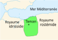 Royaume sufrite de Tlemcen.svg 178 × 122; 12 KB
-
 Slav-7-8-obrez.jpg 3,051 × 3,359; 2.51 MB
-
 Slavic Tribes in the 7th to 9th century PL.svg 902 × 903; 1.47 MB
-
 Slavic tribes in the 7th to 9th century-es.svg 14,013 × 11,983; 1.72 MB
-
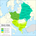 Slavic tribes in the 7th to 9th century.svg 512 × 513; 1.63 MB
-
 Verlauf der Via Amerina im Byzantinischen Korridor.jpg 1,484 × 1,765; 647 KB
-

-
 Verlauf der Via Amerina von Rom nach Rimini.jpg 686 × 1,244; 237 KB
-
-
 خارطة الدولة الأموية.png 2,554 × 1,937; 264 KB
-
 倭馬亞王朝版圖.svg 889 × 853; 1.4 MB
.jpg)
.svg)


.png)

.JPG)


.svg)

.PNG)

.jpg)


