Category:Threestoneburn Stone Circle
Jump to navigation
Jump to search
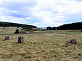
archaeological site in Northumberland, England, UK  | |||||
| Upload media | |||||
| Instance of | |||||
|---|---|---|---|---|---|
| Location | Ilderton, Northumberland, North East England, England | ||||
| Heritage designation |
| ||||
 | |||||
Media in category "Threestoneburn Stone Circle"
The following 4 files are in this category, out of 4 total.
-

-
 Threestone Burn stone circle - geograph.org.uk - 384800.jpg 640 × 480; 121 KB
-
 Threestoneburn Stone Circle - geograph.org.uk - 1836990.jpg 1,024 × 768; 240 KB
-
 Threestoneburn Stone Circle - geograph.org.uk - 1837117.jpg 1,024 × 768; 356 KB


