Uploads by Huebi~commonswiki
Jump to navigation
Jump to search
For Huebi~commonswiki (talk · contributions · Move log · block log · uploads · Abuse filter log)
This special page shows all uploaded files that have not been deleted; for those see the upload log.
| Date | Name | Thumbnail | Size | Description |
|---|---|---|---|---|
| 17:53, 3 May 2007 | Counties of Arkansas NA.png (file) |  |
322 KB | {{Information| |Description=Counties of Arkansas |Source=[http://www.nationalatlas.gov National Atlas] }} Category:Maps of Arkansas {{PD-USGov-Atlas}} |
| 05:36, 3 May 2007 | Counties of Alaska NA.png (file) |  |
403 KB | {{Information| |Description=Counties of Alaska |Source=[http://www.nationalatlas.gov National Atlas] }} Category:Maps of Alaska {{PD-USGov-Atlas}} |
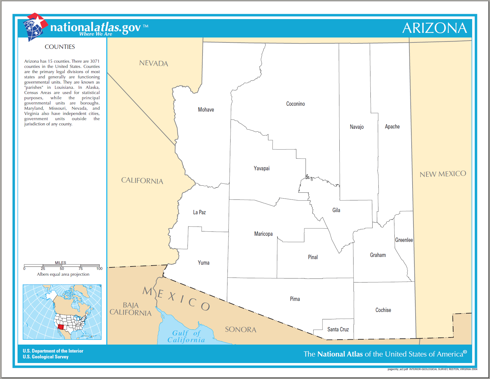
| 05:28, 3 May 2007 | Counties of Arizona NA.png (file) |  |
240 KB | {{Information| |Description=Counties of Arizona |Source=[http://www.nationalatlas.gov National Atlas] }} Category:Maps of Arizona {{PD-USGov-Atlas}} |
| 05:18, 3 May 2007 | Counties of Alabama NA.png (file) |  |
310 KB | |
| 12:39, 17 April 2007 | Map of Russel Cave National Monument.png (file) |  |
130 KB | {{Information |Description=Map of Russel Cave National Monument |Source=National Park Service |Date= |Author=National Park Service |Permission={{PD-USGov-NPS}} |other_versions= }} Category:Russel Cave National Monument |
| 09:00, 18 March 2007 | Berti Vogts hu.jpg (file) |  |
490 KB | {{Bilderwerkstatt}} Modified version of the following picture: ---- Image:Berti Vogts.JPG == Summary == * Bildbeschreibung: Hans-Hubert Vogts * Quelle: selbst fotografiert * Fotograf/Zeichner: User:Florian K * Datum: 6. April 2006 * Sonsti |
| 20:28, 27 September 2006 | Map of Walnut Canyon NM.png (file) |  |
573 KB | {{Information |Description=Map of Walnut Canyon NM |Source=http://www.nps.gov |Date= |Author= |Permission= |other_versions= }} {{PD-USGov-NPS}} category:Walnut Canyon National Monument |
| 17:10, 21 September 2006 | Squaretower07.jpg (file) |  |
591 KB | {{Information |Description=hovenweep castle |Source=http://www.nps.gov |Date= |Author= |Permission= |other_versions= }} {{PD-USGov-NPS}} category:Hovenweep National Monument |
| 17:07, 21 September 2006 | Squaretower05.jpg (file) |  |
810 KB | {{Information |Description=stronghold house |Source=http://www.nps.gov |Date= |Author= |Permission= |other_versions= }} {{PD-USGov-NPS}} category:Hovenweep National Monument |
| 17:02, 21 September 2006 | Squaretower04.jpg (file) |  |
620 KB | {{Information |Description=stronghold house |Source=http://www.nps.gov |Date= |Author= |Permission= |other_versions= }} {{PD-USGov-NPS}} category:Hovenweep National Monument |
| 16:58, 21 September 2006 | Horseshoe01.jpg (file) |  |
517 KB | {{Information |Description=horseshoe group |Source=http://www.nps.gov |Date= |Author= |Permission= |other_versions= }} {{PD-USGov-NPS}} category:Hovenweep National Monument |
| 16:55, 21 September 2006 | Holly01.jpg (file) |  |
588 KB | {{Information |Description=holly group |Source=http://www.nps.gov |Date= |Author= |Permission= |other_versions= }} {{PD-USGov-NPS}} category:Hovenweep National Monument |
| 16:51, 21 September 2006 | Cutthroat02.jpg (file) |  |
534 KB | {{Information |Description=cutthroat 02 |Source=http://www.nps.gov |Date= |Author= |Permission= |other_versions= }} {{PD-USGov-NPS}} category:Hovenweep National Monument |
| 16:47, 21 September 2006 | Cutthroat01.jpg (file) |  |
874 KB | {{Information |Description=cutthroat castle |Source=http://www.nps.gov |Date= |Author= |Permission= |other_versions= }} {{PD-USGov-NPS}} category:Hovenweep National Monument |
| 16:44, 21 September 2006 | Cajon01-1.jpg (file) |  |
644 KB | {{Information |Description=cajon group |Source=http://www.nps.gov |Date= |Author= |Permission= |other_versions= }} {{PD-USGov-NPS}} category:Hovenweep National Monument |
| 08:45, 21 September 2006 | Map of Cabrillo National Monument.png (file) |  |
159 KB | {{Information |Description=Map of Cabrillo National Monument |Source=http://www.nps.gov |Date= |Author= |Permission= |other_versions= }} {{PD-USGov-NPS}} category:Cabrillo National Monument |
| 06:38, 19 September 2006 | Map of Canyon of the Ancients National Monument.png (file) |  |
3.68 MB | {{Information |Description=Map of Canyon of the Ancients National Monument |Source=http://www.blm.gov |Date= |Author= |Permission= |other_versions= }} {{PD-USGov-BLM}} category:Canyons of the Ancients National Monument |
| 20:53, 18 September 2006 | Map of Guadalupe Mountains National Park.jpg (file) |  |
1.15 MB | {{Information |Description=Map of Guadalupe Mountains National Park |Source=http://www.nps.gov |Date= |Author= |Permission= |other_versions= }} {{PD-USGov-NPS}} category:Guadalupe Mountains National Park |
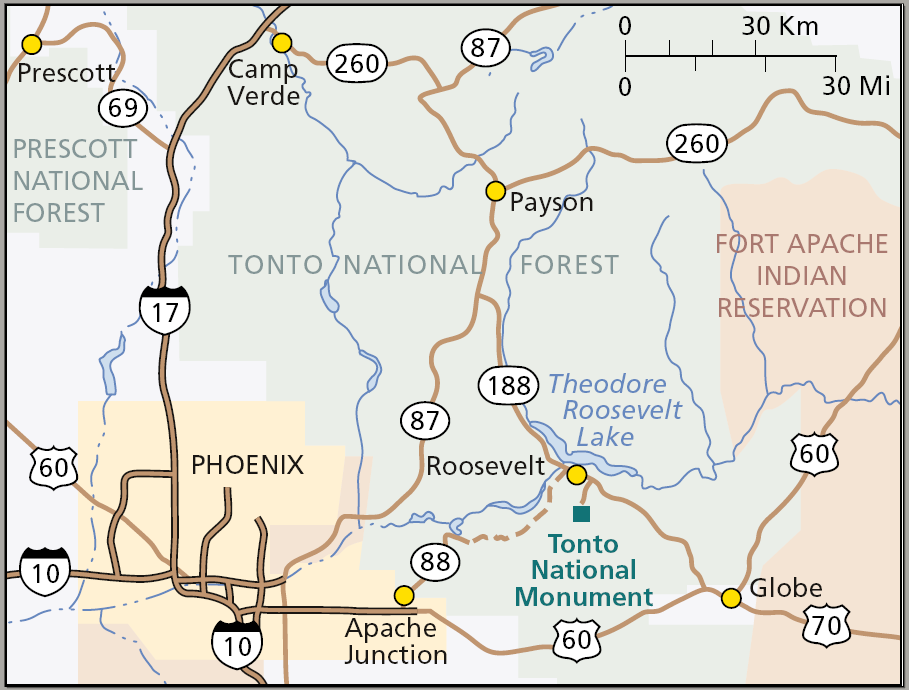
| 09:05, 18 September 2006 | Map of Tonto National Monument.png (file) |  |
168 KB | {{Information |Description=Map of Tonto National Monument |Source=http://www.nps.gov |Date= |Author= |Permission= |other_versions= }} {{PD-USGov-NPS}} category:Tonto National Monument |
| 18:53, 13 September 2006 | Ironwd2.jpg (file) |  |
13 KB | {{Information |Description=Ironwood Forest National Monument |Source=Buereau of Landmanagement |Date= |Author= |Permission= |other_versions= }} {{PD-USGov-BLM}} category:Ironwood Forest National Monument |
| 18:49, 13 September 2006 | Map of Ironwood Forest National Monument.png (file) |  |
436 KB | {{Information |Description=Map of Ironwood Forest National Monument |Source=Buereau of Landmanagement |Date= |Author= |Permission= |other_versions= }} {{PD-USGov-BLM}} category:Ironwood Forest National Monument |
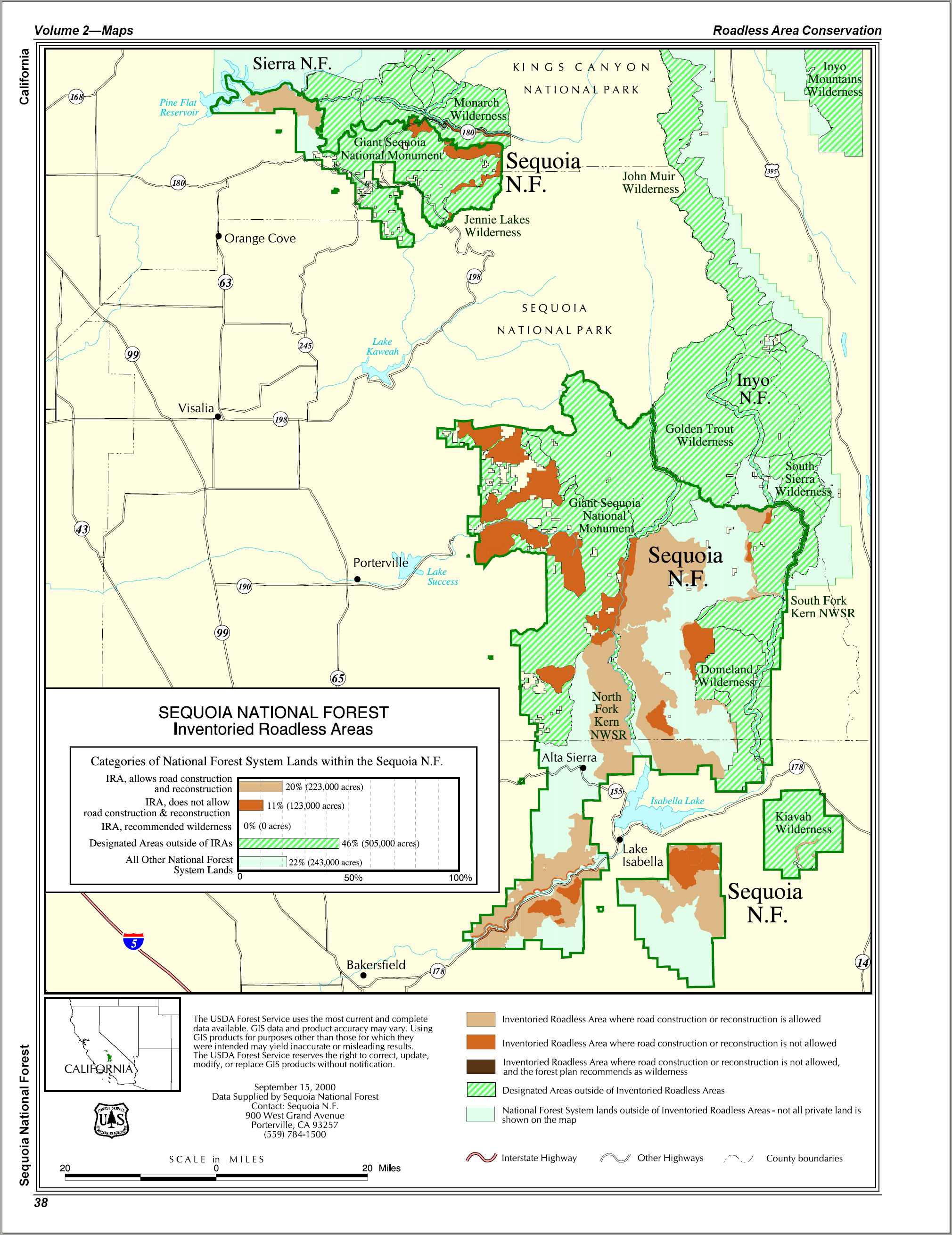
| 07:50, 13 September 2006 | Map of Giant Sequoia NM.png (file) |  |
987 KB | {{Information |Description=Map of Giant Sequoia NM |Source=http://www.fs.fed.us/ |Date= |Author= |Permission= |other_versions= }} {{PD-USGov-USDA}} Category:Giant Sequoia National Monument |
| 13:43, 12 September 2006 | Map of Bents old Fort NHS.png (file) |  |
104 KB | {{Information |Description=Map of Bent's Old Fort NHS |Source=http://www.nps.gov |Date= |Author= |Permission= |other_versions= }} {{PD-USGov-NPS}} Category:Bent's Old Fort National Historic Site |
| 13:42, 12 September 2006 | Strategic location of Bents Fort.png (file) |  |
519 KB | {{Information |Description=Location of Bent's Old Fort NHS |Source=http://www.nps.gov |Date= |Author= |Permission= |other_versions= }} {{PD-USGov-NPS}} Category:Bent's Old Fort National Historic Site |
| 19:35, 10 September 2006 | Map of Arches National Park.png (file) |  |
1.2 MB | {{Information |Description=Map of Arches National Park |Source=http://www.npw.gov |Date= |Author= |Permission= |other_versions= }} {{PD-USGov-NPS}} category:Arches National Park |
| 17:39, 10 September 2006 | Map of Fort Matanzas National Monument.png (file) |  |
147 KB | {{Information |Description=Map of Fort Mantanzas National Monument, Florida |Source=http://www.nps.gov |Date= |Author= |Permission= |other_versions= }} {{PD-USGov-NPS}} category:Fort Matanzas National Monument |
| 17:33, 10 September 2006 | Fortwestern.jpg (file) |  |
59 KB | {{Information |Description=Fort Mantanzas, Florida |Source=http://www.nps.gov |Date= |Author= |Permission= |other_versions= }} {{PD-USGov-NPS}} category:Fort Matanzas National Monument |
| 13:50, 5 September 2006 | Map of USA SD.svg (file) |  |
167 KB | {{Information| |Description=Map of USA with South Dakota highlighted |other_versions=image:Map of USA with state names.svg }} Category:Maps of the United States Category:Maps of South Dakota Category:SVG maps {{GFDL-en}}{{cc-by-2.0}}{{c |
| 10:49, 4 September 2006 | Map of White Sands National Monument.png (file) |  |
349 KB | {{Information |Description=Map of White Sands National Monument |Source=http://www.nps.gov |Date= |Author= |Permission= |other_versions= }} Category:White Sands National Monument {{PD-USGov-NPS}} |
| 08:10, 29 August 2006 | Map of North Cascades National Park.png (file) |  |
1.06 MB | {{Information |Description=Map of North Cascades National Park |Source=http://www.nps.gov |Date= |Author= |Permission= |other_versions= }} {{PD-USGov-NPS}} category:North Cascades National Park |
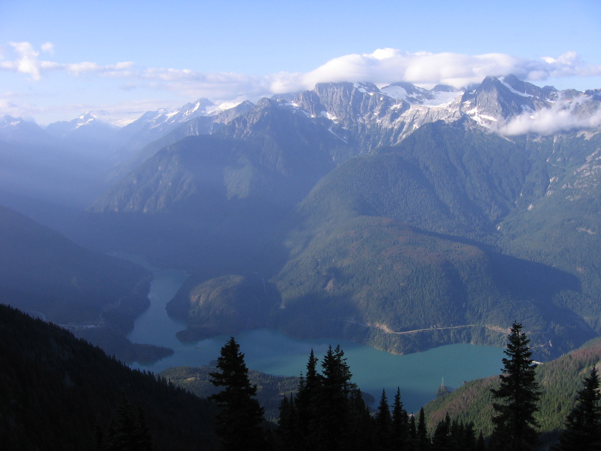
| 07:54, 29 August 2006 | Ross Lake morning.jpg (file) |  |
565 KB | {{Information |Description=Ross Lake in North Cascades National Park |Source=http://en.wikipedia.org/wiki/Image:Ross_Lake_morning.jpg |Date= |Author=Matt Ashman took this picture from Sourdough Mountain, August 2005 |Permission=This image is copyrighted. |
| 20:16, 28 August 2006 | Precipitation of Kentucky.png (file) |  |
479 KB | {{Information| |Description=Precipitation of Kentucky |Source=[http://www.nationalatlas.gov National Atlas] }} Category:Maps of the United States Category:Maps of Kentucky {{PD-USGov-Atlas}} |
| 19:34, 28 August 2006 | Map of Glacier National Park.png (file) |  |
5.04 MB | {{Information |Description=Map of Glacier National Park |Source=http://www.nps.gov |Date= |Author= |Permission= |other_versions= }} {{PD-USGov-NPS}} category:Glacier National Park |
| 20:49, 27 August 2006 | Map of Great Smoky Mountains National Park.png (file) |  |
3.37 MB | {{Information |Description=Map of Great Smoky Mountains National Park |Source=http://www.nps.gov |Date= |Author= |Permission= |other_versions= }} {{PD-USGov-NPS}} category:Great-Smoky-Mountains-Nationalpark |
| 16:30, 27 August 2006 | Joshua Park.JPG (file) |  |
2.37 MB | {{Information |Description=Joshue Tree National Park |Source=http://en.wikipedia.org/wiki/Image:Joshua_Park.JPG |Date= |Author={{author:en:BorisFromStockdale|PD}} |Permission= |other_versions= }} category:Joshue Tree National Park |
| 12:34, 27 August 2006 | Map of Isle Royale National Park.png (file) |  |
1.1 MB | {{Information |Description=Map ofIsle Royale National Park |Source=http://www.nps.gov |Date= |Author= |Permission= |other_versions= }} {{PD-USGov-NPS}} category:Isle Royale National Park |
| 12:30, 27 August 2006 | The Edisen Fishery - Isle Royale National Park, Michigan.jpg (file) |  |
1.45 MB | {{Information |Description=Isle Royal National Park |Source=http://www.nps.gov/pub_aff/imagebase.html |Date= |Author= |Permission= |other_versions= }} {{PD-USGov-NPS}} category:Isle Royal National Park |
| 16:22, 26 August 2006 | WICA2348.jpg (file) |  |
719 KB | |
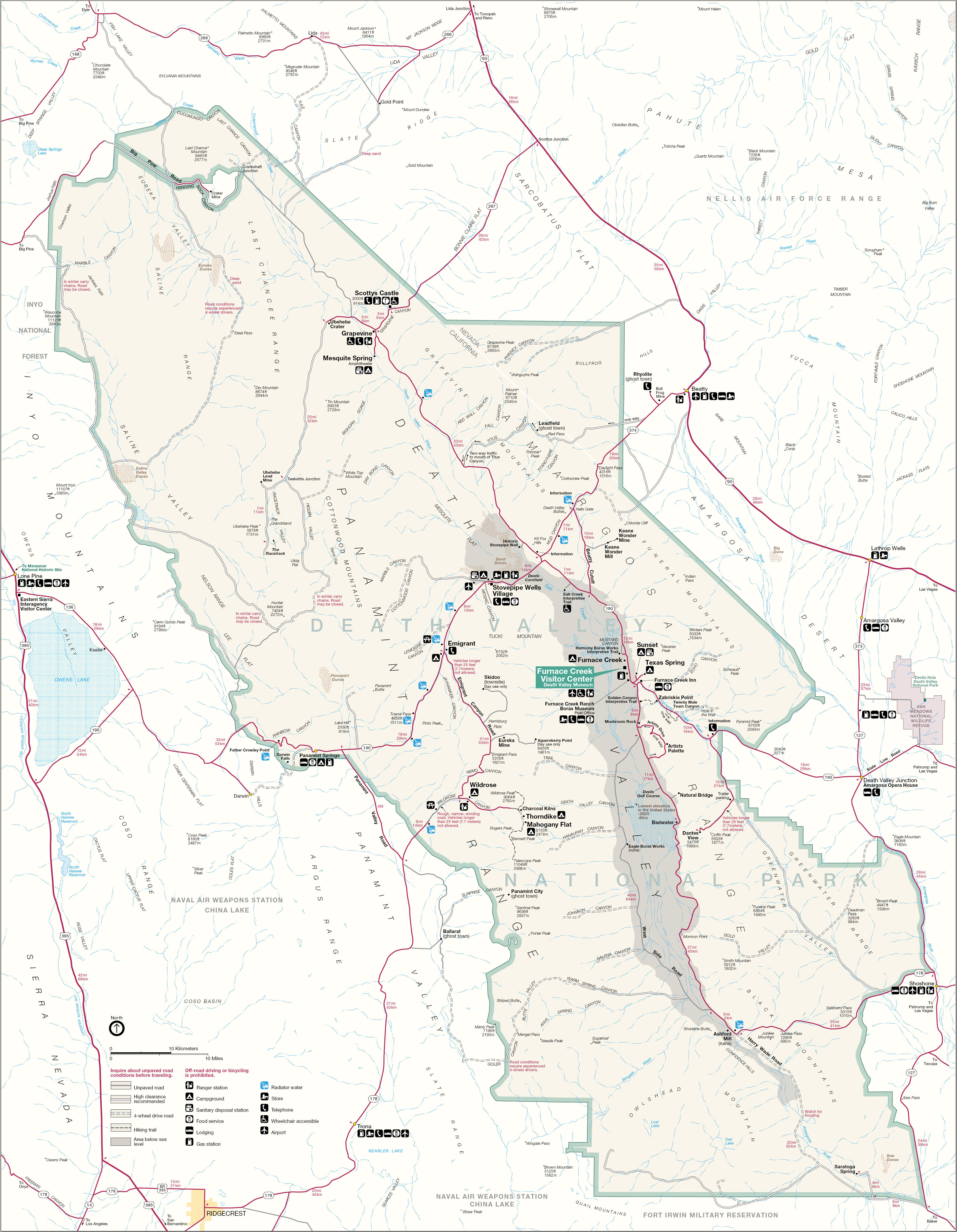
| 05:05, 25 August 2006 | Map of Death Valley National Park.jpg (file) |  |
2.76 MB | {{Information |Description=Death Valley National Park |Source=http://www.nps.gov |Date= |Author= |Permission= |other_versions= }} {{PD-USGov-NPS}} category:Death Valley National Park |
| 18:08, 24 August 2006 | Map of Capitol Reef National Park.png (file) |  |
2.54 MB | {{Information |Description=Map of Capitol Reef National Park |Source=http://www.nps.gov |Date= |Author= |Permission= |other_versions= }} {{PD-USGov-NPS}} category:Capitol Reef National Park |
| 17:45, 24 August 2006 | Map of Black Canyon of the Gunnison National Park.png (file) |  |
1.8 MB | {{Information |Description=Map of Black Canyon of the Gunnison National Park |Source=http://www.nps.gov |Date= |Author= |Permission= |other_versions= }} {{PD-USGov-NPS}} [[category:Black Canyon of the Gunnison National Park]9 |
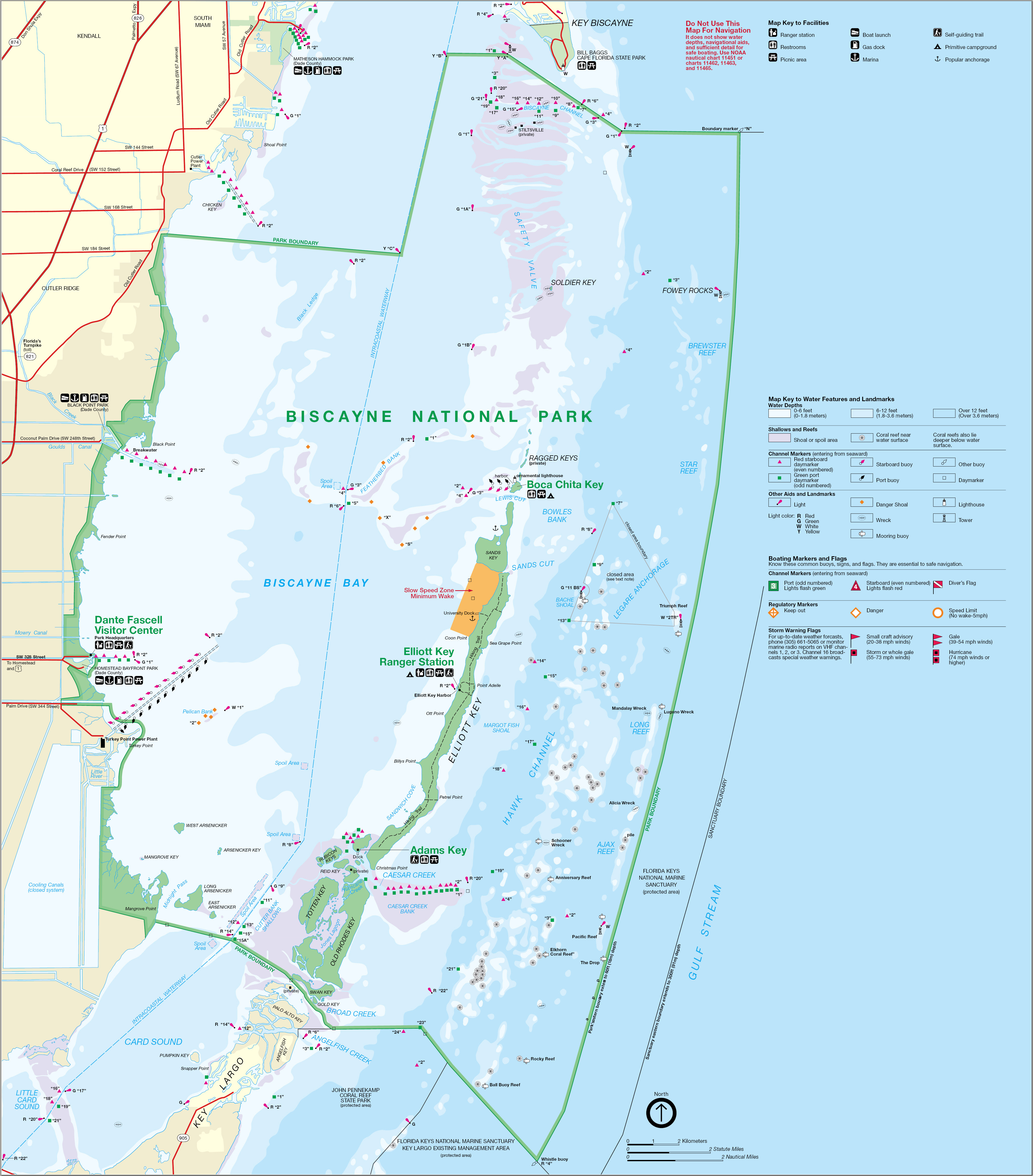
| 17:11, 24 August 2006 | Map of Biscayne National Park.jpg (file) |  |
2.34 MB | {{Information |Description=Map of Biscayne National Park |Source=http://www.nps.gov |Date= |Author= |Permission= |other_versions= }} {{PD-USGov-NPS}} category:Biscayne National Park |
| 11:04, 20 August 2006 | John-muir2.jpg (file) |  |
29 KB | {{Information |Description=John Muir NM |Source=http://www.nps.gov |Date= |Author= |Permission= |other_versions= }} {{PD-USGov-NPS}} Category:Golden Gate National Recreation Area |
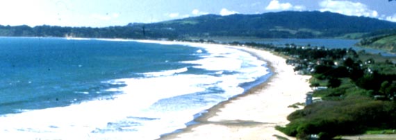
| 11:03, 20 August 2006 | Stbe2.jpg (file) |  |
20 KB | {{Information |Description=Stinson Beach |Source=http://www.nps.gov |Date= |Author= |Permission= |other_versions= }} {{PD-USGov-NPS}} Category:Golden Gate National Recreation Area |
| 11:02, 20 August 2006 | Pobo-bt.jpg (file) |  |
23 KB | {{Information |Description=Point Bonita Lighthouse |Source=http://www.nps.gov |Date= |Author= |Permission= |other_versions= }} {{PD-USGov-NPS}} Category:Golden Gate National Recreation Area |
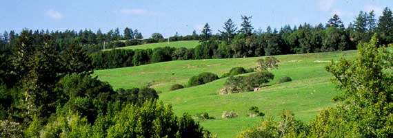
| 11:01, 20 August 2006 | Olema.jpg (file) |  |
24 KB | {{Information |Description=Olema Valley |Source=http://www.nps.gov |Date= |Author= |Permission= |other_versions= }} {{PD-USGov-NPS}} Category:Golden Gate National Recreation Area |
| 11:00, 20 August 2006 | Marin Headlands2.jpg (file) |  |
26 KB | {{Information |Description=Marin Headlands |Source=http://www.nps.gov |Date= |Author= |Permission= |other_versions= }} {{PD-USGov-NPS}} Category:Golden Gate National Recreation Area |
| 10:59, 20 August 2006 | Marin Headlands.jpg (file) |  |
91 KB | Auf eine alte Version zurückgesetzt |
| 10:56, 20 August 2006 | Fort Baker.jpg (file) |  |
28 KB | {{Information |Description=Fort Baker |Source=http://www.nps.gov |Date= |Author= |Permission= |other_versions= }} {{PD-USGov-NPS}} Category:Golden Gate National Recreation Area |
| 07:18, 20 August 2006 | Map of Wrangell-St. Elias National Park.jpg (file) |  |
3.25 MB | {{Information |Description=Map of Wrangell-St. Elias National Park |Source=http:/www.nps.gov |Date= |Author= |Permission= |other_versions= }} {{PD-USGov-NPS}} Category:Wrangell-St. Elias National Park |