Size of this JPG preview of this DJVU file: 366 × 599 pixels. Other resolutions: 146 × 240 pixels | 293 × 480 pixels | 469 × 768 pixels | 625 × 1,024 pixels | 1,250 × 2,048 pixels | 3,689 × 6,042 pixels.
Original file (3,689 × 6,042 pixels, file size: 4.19 MB, MIME type: image/vnd.djvu)
| This is a file from the Wikimedia Commons. Information from its description page there is shown below. Commons is a freely licensed media file repository. You can help. |
| Description |
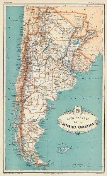
Español: Mapa general de la Republica Argentina. Paz Soldan. Atlas geografico Argentino. Grabado por Erhard hermanos, 8 Calle Nicole, Paris. Imp. Erhard hermanos. Felix Lajouane, Editor, Buenos-Aires, 1888. Edicion corregida y aumentada |
||||
| Date | |||||
| Source | http://www.davidrumsey.com/luna/servlet/detail/RUMSEY~8~1~20635~570012:Mapa-general-de-la-Republica-Argent | ||||
| Author | Mariano Felipe Paz Soldán | ||||
| Permission (Reusing this file) |
|
||||
| Other versions | "Mapa Canal del Beagle, 1888.jpg" | ||||
Esta edicion hace pasar la frontera por el norte de las islas Picton, Nueva y Lennox
File history
Click on a date/time to view the file as it appeared at that time.
| Date/Time | Thumbnail | Dimensions | User | Kommentar | |
|---|---|---|---|---|---|
| current | 22:41, 15 September 2008 |  | 3,689 × 6,042 (4.19 MB) | Keysanger | {{Information |Description={{es|1=Mapa general de la Republica Argentina. Paz Soldan. Atlas geografico Argentino. Grabado por Erhard hermanos, 8 Calle Nicole, Paris. Imp. Erhard hermanos. Felix Lajouane, Editor, Buenos-Aires, 1888. Edicion corregida y aum |
File usage
No pages on the English Wikipedia use this file (pages on other projects are not listed).