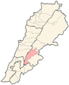
Lala, Lebanon
Appearance
Lala, Lebanon
لالا | |
|---|---|
Village | |
| Coordinates: 33°36′01″N 35°45′44″E / 33.60028°N 35.76222°E | |
| Country | Lebanon |
| Governorate | Beqaa Governorate |
| District | Western Beqaa |
| Elevation | 3,670 ft (1,120 m) |
| Time zone | UTC+2 (EET) |
| • Summer (DST) | +3 |
Lala (Arabic: لالا), is a village located in the Western Beqaa District of the Beqaa Governorate in Lebanon.
History
[edit]In 1838, Eli Smith noted it as Lala; a Sunni Muslim village in the Beqaa Valley.[1]
In the early 1990s, the 2,500 residents of Lala relied on the village's 7,500 emigrants living abroad for 70% of their income.[2]
References
[edit]- ^ Robinson and Smith, 1841, vol 3, 2nd appendix, p. 141
- ^ Arsan, Andrew (2018). Lebanon: a country in fragments (First published in the United Kingdom ed.). London: Hurst & Company. p. 224. ISBN 978-1-84904-700-5.
Bibliography
[edit]External links
[edit]- Lala, localiban


