
FLINT, Mich. (WJRT) - Wednesday and Thursday morning are First Alert Weather Days (FAWD). The FAWD will expire after our Noon newscast Thursday because conditions will slowly improve thereafter.
Rain will once again get heavier into the evening and overnight hours for many of us. Expect bands to lift on through over the next several hours and last into Thursday for many. Localized flooding is still possible in addition to high winds causing minor tree damage and power outages.
Temperatures will hover in the lower 50s and winds will increase overnight as well. At times some gusts could push the 60 mph threshold on the Lake Huron shoreline. Those further inland can expect gusts of 40-50mph.
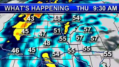
Thursday rain will be heaviest early in the day with scattered lighter showers into the afternoon. Winds will slowly die for many, and even become calm into our Thumb Counties. That’s where the center of the storm will be with the lightest winds. On the backside of the storm near Mount Pleasant, it could still be quite windy into the afternoon. Think of it like the eye of a hurricane.
Friday some showers are possible to the north in the morning before we clear out with highs near 70.
Copyright 2021 WJRT. All rights reserved.