July 14, 2024

Another round of dangerous heat arrives during a dangerously hot summer


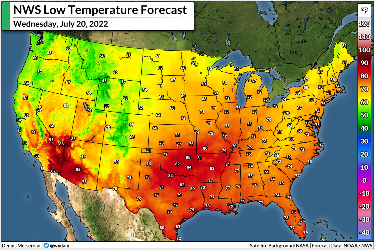
An excessively hot summer across the U.S. rolls on this week as another stretch of dangerously hot temperatures spreads from I-5 to I-95.

Temperatures could easily crest the century mark for many locations over the next couple of days as broad ridges of high pressure rule the roost to start the week.

Tuesday will feature the worst temperatures, with 100-degree readings expected in Oklahoma City, Nashville, Washington, and Philadelphia. The high heat will stretch all the way into New England, where daytime highs in the 90s will reach into Maine.


Humidity will make the heat exceptionally dangerous in many of these locations, with heat indices exceeding 105 for many communities. 

The National Weather Service's new HeatRisk product shows widespread "major" to "extreme" impacts from this latest bout of high heat.


Folks living with chronic health conditions, working outside, or living without air conditioning will feel the greatest impacts from this latest heat wave. Heat exhaustion or heat stroke can develop in under an hour with these conditions.

Very warm and humid nights won't provide much relief from the blazing daytime temperatures. The compounding effects of hot days and steamy nights will make this especially tough for folks without adequate cooling at home. Fans alone won't be enough to combat this heat.

This is the latest volley of blistering temperatures during an already-hot summer across almost all of the United States.

Source: IEM

Data collected by the Iowa Environmental Mesonet shows that just about everyone save for the northern Plains and Upper Midwest has dealt with above-average temperatures so far this season. Much of the excessive heat has been driven by warmer-than-normal nighttime low temperatures, a side effect of the increased humidity we've seen this season.

Source: IEM

Folks across the Southwest have taken the brunt of the extreme heat this year, with week after week of brutally hot temperatures roasting the region. Phoenix has seen above-average temperatures on 163 of the 195 days we've trudged through so far in 2024. The last time they saw a below-average day was at the beginning of May.

Source: IEM

It's not just the Southwest dealing with the heat. It's a similar story back east. Washington, D.C., has seen above-average temperatures for 78 percent of the year through Saturday, July 13, and we're about to add another week of excessive heat to those grim statistics.

The relentless heat we've seen so far this year is exactly what you'd expect to see in a changing climate. Temperatures have steadily risen each decade across just about the entire United States—and we're even outpacing the new climate standards that run from 1991 to 2020. 

Source: Climate Central

Climate change sets a new baseline for extreme heat throughout the United States and around the world. As the entire frame of reference moves toward a hotter climate, warm temperature extremes are far more likely that cold temperature extremes. Excessive heat will come in hotter than what we grew used to just one or two generations ago.


Follow me on Facebook | Bluesky | Threads | Instagram | Twitter

Get in touch! Send me an email.

Please consider subscribing to my Patreon. Your support helps me write engaging, hype-free weather coverage—no fretting over ad revenue, no chasing viral clicks. Just the weather.


June 17, 2024

Extreme heat kills. It's no joke. Folks shouldn't treat it like one.


If a tornado outbreak killed a few hundred people, it would be remembered as a national tragedy. 

When a heat wave kills a few hundred people, it's the butt of countless jokes. 

People are wimps. Just turn on a fan.

Get used to it like we are down here. It's just called summer.

That kind of nonsense shows up every time there's a prolonged extreme heat event and it's never any less enraging.

Extreme heat is one of the deadliest weather events in the world.

It's not a made-for-television disaster, but it's there whether we see it or not—silently claiming parents and grandparents, striking down perfectly healthy kids at football games, exacting a horrible toll on lower income people already struggling to make ends meet.


Heat waves are responsible for nearly half of all disaster-related fatalities. Heat has claimed an average of 188 lives per year over the past decade, compared to 103 flood-related deaths and 48 tornado-related fatalities over the same period.

Hot temperatures are relative. A 90°F day with humidity requires a level of acclimatization to handle. Someone living in Orlando, Florida, will have an easier time slogging through a scorching day than someone up in Burlington, Vermont. But not even everyone in the south has access to air conditioning. Extreme heat still kills and injures vulnerable people in the humid southeast and the deserts of the southwest.


It's not just a matter of what you're used to.

Lots of homes in the northern United States and throughout Canada still don't have air conditioning—whether by design or simply for lack of affordability. These homes become unbearably hot when the outside temperature climbs above just 80°F. Throw higher readings and some heat-retaining humidity into the mix and you have a recipe for extreme physical stress just trying to exist.

Heat waves also compound on themselves. Humid heat doesn't allow for any relief at night. Hot days spilling into hot nights wrap around you like a wet blanket when you don't have air conditioning to stay cool. Fans don't help in that kind of setup.

You're left with a situation where hundreds of thousands of vulnerable neighbors, friends, and family members are left to their own devices, hoping they see relief at the end of a days-long nightmare. They're lucky if they can get to a cooling center or visit someone for some relief from the stifling air. Many of them are forced to grin and bear the suffering, hoping that they're able to stay hydrated enough to stave off heat exhaustion or heat stroke.

Extreme heat is no joke.


Follow me on Facebook | Bluesky | Threads | Instagram | Twitter

Get in touch! Send me an email.

Please consider subscribing to my Patreon. Your support helps me write engaging, hype-free weather coverage—no fretting over ad revenue, no chasing viral clicks. Just the weather.


June 17, 2023

Dangerous heat, dangerous storms continue as bizarre pattern persists


Dangerous weather will continue rolling through the weekend and into next week as a freaky pattern for the middle of June stubbornly holds out over the southern United States.

Additional rounds of powerful storms will persist over the next couple of days, alongside an unseasonable slug of unbearable heat parked over Texas.

Day after day of severe thunderstorms have put tremendous stress on the southern states this past week. We've had deadly tornadoes, tremendous amounts of destructive hail, flash flood emergencies, and widespread wind damage as one wave of destructive storms after another swept from the southern Plains to the northern Gulf Coast.

SOURCE: Twister Data

All of the hubbub is the result of a subtropical jet stream locked over the region, the result of a very strong upper-level ridge of high pressure standing tall over Mexico.

Beneath the ridge, extremely hot and humid temperatures have bathed much of Mexico and Texas in recent days, with daytime highs easily exceeding 100°F and heat indices climbing to 110-115+ during the day.

This heat will continue into next week, with highs in the 100s a common sight across much of southern and southeastern Texas into the middle of next week. It's not bad enough that the days are so incredibly hot—it's that the extreme humidity is preventing nights from providing any relief at all. 


Dew points in the upper 70s are preventing nighttime lows from dipping much below 77-80°F.

Heat waves like this are compounding disasters. Folks without access to air conditioning rely on nights for some relief from the unbearable heat.

One or two days is survivable, but when you get into 5+ days of stifling days and putrid nights, it will start to take a significant physical toll on vulnerable individuals. 


The outer edge of that heat dome parked over Texas is serving as the focus for all of those rowdy thunderstorms we've seen all week. We typically don't see such a dynamic setup in the south this late in the year. The combination of summertime temperatures with a springtime severe weather setup has resulted in violent thunderstorms, an adjective that seems like it's an understatement.

Extreme instability has fueled raucous thunderstorms that are able to organize and intensify thanks to that unusual wind shear present over the region.


During more normal times, these storms would just be those typical summertime drenchers that pop up during the day and fizzle out around sunset. That wind shear has allowed these storms to structure themselves into hail-churning wind machines, with golfball size hail and 70+ mph wind gusts a common sight.

The Storm Prediction Center highlights additional risks for severe weather on Saturday, Sunday, and Monday, covering the exact same areas battered by relentless storms since early this past week.

We'll finally start to catch a break on all fronts by the middle of the week, thankfully, as the pattern breaks and allows that ridge to weaken. This long-deserved progression in the upper levels of the atmosphere will allow the heat to subside to a more seasonable muck over Texas, while defusing the turbocharged environment that's allowed terrible storms to flourish.

[Top Image: A water vapor image of the U.S. on June 17, 2023, highlighting the ridge over the south responsible for all the nonsense of late, via NOAA.]


You can follow me on Facebook, Mastodon, Twitter, Instagram, or send me an email.

Please consider subscribing to my Patreon. Your support helps me write engaging, hype-free weather coverage—no fretting over ad revenue, no chasing viral clicks. Just the weather.


July 16, 2022

Dangerous Heat, 110°F+ High Temperatures On The Way For Southern Plains


There's a hot summer day and a dang hot summer day. A spell of extreme heat on the southern Plains is set to get worse over the next couple of days as high temperature crank well above the 100-degree mark for much of the region. Highs will easily climb above 110°F for some areas, especially in Oklahoma.

A strong ridge of high pressure building over the western two-thirds of the United States will focus its ire on the southern Plains as we begin the workweek. It's already been pretty darn hot month across the region so far. 12 of the past 16 days at Dallas-Fort Worth Int'l Airport have clocked in at 100°F or hotter so far this month, and that pattern looks to continue as we head into the new week.

The worst of the heat will build on Monday, Tuesday, and Wednesday. The National Weather Service's latest forecast calls for high temperatures to exceed 105°F 

Here are the NWS's predicted highs for Monday, July 18th...


...Tuesday, July 19th...


...and Wednesday, July 20th.


That's brutal heat for anyone. It's going to be exceptionally rough on vulnerable populations such as the elderly, low-income families who don't have adequate (or any) access to air conditioning or fans, folks battling illnesses, and those who have to work outside for long periods of time.


What's going to make the heat even harder is that it's not going to cool off much at night. Tuesday is going to be the hottest day across the region, and nighttime temperatures are going to struggle to fall below 80°F in spots, especially in Oklahoma.

Here's the National Weather Service's predicted low temperatures for Wednesday morning:


That's a morning low of 86°F in Tulsa. Ouch.

Extreme heat is a compounding risk. Each day of excessively hot temperatures bleeds into the next, without much relief at night, adding stress to vulnerable populations until it becomes too much to bear.

Heat exhaustion is no joke. It can sneak up on you in a hurry if you're not careful. Drink more water than you think you need to drink. Don't push it in the hot sunshine. Find ways to stay cool if you don't have adequate cooling. Check on your neighbors if you know they might have a hard time with the heat.

SOURCE: CDC

The ridge will start to break down a bit as we head later into the week, but broad ridging over the central United States will keep temperatures at or above the century mark for the southern Plains at least through next weekend. This is going to be a rough stretch of hot weather the likes of which this region hasn't seen in a long while. 


You can follow me on Twitter or send me an email.

Please consider subscribing to my Patreon. Your support helps me write engaging, hype-free weather coverage—no fretting over ad revenue, no chasing viral clicks. Just the weather.


June 14, 2022

Heat Index Is Real, People Didn't Survive Before A/C, And Other Heat Wave FAQs, Answered


Q: How long is it going to stay hot?

A: As you can tell by the dramatic top image of a thermometer in the sunshine, a mainstay of lazy hot weather coverage, this heat wave isn't going anywhere.

Some of us might get a brief break this weekend, but the heat is going to build back even hotter next week. 100s are possible into the Mid-Atlantic.

Source: Tropical Tidbits

An upper-level low will swing across Ontario and Quebec later this week, sending a surge of (relatively) cooler air sinking down over the eastern United States. It'll be comfortable in the Northeast, but temperatures will only fall down into the upper 80s and low 90s in the southeastern states.

Meanwhile, a newer, stronger ridge will build in behind that upper-level low, allowing high temperatures in the 100s to spill into the northern Plains and Upper Midwest. That ridge will spread east through the weekend, reaching the eastern states by Sunday and Monday with round two of this prolonged heat event.


The heat index is going to make those brutal temperatures feel even hotter. The prolonged nature of this heat event is really dangerous for vulnerable communities. 

Q: The heat index is a ratings ploy to make it sound hotter than it really is!

A: The heat index is real. Your body cools off through evaporative cooling. Sweat evaporating from your skin helps to regular your body temperature when it's hot outside. Humidity interferes with this process.

When it's both hot and humid outside, your body has to struggle to maintain a healthy body temperature. If the dew point is 72°F—which is Florida-esque tropical mugginess—and the air temperature is 95°F, the heat index is 104°F, meaning that your body is feeling the same strain on that muggy 95°F day as it would if it were actually 104°F.

The higher the heat index, the more stress your body endures in the heat. It's a real thing despite what some hipster hot-take havers want to argue otherwise. Test it at your own peril.


Q: Just open the windows and you'll be fine.

A: Opening the windows and switching on fans can help with air circulation, but it all comes back to your body's struggle to cool off when it's both hot and humid.

Keeping the windows open and fans going doesn't actually lower the temperature. It feels cooler because it speeds up the evaporation of your sweat—a process that's disrupted by muggy temperatures.

The true danger is that a heat wave's effects compound with each day of excessive temperatures and humidity. Homes don't have a chance to cool down as one sweltering day bleeds into a stifling night. The stress grows on vulnerable populations with each day of a heat wave, regardless of whether you've got the windows open and a fan cranking.

Q: This is no big deal. People survived before air conditioning! Why are we so weak today?

A: It's called survivorship bias. Lots and lots of people died before air conditioning as a direct result of not having air conditioning.

It's sort of like the folks who scream "why do we need to coddle kids with all these safety features, I grew up just fine!" Sure, you may have turned out okay! But cemeteries are too full of too many little kids who, it turns out, couldn't get by without car seats or vaccines or wall-fastened dressers or unleaded paint on the windowsill. 

Even with air conditioning all over the place today, heat is still the leading weather-related cause of death in the United States. One bad heat wave can kill hundreds of people, a higher toll than years and years of tragic tornadoes combined. Last year's awful heat wave in the Pacific Northwest was Washington's deadliest weather disaster on record, and it killed nearly 600 people up in British Columbia.

Lots of people died before air conditioning. Lots of people still die without air conditioning. Consider yourself fortunate if you don't have to worry about that.


Q: Dry heat is better than a humid heat.

A: If the humidity makes your body work harder, wouldn't that mean a dry heat is better for you than a humid heat? Not necessarily.

An actual air temperature of 110°F with very little humidity in the air still makes your body work very hard to cool itself off. In fact, you can sweat too efficiently in a dry heat, potentially leading to faster dehydration and heat-related illnesses. 

Q: Why is every piece of hot weather advice so condescending?

A: Television meteorologists and online weather blatherers like me are very aware of how condescending it sounds to say "drink water and stay in the shade" to an audience that's almost entirely grown adults.

It's really, really easy to accidentally overdo it. I walk 5 miles every morning. I get cranky if I have to use the treadmill. But, even doing what I do, I have to consciously remember that the hot weather will knock me flat if I push it too hard. "I'm fine," right up until I'm half a mile from home with an empty water bottle and growing leg cramps.

Hearing safety advice over and over is annoying, but it works. It's worth if it one construction site calls it a day to keep its workers from getting sick, or if the sweet old lady down the street decides to do her power walk on the treadmill instead of pushing it in the hot sun.

Q: I'm not thirsty, so I don't need water.

A: Dehydration sneaks up on you. It's one of those things that's better to stave off than try to correct once it's taking a toll you.

Q: I'm healthy. I'm built for the heat. What's the big deal?

A: While the elderly, folks who suffer from medical issues, outdoor workers, and children are the most vulnerable to heat-related illnesses, it can happen to anyone.

Heat is the deadliest form of extreme weather and it's a silent killer to boot. To put it bluntly: someone dying alone in their sweltering apartment doesn't make as good of a headline as someone dying in a tornado, so it doesn't get much attention. 

Q: When will it cool off?

A: Probably in the fall.

Q: This article format is annoying. What gives?

A: It's a riff on this post from 2016. Meh. It's hard to be funny about a heat wave. It's strange—people lose their minds over a snowstorm like the world is ending, but they'll downplay the extreme dangers of heat even though it claims a toll many magnitudes higher than even the worst blizzard. Go figure.


You can follow me on Twitter or send me an email.

Please consider subscribing to my Patreon. Your support helps me write engaging, hype-free weather coverage—no fretting over ad revenue, no chasing viral clicks. Just the weather.


June 8, 2022

Prolonged June Heat Wave Set To Slide East Across The U.S. Next Week


A solid early-season heat wave is roasting towns from California to Texas this week, with a string of daytime temperatures easily climbing above 100°F for many areas. This pattern will slide east heading into next week, bringing a prolonged period of very hot weather to the rest of the southern states.

This week's heat wave is courtesy of a broad upper-level ridge parked over the southwestern corner of the country. Widespread excessive heat warnings and heat advisories are in effect ahead of temperatures that could soar above 110°F in some spots, including California's Central Valley and the typical heat-prone desert communities.


Phoenix is under an excessive heat warning until Sunday evening. The city can expect daytime highs in the low 110s with nighttime lows hovering in the mid-80s. It's a dry heat, we love to say, but raw air temperatures that hot—paired with day after day of nighttime temperatures offering little relief—can easily take a toll on even the healthiest individual. 

It's not as drawn-out of an ordeal over in California, but the heat will make for a couple of rough afternoons over the next few days. The most impactful heat will crank over the Central Valley on Friday afternoon, with a predicted high of 105°F in Sacramento, 104°F in Modesto, and an even 100°F up in Redding. 


The pattern leading to this heat ridge over the southwestern states will break by this weekend as a trough dips southeastward over the Pacific Northwest. That trough will kick the ridge east, setting up a prolonged heat event for the rest of the southern U.S. 

Heading into next week, widespread daytime highs in the mid- to upper-90s look likely from Texas to the Carolinas, with multiple days of 100s on tap for parts of Texas. We could even see temperatures approach the triple-digit mark as far east as the Carolinas. 


Humidity makes the heat even worse. It's not just a cliché—the extra moisture in the air makes it harder for sweat to evaporate from your skin, preventing you from cooling off efficiently. This can quickly lead to heat exhaustion or heat stroke if you're not careful.

Heat kills more people in the U.S. every year than any other type of extreme weather. Prolonged heat is especially deadly because of the stress exacted by days of extremely hot afternoons followed by sultry nights that offer no relief.

Source: CDC

The compounding effect of one hot day bleeding into the next exacts a terrible toll on vulnerable populations, such as low-income households without air conditions, the elderly, and those who are homeless or work long hours outdoors.

Most hot weather safety advice sounds condescending, but it's very easy for even a fit and perfectly healthy person to overdo it in hot weather and quickly grow ill because of overexertion. Drink more water than you think you need. Put off the chores and workouts until very early in the morning or late in the evening. The lawn will forgive you if you wait a week to mow it, and using a treadmill is better than passing out on a busy street.


You can follow me on Twitter or send me an email.

Please consider subscribing to my Patreon. Your support helps me write engaging, hype-free weather coverage—no fretting over ad revenue, no chasing viral clicks. Just the weather.


August 9, 2021

Extreme Heat Will Roast The U.S. From Coast To Coast This Week


Summer has no plans on letting up anytime soon. A double-barreled heat wave will set up over the United States this week, bringing another round of searing heat from the Pacific coast to the Atlantic seaboard. Widespread highs in the 100s are likely across the west, while folks back east deal with a dangerous spell of heat and humidity.

The Setup

This is our...what, sixth?...major heat wave so far this summer. The setup is pretty much the same as the others, with the added flair of two ridges instead of just one.
Source: Tropical Tidbits

A strong upper-level ridge will develop over the eastern Pacific at the same time a center of high pressure strengthens over or just off the coast of the southeastern United States.

Ridges aloft foster sinking air. Air dries out and warms up as it descends. The sinking air and bright sunshine can send temperatures soaring, and local wind patterns—related to terrain in the west, and humid southerly winds once you're east of the Rockies—can exacerbate the heat. 

The Context

It's been a rough summer. Dozens of communities in Washington and Oregon broke their all-time heat records with an unprecedented heat wave that roasted the region in late June.


Portland, Oregon's predicted high temperature of 104°F on Thursday would've approached the all-time record high before it fell in late June. The city's previous all-time record high was 107°F until that heat wave broke that record on three consecutive days, topping out at a searing 116°F on June 28th.

We're not going to see temperatures nearly that hot this time around, but it's going to be a dangerous stretch of heat that'll be rough on anyone who lives with health issues or doesn't have reliable access to air conditioning.

There's also the issue of wildfires.

This summer's string of heat waves out west allowed wildfires to flourish long before traditional wildfire season begins. We've witnessed the effects of these fires in just about every corner of the U.S. and Canada over the past couple of months as wildfire smoke choked cities like Denver and New York.

California's ongoing Dixie Fire is now the second-largest wildfire on record in the state. The impending heat wave will lead to another stretch of favorable conditions for wildfires to spark and grow.

The Temperatures

It's tough to rattle off all the cities that are at risk of dangerously high heat and humidity this week. Take a look at these high temperature forecasts from the National Weather Service.

Tuesday, August 10:


Wednesday, August 11:


Thursday, August 12:


Friday, August 13:


Saturday, August 14:


It's a widespread, coast-to-coast affair for everyone except for the highest elevations in the Rockies and some spots in the Upper Midwest that'll feel the effects of an upper-level low traversing the Canadian Prairies.

The Risks

This kind of hot weather is dangerous for vulnerable people and those who don't have access to air conditioning.

Source: CDC

Much of the Pacific Northwest is under an extreme heat warning for the duration of the heat wave. Hundreds (if not thousands) of people died in Washington, Oregon, and British Columbia during the major heat event in late June.

Heat advisories are beginning to paint the U.S. east of the Rockies, as well, as the heat will be accompanied by stifling humidity.

Humidity makes high heat even worse because it precludes our ability to cool off effectively. Our bodies sweat to take advantage of evaporative cooling. Sweat is slow to evaporate when the air is humid, which can cause our bodies to overheat. This can easily lead to life-threatening heat-related illnesses.

If you know any elderly folks who live alone or those who live with health issues that make them vulnerable to the heat, check in on them throughout the heat wave and make sure they're doing okay. If you don't have access to air conditioning, try to go somewhere cool if you can. Limit the amount of time you spend outdoors. Even a healthy, physically fit person can develop heat exhaustion or heat stroke in this kind of weather.


You can follow me on Twitter or send me an email.

Please consider subscribing to my Patreon. Your support helps me write engaging, hype-free weather coverage—no fretting over ad revenue, no chasing viral clicks. Just the weather.
 

July 27, 2021

A Nationwide Heat Wave Leads To A Severe Weather Risk On Wednesday


Hey, hey—it's a story about heat that's not just about the west! Aren't we special? A large ridge of high pressure building over the central United States will intensify the heat most of us are feeling this week. Highs will soar into the 100s in the northern Plains while unbearably humid conditions spread over the central and the southern states. The edge of the ridge could foster a risk for severe thunderstorms in parts of the Midwest and Mid-Atlantic on Wednesday.

The pattern over the U.S. this week is the classic, putrid mess that we have to go through at least once every summer. 

Source: Tropical Tidbits

A big ridge of high pressure parked over the center of the country will send temperatures soaring, which is no small thing given how high humidity levels are right now. Some communities could see a dew point around 80°F, which is near the upper end of how muggy it can feel without actually diving into a boiling pot of spaghetti.

If you're looking for relief, the only spots to find it outside of the mountains will be the Northeast and parts of the Great Lakes, where temperatures will gradually cool off toward this weekend as an upper-level trough settles into the region. 

For everyone else, though, it's going to feel just awful.

Source: CDC

Heat advisories and excessive heat warnings festoon the National Weather Service's alerts map like an art project, warning of temperatures and humidity levels that could quickly lead to heat-related illnesses if you're not careful.

Adults don't need to be told to stay inside and take it easy, of course, but it's really easy to underestimate how much of a toll the heat and humidity take on your body. Even a healthy, physically-fit person can fall victim to heat exhaustion or heat stroke in short order when it's this hot out. 

As with any summertime heat wave, there's a risk for severe storms along and near the outer edge of the ridge responsible for the hot temperatures.


The Storm Prediction Center highlights a risk for severe weather from the Dakotas straight down to the D.C. area, with the greatest risk for severe weather existing over the Upper Midwest.

Overlaying Wednesday's severe weather outlook with Wednesday's high temperature forecast does a great job illustrating how the threat for severe weather follows the edge of the ridge, which appears as a temperature gradient:


This kind of a heat wave is ripe for the formation of a squall line, with a risk for damaging straight-line wind gusts. A squall line that's particularly intense and lasts for a long time can be called a derecho. Don't worry whether or not it'll be a derecho. Just know that there's a risk for severe weather and plan accordingly, charging up your devices and keeping flashlights handy so you can find your way around without draining your phone battery.


You can follow me on Twitter or send me an email.

Please consider subscribing to my Patreon. Your support helps me write engaging, hype-free weather coverage—no fretting over ad revenue, no chasing viral clicks. Just the weather.