August 27, 2024

Yes, 'corn sweat' is real and it can enhance brutal Midwestern humidity


A dangerous heat wave gripping portions of the central United States made headlines this week for two words: corn sweat.

Yes, 'corn sweat' is a real thing that can have a real impact on the weather.

Daytime highs soaring into the middle to upper 90s is brutal any day, but throw in humidity and it's unbearable even for folks who are acclimated to hot temperatures. That's what we're seeing across the Midwest this week. As of about 2:30 p.m. on Tuesday, the temperature at Chicago O'Hare was a record 98°F with a heat index of 114°F. 

That's hot! A major factor driving this excessive heat is the excessive humidity strangling the area like a wet blanket. The best measure of moisture in the air is the dew point, which is a good proxy for how much moisture is present in the air at any given time.


Relative humidity—"the humidity is 95%!"—is really only useful for forecasting fog and wildfires. If you want to measure comfort, dew point is the way to go. 

Any dew point below 50°F is generally dry and comfortable. Things get noticeably humid when the dew point climbs above 60°F. It's downright muggy when the dew point reaches 65°F, and you're in tropical territory when the dew point hits 70°F or higher.

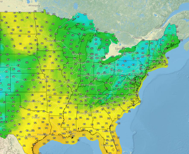
Dew points climbed above 80°F throughout Iowa, Illinois, Minnesota, and Wisconsin during the day Monday. That's an atrocious, strangling level of humidity, especially when combined with high temperatures. 

It's uncommon to see dew points climb toward 80°F outside of tropical rainforests and the U.S. Midwest roughly for the same reason: evapotranspiration, or the infamous "corn sweat."

Plants consume a tremendous amount of water in order to survive and thrive. Excess water evaporates out of the plants into the atmosphere, raising moisture levels to heights rarely seen outside of areas blanketed by lush vegetation.

Why is corn sweat such a big deal and not, say, "kudzu sweat" from those invasive leafy vines that blanket the southern states? Corn gives off a ton of water. "An acre of corn gives off about 3,000-4,000 gallons (11,400-15,100 liters) of water each day," according to the USGS. And we have vast swaths of the Midwest carpeted with cornfields churning out that much water vapor every day.

[Top image courtesy of Unsplash]


Follow me on Facebook | Bluesky | Threads | Instagram | Twitter

Get in touch! Send me an email.

Please consider subscribing to my Patreon. Your support helps me write engaging, hype-free weather coverage—no fretting over ad revenue, no chasing viral clicks. Just the weather.


August 11, 2022

Relief On The Way As Blissful Cold Front Briefly Kicks East Coast Humidity


Ahhh. While there's nothing better than the first cold front of fall, a cold front that scours away the humidity for a few days in the middle of August has to be a close runner up. A push of cooler, drier air working its way down from Canada will sweep over much of the Northeast and Mid-Atlantic through the weekend, bringing a few days of much-deserved gorgeous conditions.

A Sticky Summer So Far

It's been a relentlessly gross summer so far, with hot temperatures every day and sticky humidity to match. Take a look at these daily high dew point values for the past couple of months here in Greensboro, North Carolina.

Data plot generated using this awesome tool from the Iowa Environmental Mesonet.

The dew point is the best way to measure how muggy or dry the air feels. The air is fully saturated (or 100% relative humidity) when the air temperature meets the dew point temperature.

Dew points below 60°F are comfortable. The air starts to feel muggy between 60-65°F, it's noticeably humid above 65°F, and conditions are downright soupy and tropical once the dew point climbs above 70°F.

It's not just a case of "North Carolina being North Carolina in the summer," either. Here's a look at the same chart for Philadelphia, Pennsylvania:

Source: IEM

Yuck. This year's mugginess even stands out compared to other years through the beginning of August. This is a look at how many hours Philadelphia's dew point came in at 60°F or higher between January 1st and August 9th of each year since 1941.

Source: IEM

This summer-to-date ranks as the fourth-muggiest on record in Philadelphia, and the unusually high moisture levels this season is a repeating story up and down the eastern seaboard.

Thankfully, some short-lived relief is on the way.

Here Comes A Cold Front

A sharp upper-level trough swooping over eastern Canada will bring a cold front sweeping across the region over the next couple of days.

This front will send a flood of cooler, less humid air sweeping over the Northeast and Mid-Atlantic states through the weekend.

Source: Tropical Tidbits

Dew points will fall into the 50s as far south as Georgia and South Carolina, with even drier air likely to spread over the Great Lakes and New England through Sunday.

This is going to feel faaantastic. My goodness. You'll be able to open the windows after dark and air out the house for the first time in months. It'll be gorgeous weather for a nice walk around the neighborhood or a long lounge outside with a refreshing beverage and nothing but the breeze on your face and bugs chirping away.

Enjoy it while it lasts, though. It looks like a storm system will form behind that trough, bringing several days of clouds and rain to the Mid-Atlantic and Northeast heading into early next week.

After that...well, it's still summer, after all. Heat and humidity will start to build back. But the next couple of days will be a nice reminder that we're past the halfway point in this hot summer and fall is on the way.


You can follow me on Twitter or send me an email.

Please consider subscribing to my Patreon. Your support helps me write engaging, hype-free weather coverage—no fretting over ad revenue, no chasing viral clicks. Just the weather.


September 27, 2018

This Has Been One of the Eastern U.S.'s Muggiest Years on Record


This has been a miserable year in more ways than one. If it seems like the weather was especially stifling in the eastern United States this summer, now you have hard data to back up your months of complaining on Facebook. This has been one of the muggiest years on record in the eastern part of the country. Record warmth is one thing—we can sort of deal with the heat—but humidity is a clingy misery you just can't shake, and it was in deep supply this summer.

While relative humidity is a classic way to measure the amount of moisture in the air, it doesn't really tell us much since it's relative to the air temperature. Relative humidity goes down with the heat of the day and rises as the air cools off at night.

A better way to objectively measure how comfortable the humidity feels is to use the dew point, or the temperature at which the air would reach full saturation, or 100% relative humidity. Dew points below 60°F are generally considered comfortable. It's noticeably humid when the dew point reaches 65°F, putrid when it reaches 70°F, and unbearably muggy when the dew point climbs into the mid or upper 70s. The summertime dew point in Miami routinely reaches or exceeds 75°F.


So far this year, a number of major cities in the eastern United States have seen the most hours they've ever recorded with a dew point at or above 70°F. Cities that have seen their muggiest years on record stretch from Alabama to Massachusetts, including Montgomery, Charlotte, Washington-Dulles Airport, Scranton, Providence, and Boston.

Some cities have seen more than a thousand hours of dew points at or above putrid levels in 2018. Records at New York's JFK Airport stretch back to 1948. The previous record-high number of hours at or above 70°F was about 850 hours set in 1984. This year, the airport has recorded more than 1,200 hours with dew points at or above 70°F. It's a similar story at the airport in Charleston, West Virginia, where the previous record of around 850 hours set back in 1949 was eclipsed by this year's count of nearly 1,200 hours of putrid humidity.

A series of stubborn centers of high pressure were the driving forces behind this year's rancid summer. If you look back through my blog posts over the past couple of months—especially before the hurricanes—I sounded like a broken record talking about stifling humidity and the chance for flash flooding due to strong thunderstorms. (See also: "Oh, For Crying Out Loud, Please Not This Gross Weather Pattern Again.")
The GFS model's precipitable water forecast on the afternoon of July 31, 2018. | Source: Tropical Tidbits

The East Coast found itself stuck under the western side of a strong ridge of high pressure parked over the western Atlantic Ocean. This persistent southerly flow opened the conveyor belt for tropical air to flow north over the eastern part of the country for months on end. Not only has it been uncomfortable since the end of spring, but the relentless, excess moisture allowed thunderstorms to turn into water factories, leading to numerous flash flood emergencies across this region of the country.

(PS: I compiled this data using the Iowa Environmental Mesonet's awesome observation archives and their nifty tool that lets you plot the number of hours a station has seen a certain temperature or dew point over certain a period of time. If you're ever in a bar fight about how many hours the temperature in Buffalo was below zero in 2004, the IEM's got you covered.)

(PPS: The answer is 40 hours.)

[Top Image via Flickr user kandypics]


You can follow me on Twitter or send me an email.

Please consider subscribing to my Patreon. Reader-funded news is more important than ever and your support helps fund engaging, hype-free weather coverage.