June 22, 2024

Stay alert: Tornado risk builds for parts of New England on Sunday


A risk for tornadoes will build over parts of New England on Sunday as a strong low-pressure system moves just north of the region. Keep a close eye on the radar through the day and make sure you have a way to get warnings the moment they're issued.

Forecasters are watching a low-pressure system moving through Ontario and Quebec this weekend. This system will spark thunderstorms throughout the northeastern U.S. on Sunday, bringing a risk for all modes of severe weather as they feed on ample warmth, humidity, and wind shear across the region.

A forecast surface analysis for 2:00 p.m. EDT on Sunday. (WPC)

The Storm Prediction Center has issued a slight risk for severe weather covering most of New England, New York, and Pennsylvania through the day Sunday. Damaging winds and large hail will be the primary threats in the strongest storms that develop.

Dynamics are favorable for an increased risk for tornadoes in storms that form closer to the center of low pressure, along and just behind the warm front as it scooches near the international border. The Storm Prediction Center outlined Vermont, New Hampshire, western Massachusetts, and eastern New York as the most favorable area for tornadoes through Sunday afternoon.

An enhanced risk for severe weather covers southern sections of Vermont and New Hampshire where a higher risk for tornadoes will exist on Sunday.


Tornadoes aren't uncommon in New England, but a threat like this only comes around every couple of years.

Folks here always aren't dialed into the threat for severe weather—especially if they're outdoors enjoying the steamy summer weather. 

If you live in the region, or know anyone who's in the region this weekend, get the word out that severe thunderstorms are possible on Sunday. Make sure you have a way to get severe weather warnings the moment they're issued.

Look at your smartphone and ensure that emergency alerts are turned on for tornado warnings. These push alerts are geotargeted to your location—if you get one, you are in danger, and you need to take shelter immediately. Wireless emergency alerts are credited for saving countless lives since they were implemented last decade.

NOTE: I updated the article a few minutes after publication as the Storm Prediction Center released a new outlook upgrading some areas to an enhanced risk for severe weather.


Follow me on Facebook | Bluesky | Threads | Instagram | Twitter

Get in touch! Send me an email.

Please consider subscribing to my Patreon. Your support helps me write engaging, hype-free weather coverage—no fretting over ad revenue, no chasing viral clicks. Just the weather.


May 20, 2024

Severe storms may produce strong tornadoes in the Midwest on Tuesday


An active spring severe weather season rolls on across the central United States this week as a multi-day storm threat unfolds over the region. 

Tuesday looks to feature the strongest and most widespread storm risk, with severe storms targeting the eastern Plains and Midwest through the day.

The Setup

A model image showing the upper levels of the atmosphere on Tuesday morning. || Image: Tropical Tidbits

The country is split in two right now between a ridge over the southern and eastern U.S. and a broad trough over the west. This setup is the driving force behind the warmth and the storm risk we'll see through the week.

It's going to be a hot week for much of the country as daytime highs frequently soar into the 80s and 90s beneath that ridge from the desert southwest all the way into interior New England. 


Meanwhile, the trough out west will force the development of a low-pressure system over the central Plains on Monday. This storm will quickly gather strength as it moves north toward Iowa and Minnesota through the day on Tuesday.

Widespread thunderstorms are expected to develop as the low and its fronts send unstable air surging skyward. This low will drag a slug of warm and humid air north into the Midwest, feeding thunderstorms the fuel they need to survive and thrive. Plenty of wind shear aloft will allow these storms to quickly turn severe. 

The Storm Prediction Center issued an enhanced risk for severe weather—a level 3 out of 5—for a wide swath of the Midwest from central Missouri to northern Wisconsin. The overall risk for severe weather covers much of the central U.S. from Dallas north toward the international border across the Great Lakes.

Like so many severe weather events of this caliber, the storms will unfold in different stages throughout the day. Discrete thunderstorms early in the day could turn into supercells capable of supporting tornadoes in addition to the risk for large hail and damaging wind gusts.


The greatest risk for tornadic supercells exists in the warm airmass southeast of the low's center, which is likely to fall over the eastern half of Iowa, extending into portions of Wisconsin, Illinois, and Missouri. Dynamics are favorable for one or two strong, long-lived tornadoes in this region.

As the afternoon and evening wear on, storms will start to merge and congeal into one or more squall lines, at which point the main threat will transition over to damaging straight-line winds with the potential for embedded tornadoes. These storms will likely continue well into the nighttime hours as they race east into the Great Lakes region.

Image: NWS Mobile

Nighttime severe thunderstorms are particularly dangerous because it's easy to miss warnings as we tune out and wind down for the evening. Don't let storms take you by surprise. Make sure you have a way to receive severe weather warnings the moment they're issued.

Take a look at your phone and ensure emergency alerts are turned on for tornado warnings. These free push alerts are proven lifesavers, and they only warn you if your location is included in the warning so you know it's nothing to ignore. 

Do not rely on tornado sirens as your first line of defense. Tornado sirens are not meant to be heard indoors. These systems are unreliable and prone to failure. 


Follow me on Facebook | Bluesky | Threads | Instagram | Twitter

Get in touch! Send me an email.

Please consider subscribing to my Patreon. Your support helps me write engaging, hype-free weather coverage—no fretting over ad revenue, no chasing viral clicks. Just the weather.


May 6, 2024

Intense tornadoes possible Monday as rare 'high risk' kicks off a week of severe storms


"Multiple intense, long-track tornadoes" are possible across parts of the southern Plains on Monday as another major severe weather outbreak unfolds across the center of the country.

This is the opening act of another multi-day severe weather threat across the country, the latest in a weeks-long run of severe weather that's hammered the central U.S. over the past few weeks.

Note: The outlook maps in this article were updated at 2:30 p.m. CDT Monday to reflect the SPC's latest forecast.

The Storm Prediction Center (SPC) upgraded portions of Oklahoma and Kansas to a rare high risk for severe weather, the highest threat category that's reserved for days capable of producing a tornado outbreak. This is the first high risk issued by the SPC in more than a year.

All the dynamics are in place to support dangerous storms Monday afternoon and into the nighttime hours. High instability and favorable wind shear will allow any storms that form to quickly intensify and turn severe.


Widespread storms are likely to develop from Nebraska through Oklahoma on Monday afternoon. Storms farther to the north are likely to congeal into one or more squall lines capable of producing damaging winds of 60+ mph, along with a risk for embedded tornadoes.

Farther south, though, storms are likely to develop as individual supercells across southern Kansas and much of central Oklahoma. Forecasters are concerned about the dynamics they see in this area, warranting the upgrade to a high risk.

Any supercells that form in the region could be capable of supporting intense, long-track tornadoes, as well as hail up to the size of softballs, and destructive wind gusts of 75+ mph.

As the evening wears on, those supercells will likely merge into a squall line and truck east after dark, posing a significant risk for damaging wind gusts and embedded tornadoes across eastern sections of the risk areas. Nocturnal severe thunderstorms are especially risky as folks tune out and head to bed. 

Image: SPC

High risk days are rare and dangerous. Forecasters reserve this designation for the most significant days that have the highest potential for storms that could cause significant damage and loss of life.

It's rare for all the ingredients to come together to create a high-end severe weather outbreak. Lots of points of failure are possible. Storms could struggle to form. We could see "messy" storm structures that prevent them from fully engaging with the favorable environment. But the risk is there—and it's serious.

Please take today seriously if you live in the area. If you know folks in the area, make sure they're aware of the risk on Monday. 

Some Safety Tips

Be proactive. Don't let storms take you by surprise. Keep an eye on the radar and local news for live storm coverage, and stay aware of storms heading in your direction.

Make sure you have a way to receive severe weather warnings the moment they're issued. Take a look at your phone and ensure emergency alerts are turned on for tornado warnings. These free push alerts are proven lifesavers, and they only warn you if your location is included in the warning so you know it's nothing to ignore. 

Do not rely on tornado sirens as your first line of defense. Tornado sirens are not meant to be heard indoors. These systems are unreliable and prone to failure. 

Image: NWS Mobile

Form a plan in advance for where you'll seek shelter if you're under a tornado warning. Stay on the lowest level of the building in an interior room, putting as many floors and walls between you and flying debris as possible. Keep blankets, pillows, and a bicycle helmet handy to wear while sheltering. 

Manufactured and mobile homes offer no protection from even the weakest tornado. If you're in one of these unsafe structures, have a secondary shelter location in mind and go there before the storms arrive.

Wear closed-toe shoes today to protect your feet if you have to walk through debris.

If you're driving when a tornado warning is issued, do not stop under an overpass. Bridges offer no protection from tornadic winds or flying debris—they actually make the winds stronger. Stopping under a bridge to shelter from a tornado or large hail often causes traffic jams that can lead to serious car accidents or worse if a tornado hits that location.

Tuesday's Threat


Tuesday's severe weather outlook begins at 7:00 a.m. EDT. This threat will play out in two regions.

First, Monday's severe weather will continue through the overnight hours as the squall line pushes east into the Mississippi Valley through the pre-dawn hours on Tuesday. This covers the risk near the Mississippi River.

Later in the day, a broken line of thunderstorms is likely to develop along the cold front as it tracks east through the Midwest and Ohio Valley. The strongest of these storms will be capable of producing damaging wind gusts and a couple of isolated tornadoes.

Wednesday's Threat


A new low-pressure system will develop in Texas and quickly scoot toward the Midwest by the middle of the week, leading to a renewed threat for widespread severe thunderstorms on Wednesday.

This expansive risk stretches from central Texas to western Massachusetts, with the bulk of the severe weather expected from the Dallas metro area up through the heart of the Ohio Valley.

Widespread damaging wind gusts of 75+ mph will be possible in and around the enhanced risk area on Wednesday, along with a potential for a few strong tornadoes. Scattered severe storms are possible for folks in the eastern states, as well, with damaging winds possible in the stronger storms that develop.

Initial thunderstorms could start as supercells west of the Mississippi early in the day Wednesday. The threat will likely evolve as multiple broken squall lines through the day, with embedded supercells possible. 


Follow me on Facebook | Bluesky | Threads | Instagram | Twitter

Get in touch! Send me an email.

Please consider subscribing to my Patreon. Your support helps me write engaging, hype-free weather coverage—no fretting over ad revenue, no chasing viral clicks. Just the weather.


May 5, 2024

The U.S. just saw its second-most tornadic April on record


At least 300 confirmed tornadoes touched down across the United States last month, making it the second-most tornadic April on record across the country.

Repeated bouts of severe thunderstorms rolling across the central Plains fuelled this past month's frenzy of tornadoes. The bulk of April's twisters touched down at the end of the month as day after day of severe thunderstorms erupted amid a favorable pattern parked over the region.


Surveys conducted by the National Weather Service confirmed at least 300 tornadoes across 20 states throughout the month of April. This preliminary count all but secures the month's status as the second-most tornadic April on record, beaten only by the historic outbreaks of April 2011.


Last month's worst-rated tornado was an EF-4 that struck Marietta, Oklahoma, on April 27, one of more than two-dozen tornadoes to hit the state that day.

Many of the tornadoes were widely photographed, including several that struck eastern Nebraska one day earlier on April 26.


A highway traffic camera snagged an instantly memorable capture of one of those twisters as it crossed the interstate between Lincoln and Omaha.

April's remarkable pace of tornadic storms was an abrupt return of severe weather to traditional Tornado Alley. Many of the high-impact tornado outbreaks we've seen in recent years largely spared the Plains by unfolding across the southeastern states instead.


Follow me on Facebook | Bluesky | Threads | Instagram | Twitter

Get in touch! Send me an email.

Please consider subscribing to my Patreon. Your support helps me write engaging, hype-free weather coverage—no fretting over ad revenue, no chasing viral clicks. Just the weather.


November 19, 2023

Classic fall storm could bring the southeast strong tornadoes, beneficial rains


A classic fall storm revving up across the central United States this week could bring severe thunderstorms to the southeast—along with beneficial rains for areas falling into a pretty serious drought over the past couple of months.

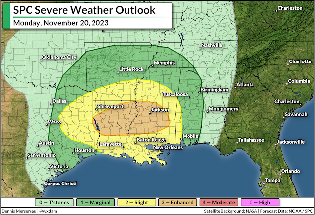
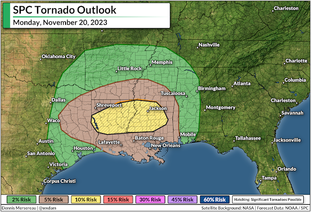
Some of the severe thunderstorms on Monday could grow quite strong across Louisiana and Mississippi, bringing a risk for a couple of strong, long-lived tornadoes.

Fall severe weather season ramps up

'Tis the season for severe weather in the south, and this looks to be our first real "second season" severe weather outbreak of the year. November and December see a noticeable uptick in severe weather across the southeast as powerful low-pressure systems develop over the Plains and roll north toward the Great Lakes.

Warm, humid air streaming north out of the Gulf of Mexico provides the instability, while the storm and its fronts provide the lift and wind shear needed to push the resulting thunderstorms beyond severe limits.

The Storm Prediction Center issued an enhanced risk for severe weather across northern Louisiana and much of southern and central Mississippi during the day Monday. Thunderstorms will develop during the afternoon and sweep across the region from west to east.


All modes of severe weather are possible, but the headline (as always) is the risk for tornadoes. Forecasters see enough instability and wind shear that a couple of those tornadoes could be strong or long-lived in and around the enhanced risk area.

Aside from the tornado risk, any of the thunderstorms that bubble over the region on Monday could produce strong wind gusts of 60+ mph, as well as a risk for large hail.

Make sure you have a way to get warnings

It's been a long while since we've had to contend with a risk for severe weather. Make sure emergency alerts are activated on your phone so you'll know the moment a tornado warning is issued for your location. Make a mental note of all the safe places at home, work, school, and various places you run errands in case dangerous weather strikes during the day.

Much of the severe weather threat on Monday and early Tuesday will unfold after sunset. Severe weather is especially dangerous after dark as people tune out and wind down for the evening. It's more important this time of year than ever to stay weather-aware, keeping up with storms nearby and having a way to receive warnings as soon as they're issued.

Remember—never rely on tornado sirens as your first line of defense. These sirens are outdoor warning systems not meant to be heard indoors, and they're prone to failure in bad weather.

A taste of beneficial rains on the way


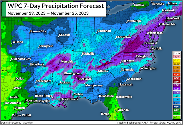
Even with the threat for severe weather, the widespread rain we'll see over the next couple of days is welcome news for just about everyone in the region.

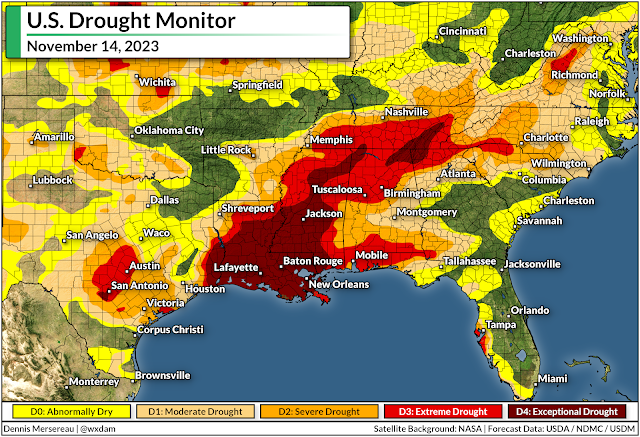
Much of the south has slipped into severe or extreme drought over the past couple of months as dry patterns prevailed and tropical systems largely avoided making landfall on the northern Gulf Coast.


Some areas have seen their annual rainfall totals fall more than a foot behind where they should be by the middle of November. It'll take a lot of rain to ameliorate the growing effects of this extended drought, but even an inch or two of rain is a welcome step in the right direction.

Another low-pressure system could develop in the western Gulf of Mexico late in the week around Thanksgiving, which could bring another quick hit of rain to areas that desperately need the water. Beyond that, we could be in for another dry pattern that'll likely last into the opening days of December.


Follow me on Facebook | Bluesky | Threads | Instagram | Twitter

Get in touch! Send me an email.

Please consider subscribing to my Patreon. Your support helps me write engaging, hype-free weather coverage—no fretting over ad revenue, no chasing viral clicks. Just the weather.


April 3, 2023

Another Round Of Significant Severe Weather Is Likely On Tuesday


Tuesday's severe weather map across the central United States may look eerily familiar if you paid attention to the weather last Friday.

Many of the same areas pummeled by terrible storms a few days ago are at risk for more severe weather over the next 48 hours, with strong tornadoes possible again alongside the threat for damaging winds and large hail.

The Risk

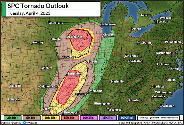
The Storm Prediction Center issued a moderate risk for severe weather—a four out of five on the categorical scale measuring the risk for dangerous storms—across two separate areas.


The first covers eastern Iowa and northern Missouri, while the second blankets much of western Arkansas and a large chunk of southwestern Missouri. These include the cities of Fayetteville, Arkansas; Springfield, Missouri; and Cedar Rapids, Davenport, Iowa City, and Waterloo in Iowa.

Both of these moderate risks are driven by the threat for strong, long-lived tornadoes. The strongest storms here could produce hail the size of golf balls or larger along with damaging winds. 


There's also an enhanced risk for severe weather—a solid three on the five-category scale—stretching from Tyler, Texas, all the way north to Madison, Wisconsin. Areas in and around the enhanced risk could also see tornadoes, some strong and long-lived, as well as large hail and widespread damaging wind gusts.

Nighttime Storms Are A Serious Hazard

It looks like things are going to kick off a little later in the day than they did on Friday, which will push a good chunk of Tuesday's severe weather risk later into the evening and nighttime hours. Severe weather is bad any time of the day, but it's especially hazardous at night.

Folks are at serious risk of missing urgent warnings as they wind down and go to bed. Wireless emergency alerts on smartphones have saved countless lives over the past decade after the screeching tone woke people up and gave them just enough time to dive for cover. It's best to have multiple ways to receive alerts in case one fails—get a weather radio!—but if nothing else, make sure your phone and all your friends' and family members' phones are ready to receive tornado warning alerts.

The other reason nighttime storms are extra dangerous is that it's nearly impossible to see tornadoes at night until they're right on top of you. Like it or not, it's human nature and a cultural idiosyncrasy that we want to see a tornado before taking shelter. That's dangerous during the day, but a straight-up gamble with your life at night.

The Setup

It's worth saying up front that no two severe weather events are ever exactly alike. Not everyone under the highest risks here will see severe weather. There are always "modes of failure," as meteorologists like to put it, that can preclude widespread severe weather.

That being said, the potential certainly exists for Tuesday's storms to produce strong, long-lived tornadoes, as well as widespread damaging wind gusts and hail the size of golf balls or larger.

Another low-pressure system moving out of Colorado will scoot across the Plains toward the Upper Midwest during the day Tuesday. This strengthening storm could moonlight as a model for a textbook illustration of a classic early-spring troublemaker.

Source: TwisterData.com

Cold air to the north, warm air to the south, and an abundance of tropical moisture will allow the system to generate a ripping blizzard over the northern Plains while fueling a significant severe weather risk from Wisconsin to Texas. 

The above model shows Theta-E, which is a good illustrator of instability as it combines temperatures and dew points all in one graphic.

Higher values show a warmer, soupier air, while cooler colors show drier and more stable conditions. This does a really good job showing the center of the low and its associated cold and warm fronts, laying out the general setup that'll fuel Tuesday's severe weather threat. You can also see the stout southerly winds feeding the wind shear that boosts the storms.

Strong supercells are likely near the triple-point, or the area where the cold and warm fronts meet near the center of the low. This accounts for the heightened tornado and large hail risk across eastern Iowa and northern Missouri.

Farther south, another bullseye for the tornado/hail risk exists over western Arkansas and southwestern Missouri as supercell thunderstorms develop amid strong wind shear blowing over the region.

The Severe Risk Continues Wednesday

This low-pressure system will track northeast across the Great Lakes into northern Ontario through Wednesday, which means that the cold front is in no hurry to race to the Atlantic coast. 


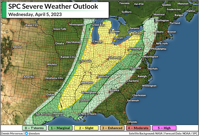
We'll see a renewed round of severe thunderstorms from the Mississippi to the Appalachians during the day Wednesday.

An expansive threat for damaging winds will develop in any lines of thunderstorms that bubble along the cold front on Wednesday, with the risk for isolated tornadoes popping up from time to time.

The SPC mentioned in their forecast on Monday that supercells are possible around the eastern Great Lakes, which could enhance the tornado threat in this region.

Snow And Ice

Severe weather is far and away going to be the biggest threat from this storm, but don't sleep on the risk for serious snow and ice on the cold side of the low.

Source: NWS

Folks across the northern Plains are on alert for blizzard conditions and the potential for two to three feet of snow. The latest forecast from the National Weather Service shows a swath of 12-18+ inches of snow covering a huge area from central Wyoming straight into northwestern Ontario.

This heavy, wet snow will be accompanied by powerful wind gusts that will lead to prolonged blizzard conditions at times. Travel will be impossible for a time during the storm.

Source: NWS

A lengthy period of freezing rain is likely in the murky area between the heavy snow and the strong storms. Plenty of folks across the Upper Midwest could see one-quarter of an inch of ice accretion through Wednesday, which is enough to cause tree damage and power outages.

Even greater ice accretions are likely across interior Maine on Wednesday night, which is certain to lead to tree damage and power outages.


You can follow me on Facebook, Mastodon, Twitter, Instagram, or send me an email.

Please consider subscribing to my Patreon. Your support helps me write engaging, hype-free weather coverage—no fretting over ad revenue, no chasing viral clicks. Just the weather.


March 31, 2023

Central U.S. Faces First 'High' Risk Severe Weather Day In Years


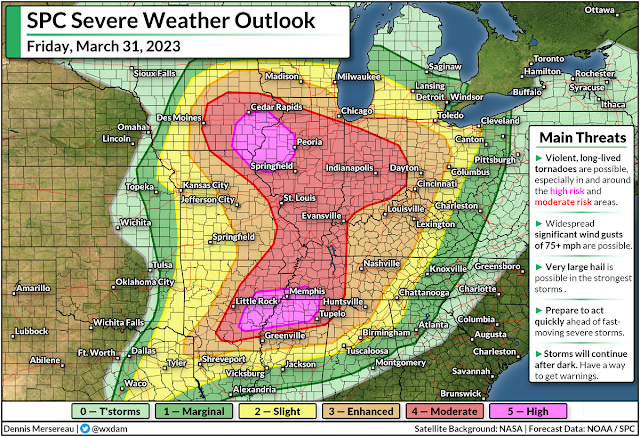
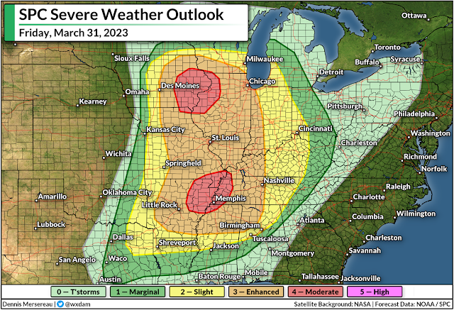
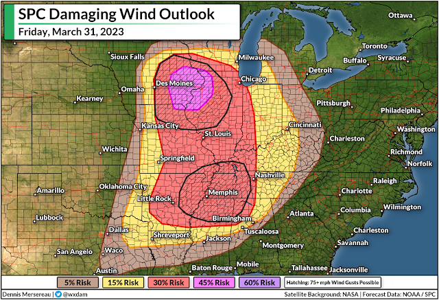
The Storm Prediction Center (SPC) expects a widespread and significant severe weather outbreak across much of the central United States on Friday, including the potential for "violent, long-lived tornadoes," as well as destructive wind gusts of 75+ mph and very large hail in the strongest storms.

This is the first high risk issued by the SPC since March 25, 2021, a day that saw multiple violent tornadoes tear across Alabama and Georgia. This also appears to be the first 'double' high risk—with two distinct bullseyes—in over a decade.

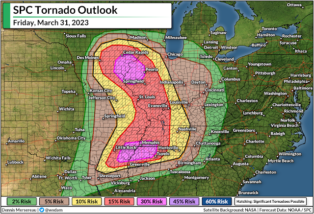
Friday's upgrade to high risk is tornado-driven, according to SPC forecasters, with a better-than-even chance of violent, long-lived tornadoes in eastern Iowa and northwestern Illinois—including Cedar Rapids, Davenport, and Peoria—as well as a swath of the Mid-South, centered around the Memphis metro area.


Areas under the high risk are just where dynamics are approaching peak favorability for significant tornadoes. We still have a very large swath of the country under a moderate risk, including almost the entire state of Illinois, most of Indiana, and large portions of every state bordering the Mississippi River down to Greenville.

Communities in and around the moderate and enhanced risk areas could also see widespread destructive wind gusts, significant tornadoes, and large hail. Many major cities and transportation hubs are included in this sprawling threat for severe weather.

"Particularly Dangerous Situation" (PDS) tornado watches were issued for most of the high risk and moderate risk areas by midday on Friday, with the threat growing through the afternoon hours and spreading east into the overnight.


This wide-ranging severe weather outbreak will push east Friday night into early Saturday morning as the powerful Colorado low responsible for this outbreak tracks across the Great Lakes into Ontario.

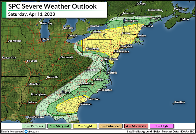
Another round of severe weather is likely on Saturday up and down the East Coast, with damaging winds and isolated tornadoes possible from near the Quebec border down through the Florida Panhandle.

Make sure you've got a way to get warnings and seek safe shelter, and give your friends and family a heads-up if they're in the area.


You can follow me on Facebook, Mastodon, Twitter, Instagram, or send me an email.

Please consider subscribing to my Patreon. Your support helps me write engaging, hype-free weather coverage—no fretting over ad revenue, no chasing viral clicks. Just the weather.
  

March 30, 2023

Widespread Severe Weather Expected Friday Across The Central U.S.


A classic springtime system rolling across the northern U.S. will lead to a widespread risk for severe weather across the middle of the country on Friday.

We've had some potent severe weather already this year—including a devastating EF-4 tornado in Mississippi last week—but this is the widest-ranging severe storm risk we've seen so far this season.

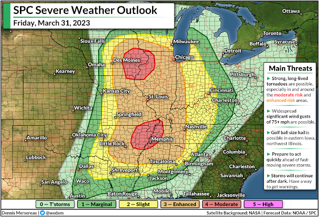
The Storm Prediction Center (SPC) expects severe thunderstorms on Friday from east-central Texas all the way into central Wisconsin, stretching as far east as the Ohio River Valley through the overnight hours into Saturday.

A strong Colorado low sweeping across the Upper Midwest on Friday will sow the seeds for this potential severe weather outbreak. Unstable air streaming north into the low will provide the instability, and powerful upper-level winds will supply the wind shear needed to turn thunderstorms severe.

Source: TwisterData.com

As with most classic springtime severe weather outbreaks, we'll see the hazards play out in two distinct rounds. The initial thunderstorms have the best opportunity to grow into supercells capable of producing strong, long-lived tornadoes, as well as large hail and damaging winds.

These supercells are most likely in and around the two moderate risk areas: near the center of the low in Iowa, and near the greatest instability and wind shear over the Mid-South.

As the day wears on, a lengthy squall line will develop along an approaching cold front, transitioning the threat to widespread damaging wind gusts (60+ mph) and the potential for fast-spawning tornadoes in the kinks along the leading edge of the line. This line will push east late Friday through the overnight hours.


A large area falls under an enhanced risk for severe weather, or a 3 out of 5 on the scale measuring the potential extent of powerful thunderstorms. Two separate areas are under a moderate risk, or a 4 out of 5 on the scale, including eastern Iowa and northwestern Illinois, as well as the Mid-South centered around Memphis.


Strong, long-lived tornadoes are possible throughout most of the Mississippi River Valley between Dubuque, Iowa, and Clarksdale, Mississippi, with the potential for significant tornadoes pushing east into central Tennessee and northern Alabama.


Tornadoes get top billing on red-letter severe weather days, of course, but damaging wind gusts—potentially reaching 75+ mph—are far and away the most immediate threat to any one location. These winds can cause as much damage as a tornado, just over a wider area.

Keep a close eye on watches and warnings if you live in the region, and let your friends and family know to do the same if they're under any severe weather risk on Friday. Have a plan in place to seek sturdy shelter in a hurry if a warning is issued for your location, whether you're at home, work, school, or out running errands.

The threat for severe weather will shift east on Saturday, albeit on a much weaker scale as the low-pressure system lifts into Quebec. Damaging winds and a couple of tornadoes will be possible across parts of the southeastern states, as well as a damaging wind threat in any storms that pop up across the eastern Great Lakes.

Another storm next week could produce significant severe weather across many of the same areas expecting bad storms on Friday. It's that time of year. Stay ready, and stay alert.


You can follow me on Facebook, Mastodon, Twitter, Instagram, or send me an email.

Please consider subscribing to my Patreon. Your support helps me write engaging, hype-free weather coverage—no fretting over ad revenue, no chasing viral clicks. Just the weather.


December 12, 2022

Major Storm Threatens Blizzard, Ice Storm, Tornadoes, Heavy Rain...You Name It


The first real rip-roarin' winter storm of the season is cranking up over the Plains states this evening.

The storm will kick into high gear heading into Tuesday, bringing blizzard conditions and a full-on ice storm to parts of the High Plains, while folks across parts of the south have to deal with the risk for severe thunderstorms and tornadoes.

A fast-developing low over northeastern Colorado will strengthen over the next 12-24 hours as a strong jet stream moves across the Rockies.

This large system will have a little bit of everything for everyone—it'll be one of those classic winter storms that puts on a gorgeous curly display when we gawk at satellite imagery on Tuesday and Wednesday.

The northern side of the storm will have plenty of cold air for heavy snow and freezing rain to fall over the northern Plains.

Forecasters expect the worst conditions to cover communities from northeastern Colorado into the Dakotas.


It's not heavily populated terrain by any means, but it'll be a disruptive storm for folks who live in the area, and it'll make life difficult for cross-country travelers by road and rail.

The latest forecast from the National Weather Service calls for widespread totals of more than a foot of snow across the hardest-hit areas, with more than two feet of snow possible for some (un)lucky towns, especially in South Dakota.

Closer to the track of the low itself, warm air nosing its way into the lower-levels of the atmosphere will lead to a prolonged freezing rain event.

An ice storm warning is in effect for parts of eastern South Dakota, including Brookings, for the potential for 0.25 to 0.50 inches of ice accretion. That's more than enough solid ice to bring down tree limbs and power lines.


A solid stream of warm, moist air pumping north from the Gulf will fuel a widespread risk for severe thunderstorms through midweek. The greatest risk will play out on Tuesday, with the Storm Prediction Center issuing an enhanced risk for severe weather (a 3 on the 1-5 scale) centered on much of Louisiana.

The biggest concern with Tuesday's storms will be the risk for tornadoes. The environment may be capable of producing significant, long-track tornadoes. If you're in or near the region at greatest risk, keep an ear out for severe thunderstorm and tornado warnings and have safe shelter nearby you can reach in a hurry.


Snow, ice, and tornadoes aren't this storm's only risks. We're looking at the risk for several inches of rain across the southeastern states over the next couple of days. This steady march of heavy rain will beef up the potential for flash flooding in vulnerable areas.

This storm will spin itself out (to use the technical term) by Thursday, with its remnant moisture going on to feed the development of another system along the East Coast by the end of the week.


You can follow me on Twitter or send me an email.

Please consider subscribing to my Patreon. Your support helps me write engaging, hype-free weather coverage—no fretting over ad revenue, no chasing viral clicks. Just the weather.