
SEATTLE — Puget Sound Extended Forecast
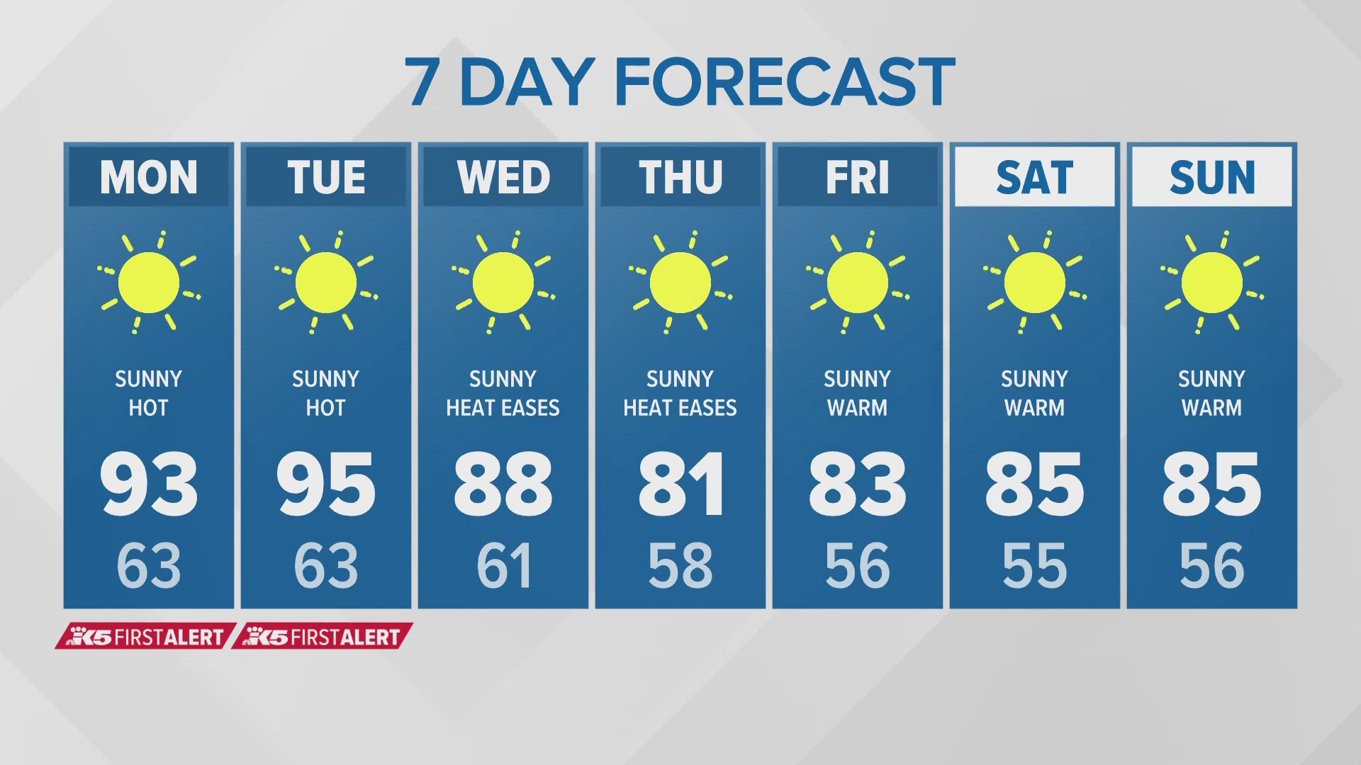
Monday & Tuesday: FIRST ALERT WEATHER DAY! Sunny and hot. Morning lows in the upper 50s to mid 60s. Temperatures peak for most spots into the mid 90s - some of the hottest spots will be in the upper 90s to around 100 degrees.
Wednesday: Sunny and a little cooler. Lows in the mid 50s to low 60s. Highs in the low and mid 80s.
Thursday & Friday: Sunny and cooler. Lows in the 50s to near 60. Highs in the upper 70s to low 80s.
Saturday & Sunday: Sunny and warm. Lows in the mid to upper 50s. Highs in the low to upper 80s.
Discussion
The extreme heat continues - and so does the First Alert Weather activation. The PNW is in the middle of a heat wave, with record-breaking heat continuing into the first half of this upcoming week.
Records broken Sunday include Sea-Tac airport with an observed high of 93 degrees, breaking the previous daily record of 90 degrees. Olympia hit 97 degrees, breaking the previous daily record of 95 degrees.
And it's not just a PNW heat event - the entire west coast is feeling the heat. In fact, Las Vegas hit the hottest temperature ever recorded with a daily high of 120 degrees.
The heat will peak for Puget Sound on Monday and Tuesday, but the coast will start to see a few degrees of cooling as the ridge nudges slightly to the east.
A Heat Advisory remains in place until Tuesday night. The Seattle metro, the Olympic and Cascade valleys will have the highest heat risks, however, heat of this magnitude will affect anyone without adequate cooling. To prevent heat-related illness, it's best to stay hydrated, limit your time in the sun, and find ways to stay cool. Don't forget about your pets and never leave anyone, including your pets, in a parked car - even for 5 minutes!
Additionally, there is a Red Flag Warning in place for the western slopes of the Cascades (mainly above 1,500 feet) through Tuesday night. Low humidity and high temperatures can cause fires to develop and spread rapidly. Smoke from the Pioneer wildfire may drift into the northern/north-central Cascade foothills, which may lead to lower air quality. Elsewhere, drops in air quality are possible because of the stagnant and hot weather pattern in place.
By Wednesday, the high pressure will take up residence near Idaho and western Montana for the remainder of the week. In turn, this should put Puget Sound in a sunny and slow cooling pattern with highs mostly in the upper 70s and 80s by later in the week. Temperatures will still be about 5 degrees above normal but a definite improvement over the coming weekend.
No signs of rain at least for the next 7 to 10 days.