


updated:Fri Aug 08 / 06:50 AM
TODAY:
Hot and humid with a couple of showers and a gusty thunderstorm. High: 91
TONIGHT:
Evening thunderstorm; clouds breaking, humid. Low: 72
TOMORROW:
Partly sunny and humid with a couple of showers and a gusty thunderstorm. High: 87 Low: 70
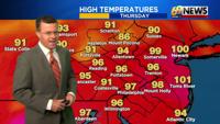
Thursday was the second day of what should be a three-day stretch of 90 degrees or higher for a good portion of the area, and likely the fourth heat wave of the summer of 2024. Highs were mostly in the mid 90s on Thursday, with the high humidity driving the heat index up around 100 degrees at times in the afternoon and evening. There were a few spotty t-storms that provided some temporary relief from the heat, but many places remained dry and in need of some rain. As luck would have it, our chances for more widespread but still scattered showers and thunderstorms will go up over the next few days, with Friday and Saturday afternoons and evenings bringing a decent chance for showers and gusty storms that can produce some brief heavy downpours. While we should eclipse the 90-degree mark for one more day on Friday and heat advisories continue for the 100° heat indices into Friday as well, more clouds will keep highs a bit less hot, mostly in the mid to upper 80s for the upcoming weekend. While the weekend won't be a washout by any stretch, there will be some scattered showers and storms each afternoon and evening, and plenty of humidity despite the heat backing off just a bit. For next week, a pair of cold fronts will help to lower humidity levels, the first one Sunday night and the second one Tuesday night and Wednesday. Outside of a few mid-week showers and storms ahead of that second front, much of next week looks dry, and not as hot or as humid as where we are right now.
DETAILED FORECAST
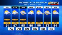
FRIDAY
Presuming we hit the 90-degree mark for the third (and final) day on Friday, then we'll officially have our fourth heat wave of the summer of 2024. Expect a mix of clouds and hazy sunshine and a mostly dry first half of the day, but a better chance, as compared to the last few days, of some more widespread scattered showers and storms in the afternoon and evening. Heavy rain would be the primary localized threat from any thunderstorm, but a stronger storm could also contain some gusty winds. The heat index may approach 100 degrees again Friday afternoon, until any storms have a chance to cool you off. Showers and scattered storms continue into the evening before diminishing overnight, but another warm and muggy night in the low to mid 70s should be the rule under partly cloudy skies.
THIS WEEKEND
While last weekend was warm, dry, and comfy, the first weekend of August looks equally as warm (mid to upper 80s) but also quite humid and rather unsettled. Neither day looks to be a washout, but there will be scattered showers and storms both Saturday and Sunday, primarily afternoons and evenings, with some heavier downpours possible in any storms. So it won't rain all or even most of the time, but it can rain hard when it does given the high humidity. So any outdoor plans this weekend, like Musikfest for instance, should prepare for inclement weather when those scattered storms inevitably pop up. But it won't rain everywhere equally, so there will be a hit or miss nature to the weekend storm activity. There will be some hazy sun, but more clouds and those rain chances will keep us out of the 90s, with seasonably warm highs around 83-88° likely both weekend afternoons, and overnight lows again around the 70-degree mark.
EARLY NEXT WEEK
If a cold front that comes through Sunday night continues to settle to our south Monday into Tuesday, it should provide lower rain chances, and likely mostly if not entirely dry weather Monday and perhaps Tuesday too. Highs will remain in the mid to upper 80s, close to average for early August, and the humidity may come down ever so slightly as well, but things don't look to be in the comfortable range just yet. The next chance of showers and storms would be with a cold front for the middle of next week, likely Tuesday night or Wednesday, and then another shot of comfort may follow later in the week along with more dry and sunny weather.
TRACK THE WEATHER: