- News
- City News
- delhi News
- Delhi weather: 100mm rain in 1 hour on Friday, 25% more than entire June's quota
Trending
Delhi weather: 100mm rain in 1 hour on Friday, 25% more than entire June's quota
Extreme rainfall events, like the recent cloudburst at Safdarjung, are becoming more frequent and intense in north India. The convergence of multiple weather systems, as observed by experts from the University of Reading, has been identified as a key factor contributing to the increased risk of flooding in the region.
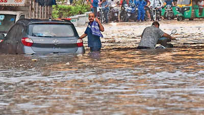
NEW DELHI: Safdarjung received 25% more rain in one hour on Friday morning than it normally gets in the entire month of June as a deadly interaction of multiple weather systems led to a cloudburst over areas in central Delhi.

While Friday's convergence of multiple systems was localised over a very small region, this was the third instance in less than two years when extreme rain in the city was caused by an interaction of two or more weather systems.Worryingly, experts and climate models suggest these types of events are likely to increase in frequency and intensity with climate change.
"Between 5am to 6am, Safdarjung recorded nearly 100mm of rain. It was a cloudburst phenomenon with the maximum rain concentrated around the Safdarjung station," IMD chief Mrutyunjay Mohapatra told TOI.
So, what caused such extreme rainfall, the highest single-day spell at Safdarjung since 1996 and the highest in June since 1936? "At that time, two circulations, one over Haryana and another over south Rajasthan-Gujarat, were bringing some moisture from the Arabian Sea. At the same time, there was a low-pressure system over Bay of Bengal near the Odisha coast that was energising the southwest monsoon and pushing these winds towards northwest India. The circulations in the north also attracted the monsoon towards the region, leading to its swift movement towards Delhi-NCR," Mohapatra said.
He said the final piece in the mix was a high-pressure system in the upper layers of atmosphere over Delhi that caused convergence of winds in the lower layers, leading to perfect conditions for intense thunderstorms. "It was a multiple-scale interaction which caused extreme rainfall over a very narrow region. In technical terms, it was a mesoscale convection system," the IMD chief said.
While Friday's conditions differed significantly from previous instances, it was nonetheless the third multi-system convergence causing heavy rain in the capital in less than two years. The previous instances were in July last year and Oct 2022.
These weather interactions have become a prime cause of extreme rainfall in north India in recent years, including the catastrophic Kedarnath deluge of 2013. And climate change could be adding to their destructive potential. "We can be fairly certain that these interactions, when they do happen, will be increasingly linked with extreme rainfall and flooding," said meteorologist Kieran Hunt from the UK's University of Reading, who has been researching on two-system interactions over India.

While Friday's convergence of multiple systems was localised over a very small region, this was the third instance in less than two years when extreme rain in the city was caused by an interaction of two or more weather systems.Worryingly, experts and climate models suggest these types of events are likely to increase in frequency and intensity with climate change.
"Between 5am to 6am, Safdarjung recorded nearly 100mm of rain. It was a cloudburst phenomenon with the maximum rain concentrated around the Safdarjung station," IMD chief Mrutyunjay Mohapatra told TOI.
The normal rainfall for the month of June at Safdarjung is 80.6mm. In a single hour, the month's normal was exceeded by 25%. The day's rainfall, at 228.5mm, was nearly four times the June normal.
So, what caused such extreme rainfall, the highest single-day spell at Safdarjung since 1996 and the highest in June since 1936? "At that time, two circulations, one over Haryana and another over south Rajasthan-Gujarat, were bringing some moisture from the Arabian Sea. At the same time, there was a low-pressure system over Bay of Bengal near the Odisha coast that was energising the southwest monsoon and pushing these winds towards northwest India. The circulations in the north also attracted the monsoon towards the region, leading to its swift movement towards Delhi-NCR," Mohapatra said.
He said the final piece in the mix was a high-pressure system in the upper layers of atmosphere over Delhi that caused convergence of winds in the lower layers, leading to perfect conditions for intense thunderstorms. "It was a multiple-scale interaction which caused extreme rainfall over a very narrow region. In technical terms, it was a mesoscale convection system," the IMD chief said.
While Friday's conditions differed significantly from previous instances, it was nonetheless the third multi-system convergence causing heavy rain in the capital in less than two years. The previous instances were in July last year and Oct 2022.
These weather interactions have become a prime cause of extreme rainfall in north India in recent years, including the catastrophic Kedarnath deluge of 2013. And climate change could be adding to their destructive potential. "We can be fairly certain that these interactions, when they do happen, will be increasingly linked with extreme rainfall and flooding," said meteorologist Kieran Hunt from the UK's University of Reading, who has been researching on two-system interactions over India.
End of Article
FOLLOW US ON SOCIAL MEDIA


Hot Picks
TOP TRENDING
Trending Stories
In City
Entire Website
- Cody Rhoades talks about his potential heel turn
- ICC T20 World Cup winners list with captains from 2007 to 2024
- WWE Money In The Bank 2024 kickoff event date and timings
- Je'Von Evans teams up with NXT champion, Trick Williams to take on their opponents ahead of NXT Heatwave showdown
- Mercedes Moné reveals being devastated when she heard the news of Saraya’s retirement due to an injury inflicted by her
- Remembering one of the best Money in the bank in WWE history - 2016
- The American Nightmare in the new ad for The Boys Season 4
- Wendy Choo ridicules Carlee Bright, calling her Kelly Kelly’s daughter, Kelly responds in support of Bright
- Gallus vs Tyson Dupont and Tyriek Igwe's backstage duel resulted in NXT match cancellation
- A new match has now been added to the NXT Heatwave showdown
- Kamala blooms as debate debacle threatens to tank Biden bid for second term
- Change of guard in Jharkhand: Why Hemant Soren has moved fast to return as CM
- Rahul once described power as poison. What's changed now?
- Flyers left in lurch for Team India? DGCA seeks report from Air India
- After Rahul's claims, Army issues clarification on Agniveer compensation
- UK general elections: 10 things you need to know
- No loo breaks, brutal targets - life inside an Amazon warehouse
- Europe does to Chinese shopping websites what India did in 2020
- WH pushes back on reports of Biden's withdrawal
- BJP leader LK Advani admitted to hospital, condition stable

Popular Categories
Hot on the Web
Top Trends
All Time T20 WC WinnersParliament Session 2024CUET UG Answer Key 2024Roman ReignsZika Cases in PuneIndian Team FlightHathras Stampede AccidentMoney in the Bank 2024 PredictionsHathras Stampede5 Best Matches of Braun StrowmanList of International Cricketers Who Retired in 2024Rishi ShahCody RhoadesCricket NewsWWE NewsLive Score
Trending Topics
US Independence Day 2024Bigg Boss OTT 3 ContestantsNational AnimalsFunniest ImagesSalaar 2Kalki 2898 AD Movie ReviewMirzapur 3Harshika Poonacha Pregnancy NewsPrafull BillorePisces HoroscopeAquarius HoroscopeCapricorn HoroscopeSagittarius HoroscopeScorpio HoroscopeLibra HoroscopeVirgo HoroscopeJio Hike TariffWhy Earth Has One MoonMattress Buying GuideUpcoming Smartphones In July
Living and entertainment
Latest News
Despite T20 World Cup debacle, 'major surgery' unlikely in Pakistan Cricket; only 'cosmetic changes'9. Good week for Imran, acquitted in one more caseThese areas of Chennai to face power cut FridayJe'Von Evans teams up with NXT champion, Trick Williams to take on their opponents ahead of NXT Heatwave showdownHonkai Star Rail codes for July 2024: Win 10K credits and know the steps to redeem the codes7. Lady Liberty comes calling'Mother did the same': BJP accuses Rahul Gandhi of stirring ruckus in Lok Sabha during PM Modi's speech, shares videoSathyaraj's new look sparks excitement among fans on social media!Roblox All Star Tower Defense (ASTD) codes for July 2024: Win stardust, gain gems and know how to redeem the codesTWICE reveals mirror teaser images showcasing Nayeon, Jeongyeon, Momo, and Sana for their upcoming 5th Japan album 'DIVE'Best Republic Day tableau: Odisha wins first prize; Gujarat bags top position in people's choice categoryShould you stay invested in Quant MF after Sebi probe?Virgo Yearly Horoscope Prediction 2024: You will get financial stability this yearLong Kurtis for Women: Must Haves For Added Elegance In Your WardrobesNayeon of TWICE sets record on Billboard 200 with two albums, a milestone for k-pop soloistsJillian Bell to make his directorial debut with ‘Summer of 69’ comedy for Hulu, starring Chloe FinemanKhatron Ke Khiladi 14's Abhishek Kumar reacts to Munawar Faruqui's wedding, says 'Maine usse bola Bhabhi ko hi bolna'BJP-Shinde regime forced RWITC to agreement, Aaditya Thackeray slams Mahalaxmi racecourse 'deal'
Copyright © 2024 Bennett, Coleman & Co. Ltd. All rights reserved. For reprint rights: Times Syndication Service