Showing posts with label transit. Show all posts

Catch the London Underground with Google Maps

Thursday, July 28, 2011 | 1:00 AM


Today, Google Maps added public transport directions for London within Google Maps, including Google Maps for mobile on iOS, Blackberry, and Android-powered devices. Now, whether you live in London or are just visiting, you can get public transport directions on your mobile device.


Public transport directions in Google Maps for Android


Google Maps for mobile uses your current location to determine the best trip to your destination. Just search for your destination location, select it on the map and choose the “Directions” option. The suggested trips will be based on your location by default, and provide you multiple alternatives whenever possible.

If you’re using an Android-powered device, you can also get public transport directions with Transit Navigation (Beta) in Google Maps. With this feature, you’ll get alerts when it’s time to get off the bus or train at your destination or to make a transfer. We hope that public transport directions in London make getting around town more convenient!

Know when your bus is late with live transit updates in Google Maps

Wednesday, June 8, 2011 | 4:00 AM


(Cross-posted on the Official Google Blog)

Often when I’m taking public transit, I arrive at my stop on time only to anxiously check my watch and look down the street for my bus, which is running late once again. Those extra minutes I’m forced to wait seem like an eternity, and the only information I can access on my phone is when the bus was supposed to arrive.

Starting now, Google Maps for mobile and desktop can tell you when your ride is actually going to arrive with new live transit updates. We partnered with transit agencies to integrate live transit data in four U.S. cities and two European cities: Boston, Portland, Ore., San Diego, San Francisco, Madrid and Turin.


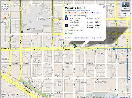
When you click on a transit station or plan a transit route with Google Maps and there are delays or alerts related to your trip, you’ll now see “live departure times” (indicated with a special icon) and service alerts.


Live transit departure times after tapping on a station


Live service alerts when receiving transit directions


Live departures and alerts on desktop


We’re working with our public transit partners to help them provide live data to more people in more cities. You can get live transit updates in the latest version of Google Maps for mobile (requires Android 1.6+), as well as Google Maps on all supported desktop and mobile browsers.

Google Maps for Android Helps You Find the Right Place, Catch a Train, and Add Latitude Friends

Tuesday, June 22, 2010 | 10:55 AM

Hot off the presses, Google Maps for Android version 4.3 has added a couple new features to help you quickly choose the right place to grab dinner, catch the next train, and find friends to add in Latitude.

Have you ever had to make a split decision for dinner plans while on the go? Now, you can see a snapshot of what people are saying about places right on search result pages. Instead of poring through full reviews, you can start by looking at what the most frequently mentioned aspects about a place are, such as food, service, atmosphere, or anything else people keep mentioning. Just like on Place Pages for your computer, the color-coded bar gives an overview of how positively people are talking about any individual aspect. Tap one to see more details like the actual review snippets. Whether you’re looking for top-notch service or a vibrant ambiance, you can now pick just the right place to go.


You’ll also find a new addition to public transit station pages: upcoming schedules. Select any transit station icon directly from the map and open its page by tapping the window. You’ll find a handy list of the next departure times for any subways, trains, or buses that are leaving from that station where transit info is available.


In Google Latitude, we wanted to make it even easier for you to find friends and family with whom you’d like to share your location. Right at the bottom of your Latitude friend list, you’ll be able to quickly start sharing your location with long lost friends, loved ones, and others from your Google Contacts. Add any suggested friends by tapping the + icon and sending them a sharing request. Tap the x and they’ll be dropped from your suggested friends list. Don’t worry -- you can always add them later by choosing “Add friends” from the Latitude menu.


Get the latest version of Maps by searching for Google Maps in Android Market from Android 1.6+ phones. If you’re reading this on your phone, just tap here. Version 4.3 is available in all the countries and languages where Maps is currently available.

Visit our Help Center to learn more, ask questions in our Help Forum, or give us suggestions and vote on other people’s on the Mobile Product Ideas page.

NYC subway maps in your pocket with Google Maps for mobile

Friday, November 6, 2009 | 12:10 PM

Hey New Yorkers looking for somewhere to celebrate the Yankees' 27th World Series title? It's now easier than ever to carry a NYC subway map in your pocket.

A few weeks ago we announced the Layers feature on Google Maps for BlackBerry, Windows Mobile, and Symbian S60. Today we added a layer that overlays NYC subway routes on a map. We hope this will help you quickly navigate the New York City subway system. To see this new layer while viewing a map of New York City, just click the Layers menu and then turn on the Transit Lines layer.

Of course, you can also get step-by-step public transit directions by using the "Get Directions" menu, and then selecting the public transit icon. You can learn more about updates to Google Transit in the United States and Europe on the Google LatLong Blog.

To download the latest version of Google Maps for mobile with Layers, visit m.google.com/maps from your smartphone.

Search by voice and transit directions come to Google Maps on Android

Sunday, June 14, 2009 | 4:23 PM

Today we're releasing an upgrade to Google Maps for Android-powered phones. We've added a whole host of new features and fixed a few issues with Google Latitude.

You can now search Google Maps for Android using your voice, making it easier than ever to look up places while on the go. Whether you're searching for an address, a business, or nearby windsurfing spots, just speak your query and Google Maps will find it. Our voice recognition engine currently understands English in American, Australian, and British accents. After you search, you'll see a map of places. To help you decide where to go, we've improved our business listings to include content such as store hours, prices, ratings, and reviews.

We also added transit and walking directions to Google Maps for Android. You can now get directions using public transportation in over 250 cities, including New York City and San Francisco. If you're looking for the best route on foot, use walking directions to take advantage of pedestrian-only pathways and to avoid one-way restrictions - just in time for summer!

Google Maps for Android includes some big improvements to Google Latitude. We fixed an issue that caused background location updates to periodically stop for some of you. Now, once you select "Detect your location" from the Latitude privacy menu, your location will continue to update as long as your phone is on.

You may also notice a new experimental feature called Updates that lets you communicate with friends and post messages. Start Latitude and click the "Updates" tab to shout out updates at friends when they're at interesting locations, start a conversation when you're at your favorite restaurant, or just add more details to your Latitude location for your friends to see. Your friends will also need to download this new version of Google Maps for Android in order to use this experimental Updates feature -- they will not get your messages otherwise.

Unlike past Android software updates for the T-Mobile G1 or HTC Magic, the new Google Maps release won't be automatically pushed to your phone over the next few days. Instead, the upgrade is available for download in the Android Market. Just search for "Google Maps" and install today.

UPDATE: For those of you looking for Street View in Google Maps on Android, you'll find that we've integrated it more tightly with the rest of the app. Street View is no longer its own map mode. You can now check out Street View directly from any search result where imagery is available. You can also long-press any point on the map, in map view or satellite view, and you'll see a Street View thumbnail wherever imagery is available.

By Ole CaveLie and Chandan Pitta, Software Engineers

Get public transit directions in New York with Google Maps for mobile

Tuesday, September 23, 2008 | 4:54 AM

Now that Google Maps can give you subway, train, bus, and ferry directions in New York City, it's a handy tool for planning a night on the town. But what if your plans change while you're at dinner?

Luckily, Google Maps for mobile can give you the same public transit directions right on your cell phone! You can plan trips throughout the New York metro area, including turn-by-turn walking directions. With the My Location feature, most cell phones can automatically set the starting point for your trip, even without GPS. And satellite view and Street View (on selected devices) can show you a preview of where you're going.

With Google Maps for mobile in your pocket, you can go wherever the evening takes you, secure in the knowledge that it'll be easy to figure out how to get there. Google Maps for mobile with public transit directions is available for Blackberry, Windows Mobile, Symbian Series 60, and many Java-based phones. Download it by visiting http://m.google.com/nyc in your mobile phone's browser.

Transit directions: Now on S60 & Windows Mobile

Wednesday, July 30, 2008 | 11:38 AM

A few weeks ago we released Google Maps for mobile with Transit directions for BlackBerry and Java-based handsets. Now, with the release of version 2.2 of the application for Symbian S60 (3rd edition or later) and Windows Mobile (2005 or later), we're happy to say that Transit directions will be available to a bunch more smartphone users around the world.

Transit directions on these platforms work just like they do on the BlackBerry version of the app (watch the demo video). Simply bring up Directions from the main menu and you'll see a second tab labeled Transit (or Public Transport), where you can request a route using only public transportation. You'll receive a number of alternatives that take you (car-free) to your destination. Transit directions are available on Google Maps in more than 50 cities. So whether you live in or are passing through Zurich, Ottawa, Bordeaux or Chicago -- and plenty of places in between -- you can have Transit schedules in your pocket at all times. Stay tuned as we continue working with transit agencies to support more and more cities across the globe!

You'll find a number of other features in this new version of Google Maps for mobile for WinMo and S60: star-ratings for businesses will help you get a feel for what other people think, your search results show up faster than ever, and user-generated content will now surface in your search results -- opening up a whole new world of geo content on your phone. Look for the blue result markers when you search for "ruins in london," for example.

To get this latest version of Google Maps for mobile with Transit, simply point your mobile browser to google.com/gmm. Happy trails.

Get bus and train directions on the go with Google Maps for mobile

Thursday, June 5, 2008 | 11:04 AM

Joe Hughes, Software Engineer

Ever since Google Maps added public transportation directions for San Francisco, it's been a lot easier for me to figure out which buses and trains will get me where I'm going around town, so that today's gas prices take less of a toll on my wallet. Even so, I've often found myself wishing that I had an easy way to get transit directions while I'm out and about.

Enter the new version of Google Maps for mobile. This version (2.2) allows you to get transit directions in all the same places as the web version of Google Maps, including Chicago, the San Francisco Bay Area, Seattle, Vancouver, and over 40 other cities in North America.

This version of Google Maps for mobile even has a few tricks not yet available on the desktop version of Google Maps. For instance, you can find the last transit trips of the day (to figure out how late you can stay at the party) and more easily browse through earlier or later trips. The My Location feature, available on most phones, also makes it easier to set the start point of your journey.

To see how the transit feature of Google Maps for mobile works, take a look at this quick video walkthrough with my co-worker Ryan:


This version of Google Maps for mobile also includes a bunch of other goodies, like faster searching on BlackBerry devices and star ratings for businesses. It's currently available for BlackBerry devices and many other Java-based phones. To download it to your phone visit http://www.google.com/gmm from your phone's web browser or on the desktop.

We're working to bring public transit directions to Google Maps on other devices, so stay tuned!