My Places as a simple way to manage the Places you’ve starred and recently viewed
Descriptive terms for Places in search results
Add a new Place on-the-go when checking in
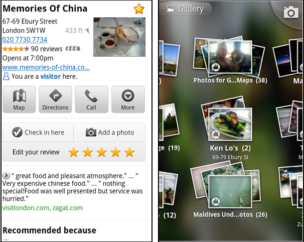
Photo upload for a Place
When deciding on a place to go, people often want to know what a place looks like in addition to seeing ratings and reviews. You can now contribute photos to help others get a sense of places. You can now attach your photos to Places, and yours may even become the profile picture for that page. If you want to view or delete any photos you’ve contributed to Places, you can manage uploaded photos in the “Photos for Google Maps” album on your Picasa account.
Left: Uploading pictures to a place. Right: Photos in Android Gallery
My Places and descriptive terms for mobile
In June we announced descriptive terms and ‘My Places’ for the desktop. Both these features are now in Google Maps for mobile. Descriptive terms appear in search results for Places to inform you what businesses are ‘known for,’ such as their ‘eggs benedict’ or being ‘worth the wait.’
Also, My Places for mobile provides quick access to starred and recent Place pages you’ve looked at. You can access My Places by pressing your phone’s menu button while in Google Maps.
Descriptive terms and My Places in Google Maps for mobile
Add a new Place ‘on-the-go’ for check-ins
If you’re out and about and want to check in, we want to make sure you can quickly add a new Place to check into if one isn’t available. This might happen for new businesses or those that haven’t set up a Place page yet. For example, let’s say you’re at Xoogle Xtreme Sports, a new sports shop in your neighborhood. You go to check in but don’t see Xoogle in the list of places to check into and when you do a search still nothing comes up.
Add a Place when checking in, if needed
To solve this, you’ll now see an “Add place” option at the bottom of suggested places. Select that option, and you’ll be prompted to confirm the name and location of the new place. Then a brand new place is added (and you’re checked in). This place will be available for you and others to check into from Latitude, but will not appear as a search result in Google Maps or Google Places.
We’ve also added ‘Bigger text’ to our experimental Labs features and ‘Download map area’ has been renamed ‘Pre-cache map area.’
To start using Google Maps 5.8 for Android, download the update here. This update requires an Android OS 2.1+ device and can be used anywhere Google Maps is currently available. Learn more in our help center.
Last December, the release of Google Maps 5.0 for Android ushered in the next-generation of mobile maps where you can rotate, tilt, and zoom in and out of 3D maps. Whether you’re on the go or playing with a new phone, seeing a 3D skyline spring up in New York City, Zurich, Milan, and other cities is a helpful, fun, and unique experience--an experience we want as many of you as we can to have for your city.
Almost five years ago, we launched Google Maps for mobile to help you get where you needed to go from your phone instead of a paper map. Today, more than 100 million people a month are now using Google Maps for mobile to get from point A to point B, find nearby places, and more.
Over the past five years, Maps for mobile has changed quite a bit, adding more ways to help you explore the world around you. With My Location, you can quickly find where you are on the map with or without GPS. You can put your friends on the map with Latitude. Navigation even turns your phone into a free internet-connected navigation system with voice guidance and Street View imagery.
Google Maps for mobile through the years (click to see larger image).
Lately, we’ve been especially focused on helping you find the right place at the right time. With recent additions such as Place Pages, you can now pick a nearby place by browsing information such as opening hours and review snippets for the places around you. It’s easier than ever to find those places with Search by voice or the new Places icon on Android. With this latest Android version, we’re happy to see that you’re now searching for places almost three times as often, doubling how many Place Pages are seen a day.
Search result page for Java-enabled phones in 2005 (left) and Place Page for Android-powered devices in 2010 (right).
Search experience in 2005 (left) and Places for Android-powered devices in 2010 (right).
We hope this is just the start of how Google Maps for mobile will continue to evolve and let you explore the world right from your phone. We’re always inspired by how you’re using Maps, and we’d love to hear about a time when you found the nearest mechanic for a flat tire or discovered that hidden gem of a burger joint. If you have a Google story about when Maps for mobile has helped you, please tell us about it. You can also share quick stories on Twitter @googlemobile, and we’ll share our favorite ones. From all of us here on the Google Maps for mobile team, 100 million thank yous for getting your Google Maps to go!
If you’re a business owner, help millions of people find you by claiming your free Place Page available in Google Maps and our most used mobile “app” -- Google Search. Get started at places.google.com/businesses.
Posted by Vic Gundotra, Vice President of Engineering
We understand that typing on phones isn’t as easy or fast as talking into them. As a result, we’re big fans of letting you search in Google Maps for mobile in the most natural way possible -- with your voice! Not wanting the BlackBerry and Android folks to have all the fun, today we’re happy to announce Search by voice in Google Maps 4.1 on Windows Mobile and Symbian S60 phones.
Search by voice lets you easily search for anything by simply speaking your search terms instead of typing them. Just open Google Maps, press your phone’s “call” button, and clearly speak your search term like “Park Plaza.” Search by voice works with all the kinds of searches Google Maps for mobile already supports, including places, addresses (1600 Amphitheatre Parkway), specific businesses (The French Laundry), or types of businesses (sushi restaurants new york).
You may also notice a few other additions, including a redesigned settings page with Search by voice language choices. Choose your preferred language from the supported options, including multiple English accents and Mandarin Chinese. Also, if you find a problem with any information in Google Maps, you can use the “Report a problem” option to let us know.
To get started, install the latest version of Google Maps for mobile 4.1 for Windows Mobile and Symbian S60 by going to m.google.com/maps in your phone’s standard web browser (e.g. Internet Explorer on Windows Mobile). This update is available in all the countries and languages where Google Maps for mobile is currently available.
Visit our Help Center to learn more or tell us your feedback and questions in our Help Forum. Give us suggestions and vote on other people’s on the Mobile Product Ideas page.
Posted by Yuliang Wang and Yifei Zhang, Software Engineers, Google Mobile Team
With Google Buzz for mobile, you can choose to post publicly and include your location, providing context for your followers and allowing others to see what you have to say about a place on a map. We’ve received a lot of requests to make the Google Buzz layer available on desktop Google Maps, and today we're doing just that.
Now you can use Google Maps from the comfort of your computer to find out what people are saying about places near and far. If you’re new to the public Google Buzz layer, check out some tips for exploring the Buzz layer on Google Maps for mobile to see a few of the fun ways people have already been using it on their phones, sharing everything from breaking news to restaurant recommendations.
To view the Google Buzz layer from your computer, go to Google Maps in your web browser and select Buzz from the More... menu in the top right corner of the map. Find an interesting area like your neighborhood and select any available icon to see what’s going on there. In the post’s window, click on the name to see the author’s public profile, the timestamp to comment on the post, or the place to see it in Maps. The Google Buzz layer is available for maps.google.com in all currently supported languages.
The desktop layer is view-only, however, you can post using Google Buzz for mobile from the web app (buzz.google.com) on your phone, Google Maps for mobile, the Android widget, and more.
Posted by Ana Ulin and Evan Parker, Software Engineers, Google Mobile and Maps teams
We’ve been rolling out new versions of Google Maps for mobile at a fast pace lately, and the first Google Maps for BlackBerry update of 2010 is a big one. For version 4.0, we’ve added new features to help you find places faster, post from those places with Google Buzz, star them for quick access, and more.
Search by voice For starters, we’ve added Search by voice to all BlackBerry devices to save your overworked thumbs. Simply press and hold the green “call” button, speak your search, and see your results quickly appear without typing a single letter. Try it now for any search, like the name of my favorite hometown pizza place, “Punch Pizza in Minneapolis.” You can also search by voice for addresses like “802 Washington Avenue Southeast” or search for other another pizza place to try by speaking, “pizza restaurants.” Currently supported languages include multiple English accents and Mandarin Chinese.
Google Buzz Google Buzz for mobile also makes its debut on BlackBerry phones in Google Maps 4.0 (see availability). Use the Google Buzz layer to see what’s going on around you or to post to the layer yourself. Check out the many ways to explore the Buzz layer in Google Maps for mobile, including sharing pictures, news, and more. From the Maps main menu, select Layers > Buzz to enable the layer; open the menu and select “Post Buzz” to add your own public post from a location or place.
Take your searches and starred places to go. Just like in Google Maps on Android, the BlackBerry version now provides personalized search suggestions from your maps.google.com search history. If I previously searched for “Punch Pizza” at home, I can simply type “pun” into Maps on my phone to see “Punch Pizza” at the top of the suggested search terms. Make sure you’ve signed in to your Google Account (Menu > Sign In) and have Web History enabled for your account.
Signing in to your Google Account also synchronizes starred items between maps.google.com on your computer (My Maps > Starred items) and phone (Menu > Starred Items). I’ll do my heavy pizza research at home, star several pizzerias I want to try, and browse the list in Google Maps on my phone when I’m ready to eat.
Wait, there’s more! Also check out other new features added with 4.0:
Use Labs to try experimental features like the Scale Bar or Terrain layer (great for hiking enthusiasts!).
See nearby businesses at an address or location by selecting a point from the map.
Report a problem with the map data or a business listing.
To get started, install the latest version of Google Maps 4.0 for BlackBerry by going to m.google.com/maps in your BlackBerry’s Internet Browser. The update for BlackBerry Enterprise Server administrators and users, including support for BlackBerry OS 5.0 phones, is available here.
Visit our Help Center to learn more or tell us your feedback and questions in our Help Forum. Give us suggestions and vote on other people’s on the Mobile Product Ideas page!
Posted by Ole CaveLie, Software Engineer, Google Mobile Team
Here at Google we’re really excited about the promise of tablet computers, which will be great for browsing the web and using apps. We’ve been working hard to optimize our services for the new format - larger touchscreens, increased portability, rich sensors - and we’d like to share some information about our progress so far.
While surfing the web on your iPad, we expect many of you will want to check your Gmail. If you go to gmail.com in your browser, you’ll see something different than what you’re used to on the desktop. We’re releasing an experimental user interface for the iPad built on the Gmail for mobile HTML5 web app that we launched last year for the iPhone and Android devices. Those devices have large screens compared to other phones, and tablets like the iPad give us even more room to innovate. To take advantage of the iPad’s large display, we’ve created a two-pane view with your list of conversations on the left and messages to the right.
To try this new interface, go to gmail.com in your browser. We recommend adding a homescreen link for easy access. As this interface is experimental, expect changes as we continue to develop and optimize. Also, please let us know any ideas or feedback that you have. You can also access Gmail on the iPad through the native Mail app using the IMAP protocol.
Additionally, the iPad ships with a number of Google services pre-installed. As with Mac computers and the iPhone, you’ll find Google Search in the top right corner of Safari. The YouTube app for iPad is built-in, so you can watch HD videos and read and write comments. The new Maps app on iPad takes advantage of high-resolution satellite and Street View imagery, includes a new terrain view, and lets you search for local businesses and get directions. Just like on the iPhone, you can also go to the App Store to download Google Mobile App with search by voice. Of course, Google Mobile App was originally designed for the iPhone’s screen dimensions, but we’ve adapted it to work on the iPad and we’re looking into new ideas to make the app even better.
As you use Google’s web-based applications on iPad, you’ll notice that you sometimes see the desktop user interface and other times you see the mobile interface. We’ve evaluated the behavior of each Google web app using the iPad Simulator, and we are serving the interface we feel works best. If you’d like any help using our products on iPad, please click the 'Help' link within the product.
We’re particularly excited by how tablet computers create the opportunity for new kinds of user interaction. Here on the mobile team, we often talk about how mobile devices are sensor-rich: they can sense touch through their screens, see with a camera, hear through a microphone, and they know where they are with GPS. The same holds true for tablet computers, and we’re just starting to work through how our products can become even better on devices like the iPad.
Update on April 4, 2010 @ 12:30 AM: The new Google Mobile App for iPad is currently not yet available in the App Store. The version that you can download now is the iPhone/iPod touch version.
Update on April 13, 2010 @ 11:40 AM: The new Google Mobile App for iPad is now available in the App Store.
Posted by Punit Soni, Product Manager, Google Mobile
We’ve previously given you a fewtips on using Google Buzz for mobile, and today we’re focusing on the Buzz layer in Google Maps for mobile. As many of you have found out, location puts a different spin on Google Buzz, adding context to posts and letting anyone find relevant public posts in a natural way -- on a map! We wanted to share some tips on a few creative ways we’ve seen you using the Google Buzz layer.
Explore the world around you Are you curious if there’s anything interesting going on nearby? Enable the Buzz layer in Google Maps, then select any icon from the map or open the list view to see all the posts from the map area you’re viewing. We’ve found patients chatting from different hospital rooms, neighbors discussing a power outage, and even some public flirting. Here are a few more awesome examples we’ve stumbled upon:
A father hearing his baby’s first heartbeats at the hospital
Status updates of a rooftop fire being put out in San Francisco
Shooting of the TV show “Trauma” on location
Photos of the stadiums being built for the World Cup in South Africa
Ask questions and get answers If you’re exploring a new area and looking for tips, post a question, and someone browsing Buzz in the area may be able to provide a quick answer. A few weeks ago on President’s Day, I was hanging out in the Russian Hill neighborhood of San Francisco. Rather than take my chances, I posted a question asking what the parking rules were. A friendly local soon informed me that I’d be free of parking stress -- meters were enforced but permit parking was not.
Share a picture worth a thousand words Even if you could type 100 words a minute from your phone, sometimes a picture tells a different story than words could ever describe. Google Maps for mobile or the Android Buzz widget lets anyone share a picture of their favorite dish or the funny street sign they’ve found. Just attach a photo to your post or take a new one before posting. We’ve found great cases of citizen photo journalism on the public Google Buzz layer, such as traffic accidents blocking roads and location-tagged Picasa Web Albums showing the earthquake recovery in Haiti.
Give tips or learn about places Google Buzz posts you create in Maps will always include your location (i.e. “My Location”) by default, but you can easily change the approximate location to a specific place, such as a restaurant. For example, change the post’s location and select the restaurant from the suggestions list before posting to give a recommendation or tip. Alternatively, you can search for the restaurant in Maps and select the Google Buzz option from the search results page (the post’s location will automatically be the restaurant). Now, people reading your post will know that your recommendation is about that exact restaurant, and your recommendation will be available for anyone browsing that restaurant’s search results page.
...and one reminder Because we built Google Buzz in Maps for mobile to let you share information about places with the world, posts from Maps are always public to the web and include a location, either your approximate one or a specific place you choose.
To get started, install the latest version of Google Maps 4.0+ on your Android 1.6+, Windows Mobile, or Symbian S60 phone (BlackBerry coming soon; see availability details) by visiting m.google.com/maps on your phone and going to Layers > Buzz from the Maps main menu. From Android, iPhone, and iPod touch devices, you can also use the buzz.google.com Nearby view and map just like the Maps layer.
Visit our Help Center to learn more or tell us your feedback and questions in our Help Forum. Give us suggestions and vote on other people’s on the Mobile Product Ideas page!
Posted by Chris Nguyen, Product Marketing, Google Mobile Team
Making sense of a fast paced and changing world is difficult under the best of circumstances, but when you’re on the go, it’s even harder. With the new Google Maps for mobile 4.1, we’re introducing a few features that make sorting through search results or quickly seeing Maps info a bit easier.
Updated search results page With the newly reimagined Google Maps for mobile search results page, we’ve done away with the tabs to give you all the info you want on one page. Tap the new buttons to see the place on the map, get directions, call it, or see it with Street View. The extra space let us bring details and reviews right up front.
Swipe for more results Take a look at the new page, and you can quickly see that Milk Pail Market specializes in cheese, has mostly 4 and 5 star ratings, and also sells fresh vegetables. You can select any section to see more reviews, buzz, etc. If you want to get to more search results without going back to the list, simply grab the page with your finger and swipe it away to the left or right to see the next or last result.
Latitude widget and Maps live wallpaper Once you’ve updated to Maps 4.1, you’ll also have a couple different ways to put Maps up close and personal on your phone. Wouldn’t it be nice if you could quickly find your nearest friends or glance at the traffic conditions around you without opening Maps? Add the Latitude widget to a home screen panel to see your nearest Latitude friends by pressing the “Menu” button from the home screen and selecting Add > Widgets > Latitude. On Android 2.1+ phones, you can also turn your home screen into one big, updating map using the Maps live wallpaper. Press the “Menu” button from your home screen and select Wallpaper > Live wallpapers > Maps. Now you can see nearby friends or a map each time you open your home screen.
Switch Google Accounts We’ve been adding more and more features that sync with your Google Account whether you’re on your phone or your computer. If you’re managing multiple identities, Maps now lets you switch the Google Account it uses between the accounts you’ve synced to your Android-powered phone. From the Maps menu, select More > Switch Account to sign out of your current account and sign in to a different one. Features like Google Buzz, Latitude, Starred items, My Maps, and more can then begin using whichever account you’ve chosen.
Get these new features at your fingertips by searching for “Google Maps” in Android Market from Android 1.6+ phones. Update Maps to version 4.1, available in all the countries and languages where Maps is currently available. Visit our Help Center to learn more, ask questions in our Help Forum, or give us suggestions and vote on other people’s on the Mobile Product Ideas page.
Posted by Chiu-Ki Chan and Andrew Oplinger, Software Engineers, Google Mobile
If you often use both a computer and a mobile phone in your daily routine, it can seem like a hassle when they don't stay in sync. You might spend time on your computer looking for a great used bookstore, only to forget the name of the place when you are ready to get directions from your phone. Sure, you could print directions in advance, but we believe smartphones are "smart" because they save you time. That's why today we're making your phone a bit smarter with the introduction of personalized suggestions and synchronized starring in Google Maps for mobile on Android.
Personalized suggestions make it easy to find places you've previously searched for. For example, imagine you're on your computer and you come across the Place Page for Mario's Bohemian Cigar Store Cafe. After reading reviews, you decide to stop in for lunch. When you're ready to go and want to get directions, just open Google Maps on your phone, start typing "mar," and you'll quickly see a suggestion - saving you from re-typing a long query and making it easier and faster to be on your way.
In addition, starring is a great way to save places to access them later. So whether you're standing at Amoeba Music with your phone or making plans to go there on your computer, you can star it so it appears on the map next time you're on either device. When viewing place details, just press the star icon next to the place name; these starred places are automatically synchronized between desktop and mobile, and can be accessed from both the "More" menu on your phone and from the My Maps tab on your computer.
Starring and personalized suggestions both require you to be signed in with your Google account, and your Web History must be enabled in order to use personalized suggestions.With synchronized starring and personalized suggestions, we hope to make your life easier when taking places and searches between your computer and phone. Both features are available in Google Maps 3.4. On Nexus One phones, you'll get this version of Maps after you accept the over-the-air update that started today. For other Android devices, starring and personalized suggestions will soon be available by downloading Google Maps 3.4 from Android Market. Lastly, be sure to check out the newly added "night mode" in Navigation, which will automatically turn on for easier Navigation viewing at night.
Posted by Michael Siliski and Taj Campbell, Google Maps
Since we launched printable coupons on Google Maps a few years ago, people are increasingly using their mobile phones to find local information when they're away from a computer. With more of you going mobile to search for this information, it makes sense for coupons to go mobile too.
So just in time for the holidays, we've made it easier to find discounts when you're on the go. If a business adds a mobile coupon to its Google Local Business Center listing, you'll be able to access it from your mobile device. Just go to google.com on your phone and search for a local business. When you land on its Place Page, you'll see any coupons or discounts that might be available. Then simply show the participating business the coupon, right from your phone, to redeem the offer.
We hope you find these mobile coupons useful and that they help you save money, trees (fewer printed coupons), and your hands (from paper cuts) when you're on the go. Mobile coupons are currently only available in the US. For more information check out the Lat Long Blog.
Since the launch of Google Latitude earlier this year, we've been getting a lot of feature requests. One of the most popular ideas was for Latitude to keep track of location history, allowing you (but not your friends) to see where you've been at any point in time. Another popular idea was to notify you when you're near your Latitude friends so you can easily meet up or grab lunch. Today, we're happy to introduce both Google Location History and Google Location Alerts (beta) to let you do even more with Latitude.
Google Location History Whether you're taking a road trip across the country, backpacking across Europe, or just going out for a night on the town, it's fascinating to look back at where you went, and for how long you stayed. Enable Google Location History to store, view, and manage your past Latitude locations. You can visualize your history on Google Maps and Earth or play back a recent trip in order. Of course, you can always delete selected history or your entire location history at any time. While working on Location History, I found myself going back in time to discover things that would have otherwise been impossible. For example, I stopped at an awesome BBQ place on my way back from Lake Tahoe this summer, but I couldn't remember the name when my friend was asking about it a few months later. I pulled up my location history for that weekend, found where I was stationary on the drive home, and the restaurant name showed up in Google Maps: Drooling Dog Bar BQ. Check it out below:
Google Location Alerts (beta) People also want to know when their friends were nearby, but it's not always convenient to keep checking Latitude to see if a friend has recently shown up near you. After working on this for a while, we realized it wasn't as straightforward as sending a notification every time Latitude friends were near each other. Imagine that you're Latitude friends with your roommate or co-workers. It would get pretty annoying to get a text message every single time you walked in the door at home or pulled into work. To avoid this, we decided to make Location Alerts smarter by requiring that you also enable Location History. Using your past location history, Location Alerts can recognize your regular, routine locations and not create alerts when you're at places like home or work. Alerts will only be sent to you and any nearby friends when you're either at an unusual place or at a routine place at an unusual time. Keep in mind that it may take up to a week to learn your "unusual" locations and start sending alerts.
Layers make it easy to view various types of information on your map and are especially helpful in situations when you're traveling somewhere new. For example, you can turn on the Wikipedia layer to read entries about nearby places, then use the transit lines layer to help map out a route. Or you can use the My Maps feature of Google Maps to create a collection of places you're planning to visit on your trip and then use Google Maps for mobile to access it from the road. You can also turn on the Google Latitude layer to see your friends' locations.
My coworker Mat is a big fan of Layers and made the below video to show you how he uses the feature. Check out the video, and get the latest version of Google Maps for your phone by visiting m.google.com/maps from your phone's browser.
Panoramio is a community of people who enjoy sharing photos of places with the rest of the world. These photos are surfaced in Google Earth and Google Maps as photo layers, where millions of users can see them.
Panoramio has just launched an application that makes it easy to upload photos to Panoramio straight from your iPhone. Read about it on the Panoramio Blog. Also, we're working hard on the Android version, so keep an eye out for it!
Posted by Fernando Delgado, Product Manager, Panoramio Team
I'm a big fan of the iPhone. I'm also a big fan of the web. So, naturally, I'm excited that today we're finally releasing Google Latitude for iPhone and iPod touch as a web application running in Safari.
Our Latitude web app provides all the core functionality you might expect: you can see the location of your friends on a map and modify your privacy settings so that you control how your location is shared and with whom. In fact, if my friends and colleagues back in London haven't yet noticed my absence, they'll see in Latitude that I'm currently vacationing on the beach in Australia. Hi guys, remember me!?
You'll also find basic Search and Directions functionality to help you get around the world. And just like our Google Maps for mobile client apps (and more recently on desktop Google Maps), you can press the "blue dot" to be taken to your approximate current location on the map with My Location, thanks to Safari now supporting the W3C Geolocation API.
To try Google Latitude, type google.com/latitude into your iPhone's browser. And if you miss the experience of launching the app directly from your home screen, you can add a bookmark to the home screenby opening Latitude in Safari and tapping the + icon > Add to Home Screen > Add.
We worked closely with Apple to bring Latitude to the iPhone in a way Apple thought would be best for iPhone users. After we developed a Latitude application for the iPhone, Apple requested we release Latitude as a web application in order to avoid confusion with Maps on the iPhone, which uses Google to serve maps tiles.
Google, like Apple, continues to push for improvements in web browser functionality. Now that iPhone 3.0 allows Safari to access location, building the Latitude web app was a natural next step. In the future, we will continue to work closely with Apple to deliver useful applications -- some of which will be native apps on the iPhone, such as Earth and YouTube, and some of which will be web apps, like Gmail and Latitude.
Unfortunately, since there is no mechanism for applications to run in the background on iPhone (which applies to browser-based web apps as well), we're not able to provide continuous background location updates in the same way that we can for Latitude users on Android, Blackberry, Symbian and Windows Mobile. Nevertheless, your location is updated every time you fire up the app and then continuously updated while the app is running in the foreground. And, of course, you can check in on where your friends are, so we think there's plenty of fun to be had with Latitude. Learn more about updating and sharing your location from your iPhone.
The Google Latitude web app currently supports iPhone/iPod Touch OS 3.0 or above. For now, it's available in the US, UK, Canada, Australia, and New Zealand, and we hope to bring it to more countries soon.
Posted by Mat Balez, Product Manager, Google Mobile Team
Today we're releasing an upgrade to Google Maps for Android-powered phones. We've added a whole host of new features and fixed a few issues with Google Latitude.
You can now search Google Maps for Android using your voice, making it easier than ever to look up places while on the go. Whether you're searching for an address, a business, or nearby windsurfing spots, just speak your query and Google Maps will find it. Our voice recognition engine currently understands English in American, Australian, and British accents. After you search, you'll see a map of places. To help you decide where to go, we've improved our business listings to include content such as store hours, prices, ratings, and reviews.
We also added transit and walking directions to Google Maps for Android. You can now get directions using public transportation in over 250 cities, including New York City and San Francisco. If you're looking for the best route on foot, use walking directions to take advantage of pedestrian-only pathways and to avoid one-way restrictions - just in time for summer!
Google Maps for Android includes some big improvements to Google Latitude. We fixed an issue that caused background location updates to periodically stop for some of you. Now, once you select "Detect your location" from the Latitude privacy menu, your location will continue to update as long as your phone is on.
You may also notice a new experimental feature called Updates that lets you communicate with friends and post messages. Start Latitude and click the "Updates" tab to shout out updates at friends when they're at interesting locations, start a conversation when you're at your favorite restaurant, or just add more details to your Latitude location for your friends to see. Your friends will also need to download this new version of Google Maps for Android in order to use this experimental Updates feature -- they will not get your messages otherwise.
Unlike past Android software updates for the T-Mobile G1 or HTC Magic, the new Google Maps release won't be automatically pushed to your phone over the next few days. Instead, the upgrade is available for download in the Android Market. Just search for "Google Maps" and install today.
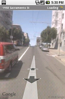
UPDATE: For those of you looking for Street View in Google Maps on Android, you'll find that we've integrated it more tightly with the rest of the app. Street View is no longer its own map mode. You can now check out Street View directly from any search result where imagery is available. You can also long-press any point on the map, in map view or satellite view, and you'll see a Street View thumbnail wherever imagery is available.
By Ole CaveLie and Chandan Pitta, Software Engineers
As mobile technology geeks, we're really excited to see a new smartphone launch from our friends at Palm. Palm Pre phone's webOS works great with Google Search, Google Maps, and YouTube, which are built into the device. You can also easily sync your Gmail, Google Calendar, and Google Contacts to Palm Pre.
We're big fans of Palm Pre phone's universal search feature. Just start typing a query from the home screen (no need to launch the browser). If your query doesn’t match any contact info or the name of an application on your phone, you’ll be prompted to search either the web with Google, local places on Google Maps, articles on Wikipedia, or Twitter.
What's neat about launching Google Maps in this way is that it will use your location to conduct a search for nearby businesses and points of interest (if you choose to allow Location Services, of course). Similar to some other mobile phones, Google Maps is built into Palm Pre phone's operating system -- you'll notice a Google Maps icon amongst the phone's built-in applications. However, the implementation of Google Maps on Palm Pre is actually very different from how we built Maps on platforms like Android or BlackBerry. Palm is calling its operating system webOS for good reason -- all applications running on webOS leverage a WebKit-based rendering engine for content, which made it easy to port Google Maps to the platform. You can use familiar Google Maps features such as My Location, local search, driving directions, and traffic.
Palm Pre also includes a YouTube application that Palm built using Palm’s Native application MoJo SDK, and much like a web app, it uses HTML, CSS, and JavaScript. YouTube on Palm Pre makes it easy to watch your favorite videos. When you play a video, it auto-rotates to landscape orientation to take full advantage of the phone's screen.
Palm Pre wouldn't be complete without productivity functions and we're happy to report that Gmail, Google Calendar and Google Contacts work well on the device. Simply enter your account name and password and Palm Pre will sync your email, calendar events, and contacts to the device. Palm Pre supports the IMAP IDLE protocol so you can enjoy push Gmail.
This is just the beginning for Google applications on Palm Pre. The good news is that since our applications are built using web standards along with Palm's MoJo SDK, we can iterate quickly and provide new functionality, often without requiring you to install anything new. We look forward to rolling out new features for our mobile applications at a rapid clip.
Update 6/8/09, 05:04pm - If you're interested in learning how to set up your Pre with your Gmail, Google Mail or Google Apps for Your Domain account, please visit our help center to learn more.
In January New York City Mayor Michael Bloomberg announced a partnership between Google and NYC & Company, NYC’s official marketing, tourism and partnership organization, to create a new website and high-tech information center. Using these new tools, you can now plan a trip to NYC from your home computer, transfer your itinerary to your cell phone, and then learn more at an information center.
A number of people have asked us about our role in the NYC partnership. We did not create nycgo.com and the Official NYC Information Center here at Google, as you'd probably expect. Rather, we provided NYC with our standard APIs and a bit of technical guidance, and NYC did the rest.
To help other cities and organizations gain a bit more insight into how NYC managed to create nycgo.com and the Official NYC Information Center, we put together this short video of interviews with principal members of the NYC project team.
Click here to learn more about the partnership between Google and NYC.
Just a week ago we announced Google Latitude, a new feature of Google Maps for mobile that lets you see your friends' locations. Today Dylan Casey, a former professional cyclist, announced another location-based service from Google. My Tracks is a new Android application that makes it easy to record your routes when cycling, running, hiking, or doing pretty much any outdoor activity.
Because the Android operating system supports background processes, you can run the My Tracks app while using other applications on your phone.
My Tracks also integrates with other Android applications to make it easy to share your routes. When you select "Share with friends," Android will allow you to share your track through other Android applications that can send messages. By default this is the Gmail application, but if you have installed other applications that can send messages, there will be more options. To demonstrate this we worked with the Twidroid team. It is now just as easy to tweet your tracks as it is to email them. Simply install the latest version of Twidroid available from Android market. Next time you share a track recorded with My Tracks, you can also tweet a link to your tracks!
To download My Tracks to your G1, go to Android Market and search for "My Tracks." And don't forget to check out the My Tracks website.
On September 23, T-Mobile announced the world's first Android-powered phone, the G1. The phone comes preloaded with Search, Maps, Gmail with Contacts, Calendar, Google Talk, and YouTube. The applications are easy to use, fully synchronized with the web, and work together in new and innovative ways, as explained in our first post in the blog series: 'Google on Android'. Over the next couple of weeks, we will put the spotlight on each one of the Google applications for Android. Today: Maps. -- Marc Vanlerberghe, Product Marketing Director.
When we designed Google Maps for the T-Mobile G1, we set out to create a great mapping application that took full advantage of the G1's hardware, like the touch screen, accelerometer, and GPS, as well as the deep system integration made possible by the Android platform.
One of my favorite things to do with Google Maps on Android is to explore new and favorite places. You can pan around and zoom in and out easily using just your thumb on the touchscreen -- a big plus for all those times when that other hand is unavailable. And if I want to see a restaurant or building up close, I can switch to Street View and view a panorama from street level. I can even turn on Compass mode to let me look around the panorama by moving my phone up, down, and to the side. It's like popping up a virtual periscope anywhere you want to check out what's there with your own eyes. Check out the video below for a quick demo. Note that Street View on Android is only available in the US at this time.
When I'm in a new city or just a new part of town, I like to turn on My Location. It can use GPS or just the nearest cell tower to tell me where I am and re-center my position in the middle of my screen when I approach the edge. When I'm walking or in a taxi in a dense city, like New York, I zoom in to street level and turn on GPS for the highest accuracy.
And as I wander the city, I can search for nearby businesses (like restaurants), and use Android's integrated Map features to save search results to my contacts. For instance, if I find a restaurant that I like, I can save it to my contacts and then later on call it or Map it with one touch. In the future, when I do another search with Maps, I might even see this contact again as a suggested search result along side past queries.
Maps is also integrated with email, IM, and the web on Android. For instance, street addresses that appear as plain text in these apps become touchable zones that you can click on to take you straight to Maps. Something similar happens when a Google Maps link is pasted into an email, IM or placed on a web page. When I touch it, I can choose whether to view the map in the browser, in Google Maps, or in any other application that's built to handle what's known to Android developers as an "intent." Or, I can make the choice once and save it as my default map-viewing application (Google Maps, in my case).
Perhaps best of all is that most of the resources, flexibility, and functionality in Google Maps are available to any application written for Android. Cab4me and Locale are both Android Developer Challenge winners that used the Android platform to build compelling applications with maps and location at their core. Any developer can use Android's MapView and location APIs to build location-aware mobile applications like these. While the team is proud of Google Maps on Android and other cool applications we've seen to date, we're equally excited to see what new kinds of maps and location-enabled applications developers create in the coming months.
Posted by David Conway, Product Manager, Android Team


 see a restaurant or building up close, I can switch to Street View and view a panorama from street level. I can even turn on Compass mode to let me look around the panorama by moving my phone up, down, and to the side. It's like popping up a virtual periscope anywhere you want to check out what's there with your own eyes. Check out the video below for a quick demo. Note that Street View on Android is only available in the US at this time.