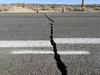
GEOLOGICAL FAULTS

Cave of Death in Costa Rica! No one returns alive. Here are all details
This cave in Costa Rica isn’t safe to enter. The presence of extreme levels of Carbon dioxide results in asphyxiation of any living being that enters the cave, resulting in instant death.

Why is Taiwan so exposed to earthquakes and so well prepared to withstand them?
Taiwan experienced its most potent earthquake in 25 years, resulting in at least nine fatalities, numerous injuries, and significant infrastructure damage. The island, situated along the Pacific "Ring of Fire," faces frequent seismic activity due to the interaction of tectonic plates. Despite this, Taiwan's preparedness for earthquakes is considered advanced, featuring strict building codes, a robust seismological network, and comprehensive public education initiatives.
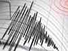
Earthquake could damage major areas of US, claims report
Around 75 per cent of the US may witness strong earthquake, as per a study by US Geological Survey (USGS).

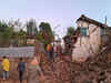
Final bodies found after China's most serious earthquake in a decade
The earthquake, whose epicentre straddled Qinghai and Gansu, was the most serious in China since a magnitude 6.5 temblor struck the southwestern province of Yunnan in 2014 and killed 617 people.

5.9 magnitude earthquake shakes Indonesia's Aceh province
Indonesia's Meteorology, Climatology and Geophysical Agency said there was no danger of a tsunami but warned of possible aftershocks. The agency put a preliminary magnitude at 6.3. Variations in early measurements of quakes are common.
Strong earthquake that sparked a tsunami warning leaves 1 dead amid widespread panic in Philippines
The U.S. Geological Survey reported that the quake Saturday night had a magnitude of 7.6 and struck at a depth of 32 kilometers (20 miles). The Pacific Tsunami Warning Center said it expected tsunami waves to hit the southern Philippines and parts of Indonesia, Palau and Malaysia, but later dropped its tsunami warning.
- Go To Page 1

Char Dham project: Detailed geological study is needed before infra activity in Himalayas, says environmentalist Ravi Chopra
The Silkyara tunnel is part of the Union government’s ambitious Char Dham Mahamarg Pariyojana. It is a highway widening project for almost 900 km in Uttarakhand to provide all-weather connectivity to the Hindu pilgrimage sites of Gangotri, Yamunotri, Badrinath and Kedarnath. In August 2019, the Supreme Court set up a high-powered committee to examine the “cumulative and independent” impact of the project “on the entire Himalayan valleys”.

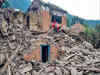
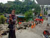
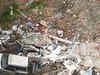
Uttarakashi tunnel: What happens after trapped workers are rescued?
An under-construction tunnel in Uttarakhand collapsed, trapping 41 workers inside. Despite challenges faced during the rescue operation, rescue teams are making relentless efforts to save the workers. The collapse may have been caused by a geological fault, and the absence of an escape passage in the tunnel is a shocking revelation.
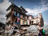
Why does western Nepal face threat of a bigger earthquake?
“There has been a collision between Indian and Eurasian plates going on underground for a long time which has accumulated tremendous energy,” Bharat Koirala, senior seismologist at the National Earthquake Monitoring and Research Centre, Nepal, told PTI.

Scientists uncover Zealandia: The lost continent beneath the waves
Scientists have recently unveiled Zealandia, a long-lost continent submerged beneath the ocean's surface for 375 years. Zealandia was originally part of the ancient supercontinent Gondwana and its discovery sheds light on Earth's ancient past and geological evolution. Zealandia is the eighth continent discovered and its existence provides scientists with insights into Earth's geological evolution and the formation of supercontinents.

What caused Morocco's earthquake? A geologist studying the Atlas mountains explains
The recent earthquake, which was caused by a geological phenomenon known as a "reverse fault," suggests that stress from the plates pushing together had been building up underground for a long time. Authorities can mitigate the impact of earthquakes by identifying active fault lines and improving seismic building design codes.
Mild earthquake hits UK with epicenter at Tean, no casualty
Confirming the earthquake, the British Geological Survey said that tremors with a magnitude of 3.3 on the Richter’s scale were recorded. The epicenter was 7.3 kilometers or 4.5 miles below Tean.
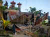
Earthquake hits Indonesia, killing four as restaurant collapses
The US Geological Survey said the magnitude 5.1 earthquake hit residential areas in Jayapura, near Papua's northern coast and was centred at a depth of 22 kilometres (13 miles). Shallow quakes often cause more damage on the Earth's surface.

Central Turkey hit with another 5.5 magnitude earthquake
As the time from the original earthquake extends, the frequency and magnitude of the aftershocks tend to decrease. However, 5.0 to 6.0-plus aftershocks are still likely to occur and bring a risk of additional damage to structures that are compromised from the original earthquake. This brings a continued threat to rescue teams and survivors, reported CNN.
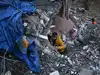
Why was the Turkey-Syria earthquake so bad?
The epicentre was about 26 km east of the Turkish city of Nurdagi at a depth of about 18 km on the East Anatolian Fault. The quake radiated towards the northeast, bringing devastation to central Turkey and Syria.

Over 2,600 dead in Turkey-Syria earthquake; WHO warns toll could rise further
The quake, felt as far away as Cairo, was centered about 90 kilometers (60 miles) from the Syrian border, just north of the city of Gaziantep, a major Turkish provincial capital of more than 2 million people. At least 20 aftershocks followed, some hours later during daylight, the strongest measuring 6.6, Turkish authorities said.

Powerful earthquake shakes Indonesia's Sumatra, kills 1
A 62-year-old man died of a heart attack while fleeing to safety in Tarutung village, which is closest to the epicentre, said local police chief Johanson Sianturi. Eleven people have been injured and at least 15 houses and buildings damaged in the village, he said.

Earthquakes shake Indonesia, Philippines; no tsunami threat
The Indonesian Meteorology and Geophysics Agency said the quake was felt in many parts of the province but there was no danger of a tsunami. It was occurred just before dawn and was centred about 161 kilometres southeast of South Nias, a district in North Sumatra province.

Strong quake shakes Indonesia's capital; no tsunami alert
The U.S. Geological Survey said the magnitude 6.6 quake was located in the Indian Ocean about 88 kilometers (54 miles) southwest of Labuan, a coastal town in Banten province. It was centered at a depth of 37 kilometers (23 miles), it said.
Moderate earthquake rocks Indonesia's Bali, killing at least 3
Indonesia, a vast archipelago of 270 million people, is frequently struck by earthquakes, volcanic eruptions and tsunamis because of its location on the "Ring of Fire," an arc of volcanoes and fault lines that arcs the Pacific.

Magnitude 5.9 earthquake strikes southwestern Iran
The US Geological Survey called it a 5.8 magnitude earthquake, located at the port city of Bandar Genaveh. It described its depth at 10 kilometers (6.2 miles).
NCS conducting geophysical and geological surveys to study earthquakes in Delhi-NCR: MoES
Delhi experienced four small earthquakes during April - August 2020, with the first event of magnitude 3.5 on April 12 in the northeastern boundary of Delhi.
Foreshocks, swarms caused recent earthquakes in India, says Geological Survey of India official
Dr Sandip Som, the deputy director general of GSI, also said that foreshocks -- mild tremor preceding earthquakes -- or swarm activities -- series of earthquakes -- indicate release of tectonic stress and strain during the continuous deformation process, and a detailed study of these jolts could help predict if a significant seismic event is in store.

China looks at an Indian to save itself from natural disasters
Geophysicist Paramesh Banerjee will be the first Indian to head a Chinese scientific institution though many Indians scientists already work at Chinese institutions.
Major earthquake may shake Jammu & Kashmir, millions life endangered: Study
Though the Riasi fault is not very prominent on maps, they are based on the history of seismic activity rather than the potential for future events.
Predicting earthquakes is very much a work in progress
After the dust settles on the tragedy, the current Nepal earthquake will provide an opportunity to advance our understanding of earthquake science a wee bit.

50 districts in Uttar Pradesh quake-prone
The NIDM has divided the state into three zones, with areas bordering Nepal and Uttarkashi in Uttarakhand figuring in Zone-IV.

Smartphones could help detect earthquakes early
Sensors in smartphones and other similar devices could be used to detect early ground movement to warn people about a potential earthquake.
Tibetan plateau basin lost significant height: Study
The Tibetan Plateau in south-central Asia, because of its size, elevation and impact on climate, is one of the world's greatest geological oddities.
Load More